Tuesday, February 23, 2016

Winding down??

With the passage of this storm, and the next few also looking to our west, and with temps forecast on tv into the 50's again, its time to start wondering if the groundhog was right. 

Snow map for GFS through 3/10
CMC through 3/4


Or go with the Euro control out to 3/9
We just can't lock in the cold this year, and when it comes, a day later it rains.

Wednesday, February 17, 2016

Feb 24-26

2-23

Ukie wins  - some front end snow today, .6" with 2:1 snow ratios - ie really wet.  Enough to cover the ground.  Rest of storm to pass well to our west.

2-19   Model mayhem continues....
Afternoon - two storm solution evolves, front snow?, second mix?

Ukie - way west
Euro with 2 storm solution that CMC had at 0z.  Bernie mentions he favors this and second one is bigger.


JMA also now has two storm solution


Morning
0z euro back west, right over us.  EPS really far west.  Some snow tonite, sunday night, tuesday then rain, perhaps ending as snow.

EPS

 GFS is ALL over the place - 0z run to our east, but rain. 6z over Cleveland, 12z two storms, one hits us, the other ots.
0z run gfs

6z gfs run

12z gfs first storm

12z gfs second storm
0z cmc is a two storm solution, both rain


]]]]]]]]]]]]]]]]]]]]]]]]]]]]]]]]]]]]]]]]]][[[[[[[[[[[[[[[[[[[[[[[[[[[[[[[[[[[[[[[[[[[]]]]]]]]]]]]]]]]]]]]]]]]
2-18   Afternoon - Euro shifts way east, still has 2-3 for this storm, brings .55qpf for monday morning mayehm

Euro 12z run

Euro 0z run
GFS moved from over us to offshore as well.
gfs 12z


gfs 0z
JMA went a little south
CMC caught up with the 0z runs
CMC
NAVGEM way out to sea.

UKIE is cut off over AL


Ensembles look good - close enough to warrant watching.  GFS ens has 2m temps near 0


GFS Ens

Euro ens


 Morning.  0z GFS and 6z GFS for comparison below.  0z Euro similar to 0z GFS.  I'll throw in CMC and NAVGEM too, just to demonstrate the only model runs that were remotely close were the 0z GFS and 0z Euro.  Looks like same situation as the past storm from their operationals.  The EPS and GEFS ensembles are more reasonable and up the coast. But rain/snow line is close.   Note clipper on Monday morning may bring a few inches per Euro, misses south on both GFS runs.

CMC
 
NAvgem

0z GFS

6z GFS


2-17   Afternoon

GFS remains wet and wild, really slowed down and has 850 temps to 10c.
Euro on the other hand went full blown bomb coastal, faster than before, but colder and all snow for DXR.  Has over a foot for our area, and that may be underdone

ECMWF Deterministic FORECAST FOR:  LAT =  41.38  LON =  -73.46

                                            12Z FEB17
                 2 M     850     SFC     SFC     700    TOTAL    500    1000
                 TMP     TMP     PRS     RHU     RHU     QPF     HGT     500
                 (C)     (C)    (MB)    (PCT)   (PCT)   (IN)    (DM)     THK
MON 12Z 22-FEB  -0.5    -1.2    1012      95      55    0.09     547     538   
MON 18Z 22-FEB   6.1    -2.2    1012      63      40    0.09     549     539   
TUE 00Z 23-FEB   2.9    -4.8    1016      71      15    0.09     551     538   
TUE 06Z 23-FEB   0.1    -5.0    1019      76      14    0.09     552     537   
TUE 12Z 23-FEB  -1.1    -4.1    1022      73      14    0.09     554     536   
TUE 18Z 23-FEB   4.3    -3.7    1021      47      20    0.09     555     538   
WED 00Z 24-FEB   1.6    -3.2    1019      62      97    0.09     555     540   
WED 06Z 24-FEB   0.5    -2.9    1015      89      98    0.15     554     542   
WED 12Z 24-FEB   0.1    -1.3    1010      86     100    0.31     551     543   
WED 18Z 24-FEB   0.7    -1.1    1005      84      85    0.52     548     544   
THU 00Z 25-FEB  -0.6    -0.8     997      87     100    0.70     542     545   
THU 06Z 25-FEB  -3.1    -4.5     992      85      99    1.33     530     537   
THU 12Z 25-FEB  -4.3    -9.6     994      73      93    1.50     525     530   
THU 18Z 25-FEB  -1.7   -11.3     997      49      31    1.50     522     524   


JMA also showing coastal


Morning  Euro and GFS are toying with a major storm in this time frame.  It has been on multiple runs now.  Differences are that Euro captures the LP right over us, and spins it out, snow to zr.   GFS keeps it moving and is warmer -rain to snow.   Here is the text - its nasty. Note on Thursday the 850 temp is at .1 up from -1.2 and .58 has fallen.  Its likely that 8" could come before it changes to ice. 

ECMWF
                2 M     850     SFC     SFC     700    6 HR     500    1000
                   TMP     TMP     PRS     RHU     RHU     QPF     HGT     500
                   (C)     (C)    (MB)    (PCT)   (PCT)   (IN)    (DM)     THK

WED 06Z 24-FEB   0.2    -3.0    1022      75      90    0.08     557     539   
WED 12Z 24-FEB  -0.1    -2.2    1021      83      98    0.12     559     542   
WED 18Z 24-FEB  -0.3    -1.2    1018      84      99    0.31     559     545   
THU 00Z 25-FEB  -1.1     0.1    1012      86     100    0.58     559     549   
THU 06Z 25-FEB  -1.6     4.2    1008      85      81    0.28     557     551   
THU 12Z 25-FEB  -0.6     2.2    1006      86      20    0.06     552     547   
THU 18Z 25-FEB   1.5     0.1    1005      88       9    0.03     548     544 
GFS 6z
GFS 0.5 Degree FORECAST FOR:  LAT =  41.38  LON =  -73.46

                                            06Z FEB17   * - APPROXIMATED
                             2 M     850     SFC     SFC     700    6 HR     500    1000
                             TMP     TMP     PRS     RHU     RHU     QPF     HGT     500
                              (C)     (C)    (MB)    (PCT)   (PCT)   (IN)    (DM)     THK
WED 06Z 24-FEB   4.6     6.0    1006     100      98    0.24     558     553   
WED 12Z 24-FEB   3.3     5.4    1007      96      98    0.04     557     551   
WED 18Z 24-FEB   3.6     4.5    1006      94      98    0.11     556     551   
THU 00Z 25-FEB   3.2     5.2    1000      94      99    0.06     553     553   
THU 06Z 25-FEB   2.4     2.3     989      95      96    1.08     544     553   
THU 12Z 25-FEB   0.2     0.0     985      93      98    0.28     531     544   
THU 18Z 25-FEB  -1.1   -10.6     992      86      70    0.18     526     533  
CMC has a different look - it never develops a coastal, instead brings a northern stream system across on the 26th with all snow, but lighter amts.
JMA has two systems - coastal then the one the CMC has.  Its warmer with the High a little too far east and south for the cold air to stay, but still should be some front end snow.
So all long range models are on board with something-  just need to work out whether its inland, coastal or out to sea.  Don't think its a Great Lakes cutter but can't rule it out yet.

Thursday, February 11, 2016

2-15 to 2-19

2-15  Morning low of -6.3 at 7am.  Was 6+ at 9 and 10 at 10.  Light snow/flurries.  Watching to see if this overproduces. Weak LP off VA and HP just NE of CC is keeping strong southerlies away for now. If these strenghten, watch out for ice.  Current HRRR has .25" of ice forecast.

2-14  morning low of -10.  At 11am its 2.

No real changes except the follow clipper is drying out.  The 0z Euro came east over NYC, and it seemed like there was some consensus, then 12z GFS went back to Pitt/Buf.  The run to run consistency just isn't there and its 2 days away. 0z Euro even toyed with the idea of spawning a coastal low.

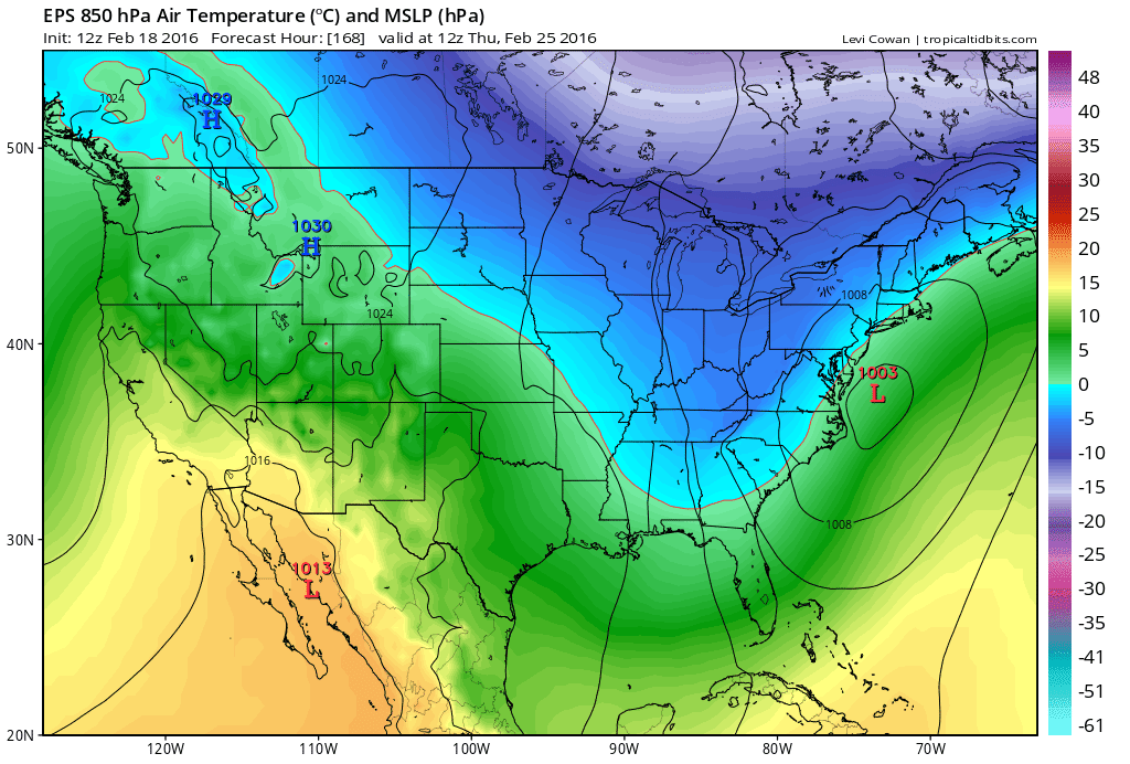
No matter what fluctuations, a high pressure to our east brings southerlies which would scour the cold air.  What we need is a low to from offshore to keep the cold air entrenched, but also would allow for ice.  Though there is toying with that idea, its not seriously being considered.   Snowfall from the front end should be 1-3 with 1-1.5 inches of rain.  Warm front should have snow, once passed drizzle, perhaps brightening of skies, then really heavy rain with a cold front.


Not having much skin in this one, its been remarkable to watch.
 +++++++++++++++++++++++++++++++++++++++++++++++++++++++++++
2-13  morning low of 13 up to 21 by 10am despite arctic front passing, snow showers

The models are really messing around.  The GFS is weakening the low so much that it goes over us or just to our east, but still brings snow to rain.  NAM is over us.  Euro still to the west as it takes the trough negative earlier and winds up the storm earlier. CMC is similar to GFS. UKMET winds it up like the Euro and takes it to the west.

After that there is a weak clipper that is right behind it, which varies from a snow even to a non event.  Potential is there for a 1-3 inch event, which would cap off a crazy 72-96 hrs of weather where the potential low is -10 on Sunday, to a high of 50 on Tuesday and snow on Wed.

Right now I like the track of taking it up the coastal plain, rather than the spine of the Apps.  I still think its difficult to go from a -10 temp to a 50 temp without a major storm, though a 1040 high located to our ENE helps with that. Though I still could see this storm winding up earlier than even the Euro and going more over Pitt/Buf, but time is running out to see that drastic change on the models.

More on this later if it shifts more to snow, or shows over 2" on the front end, which its not now, but should be doing. Then again, we should have had more snow with the arctic front last night.  Perhaps due to it being at night, more stability in front of it even though there was a SW wind.

2-12  0.3 degrees this morning at 7:20

GFS bullseyes us with the low pressure on Tuesday evening. Warm air well in front is suspicious. 

 Euro shifted east, but is still west of the GFS, with the LP running PHL to ALB
Both have temps in the 50's during this event, which would be nice, but I think a little high
CMC runs it right over us.  JMA from 12z 2-11 runs it east of us but is also warm. NAVGEM just to our west, similar to GFS.  UKMET goes GA to ALB.  
Will continue to monitor, in case it shifts east or shows more of a front end snow.


2-11 As we start submitting to old man winter, polar front should bring some squalls for a dusting on the 12th/13th.  Then below 0 weather with highs in single digits should be in play Sat/Sun.  Then a storm forms in LA, swings through AL on Monday with warm air surging ahead.   Monday night should have snow, but all indications are an inland track of the storm.  This means a snow to rain event.  It is shocking to see how fast the cold leaves the area on Monday, almost unbelievable, to near 50 on Tuesday.  We would have to see some front end snow, but the high slides offshore bringing in SE winds, so at this point, its more of a 1-3 or 2-4 quick hit then a lull as it warms and rain.

At this point 12z GFS is east of 12z Euro, which is not unusual.  The jump west on the Euro from 0z (over us) to 12z (over State College to Buffalo) is a little dramatic, but I'm not going to be surprised if this moves further west on the GFS. GFS is jucier with the warm front, Euro pretty dry.  I believe the GFS on that.   NAVGEM rule in effect - it has the storm Harrisburg to Albany.  Watch for GFS to shift west.

Previous runs had a system trailing the one on the 15th/16th , which has disappeared from 12z runs.

Warms afterwards.

Storm 3 - could be the one! (spoiler, it was)

 2/9  Set up is an upper low over TX that heads northeast into TN valley and then transfers off the coast. At the upper levels, there's ...