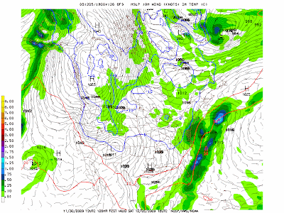
So the 12/2 storm scoots to the west of the mountains, and the cold front comes through, but the upper low is still left behind, spawning a potential light event, albeit the first one, on Saturday 12/5. The image above has the freezing line at the surface, so you can tell that its all snow and sticking.
12/2 evening update - NAM 18z has a bunch of snow, but 0z backs off to a 2-4inch amount. Euro brushes us, Can out to sea. GFS brushes us. More at the coast, still, for now.
12/2 evening update - NAM 18z has a bunch of snow, but 0z backs off to a 2-4inch amount. Euro brushes us, Can out to sea. GFS brushes us. More at the coast, still, for now.


.gif)
2 comments:
Most models have this going out to sea now. Gfs is furthest west with some light snow. More concerning is that while the AO ensembles are clearly way, way negative going forward, the gfs runs still have storms cutting to lakes bringing warm air in for every storm. Or, if a clipper, it goes too far south out to sea.
CAN still out to sea completely. Euro has us in the moisture column for some snow, but a brushby. GFS and DGEX still passing just too much to the east to have anything but a dusting.
Post a Comment