AFternoon runs - OUT TO SEA!!! No more posts unless this changes.
--------------------------------------------

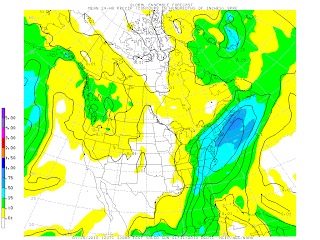
above: gfs ensemble 24 hr precip for ending Sat nite 1/30
1-25
0z GFS - no formed storm on Saturday - week stretched out lows on Friday south of OBX
6z 996 low heads just south of benchmark on Sat nite - good snow
12z further out than 6z, but still heads north southeast of benchmark. no snow
Candian - 0 and 12z runs have snow, but southeast of benchmark sat morn. weaker at 1004
Euro - 0z brushes CT going from OBX to Nova Scotia Sat to Sun. Only at 1006 as it goes by deepenint to 996 sun nite as it hits Canada. 12 z looks a little closer, but still only brushing us. A bit stronger with a 992 off Cape Cod (150 miles or so though)
UKMET 0z and 12z similar paths near benchmark, with the 12z run having a 980 low.
DGEX - 6z has no real formed low, except down at Myrtle beach heading due east. 18z has it coming further north of OBX, but then turning south. only at 1006
GFS Ensembles have it coming just southeast of BM. But spreads the precip wider than on the GFS operational, so that we get at least 6+ see picture above

1-24 Above is the 0zEuro for 1-30 with the storm right off cape cod. Canadian was same. The 12z runs also had similar look with storm just a tad further east.
0z gfs has no storms at all
6z gfs goes off the delmarva - bringing snow
12z gfs is south of hatteras
ukmet looks south, but hard to tell this far out
6z dgex is off hatteras


.gif)

No comments:
Post a Comment