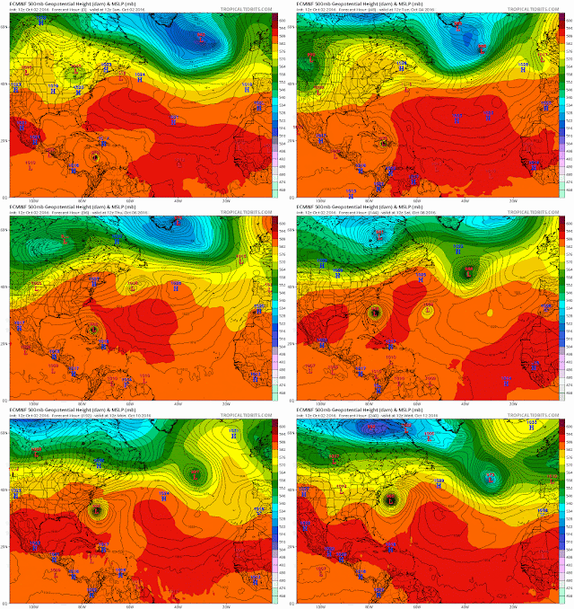
This loop was in my dump page and used on Accuweather forums to describe how Matthew would lose its energy into the trough, and maybe even down to 700mb no longer exist as those layers merged with the trough. Also used the 850mb to show escape of energy, though the steering currents at 850 were favorable for that layer to continue southward. Essentially, 500mb layer and up goes NE, not sure about 700mb layer and 850 to surface heads southeast in response to the HP and 850 ridge building from the north.
You can see the energy stream out of the 850 layer but it retains enough to continue south.
Here is the new gfs now agreeing - granted its one run, but the UKMET is also agreeing as is the NHC now. The surface map shows the convection shearing north into the trough. This is happening now.
And from todays 11am NHC disco
Most of the global models, primarily the GFS and the UKMET, forecast
that Matthew will become entangled with a cold front, and the new
NHC forecast calls for Matthew to become absorbed within this
frontal system within the next couple of days.  During the next 12
to 24 hours, while the Matthew is hugging the US coast and taking on
a more extratropical structure, the tropical-storm-force winds are
expected to expand and strengthen in the western semicircle and
continue to affect portions of the coast within the warning area.

Matthew is already embedded in the mid-latitude westerly flow and is
moving toward the northeast or 050 degrees at 10 kt. The steering
pattern is forecast to persist for the next day or two, and on this
basis the NHC forecast moves the cyclone eastward until it becomes
absorbed.  Previous NHC official forecasts followed the EMCWF in
keeping the cyclone a distinct entity longer and looping it
southward, but even if this the case the system will likely be only
a broad area of low pressure.
But they still need to watch this doesn't come back to Canada (or even Maine).
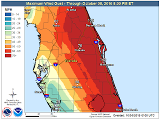
10-5 Yesterday, the euro went down for an hour and was delayed. Once it ran the 12z run, all things changed. Storm would run up FL, GA, SC, NC out east, south, west and hit FL again. GFS followed, UKMET followed, NAVGEM not quite as dramatic and lastly the CMC. HWRF and GFDL also have FL hits or grazes. So with all models on board, the storm will blow through bahamas now, not stall, and will impact FL. Here is what the Melbourne NWS predicts for peak wind gusts.
I'm still not convinced of a broad loop. There is a gap between the highs to the north, but once Matt turns east, he loses the tops of the storm and the convection is blown into the trough. The surface to 700mb layer remains. It may stall off FL then head NE, or just head E or NE. But with the Atl ridge heading east, and a ridge building in from the SW, I don't see how it crosses FL into the gulf. It would need to go all the way around the keys.
  |
| Euro 66 |
 |
| Euro hr 78 |
 |
| GFS hr 66 |
 |
| GFS hr 78 |
10/2 Some runs from today. Models agree up to what happens past the Bahamas. One camp misses the first trough and stalls, and is captured later. This results in the storm still being well offshore at 240, but looking like its headed towards Canadian Maritimes. The other models show a little more influence from the atlantic ridge and approaching trough, keep the speed up, and in various scenarios, scrape the coast. These runs had landfalls in NC, CT/MA, ME or Canada. The energy with this trough should be sampled on Monday.
UKMET is on its own hitting Florida.
GFS 12z
Euro 12z
JMA 12z run
NAVGEM 12z
GFDL 12z
HWRF 12z
GEFS trend since 10/1/0z
9/30
Jamaica, Haiti and Cuba still in the cross hairs. Matthew blew up today to a 120mph storm. Latest recon has 958mb. Models in good agreement now until it emerges from Cuba. 12z Euro run is really bad for the Bahamas. These are 850 winds, not surface. 12z GFS hits Maine/Nova Scotia.
 |
| 12z Euro |
 |
| 12z GFS |
9/27
GFS 18z run is NOT GOOD for the tristate.
6z also had it near LI
0z by the islands
 |
| 6z gfs 9-27 |
 |
| 0z gfs 9-27 |
9/26
Geez - GFS all over the place
GEFS now shows a stall - not good
GFS - 0z . Haiti on the 3rd, Bahamas on the 4th, BM on the 6th at 961mb and 12hrs later landfall Nova Scotia at 960mb.
6z Grenada/St Vincent on the 29th then develops to hurricane on the 30th N of Aruba, Bonaire etc., 100kt winds on the 3rd at DR, TS force in Bahamas on the 4th, back to hurricane hitting Bermuda on the 6th.
Euro - 29th Grenada, 1st Aruba, 5th Haiti
CMC - 29th Grenada, 30th Aruba, 3rd E. Jamaica, 4th Bahamas, 6th well offshore obx.
EPS - 0z today. Wave organizes past Barbados, skirts S. Amer. Develops stronger just to the west of Jamaica. Hits Cancun, then goes in south of Brownsville.
9/25
Still at the end of their runs, but the EPS and GFS are showing a hurricane in the Carribean/Gulf during the 1st week of October. Last four runs of GFS all put Jamaica in play.
12z yesterday - brushes S coast of Jamaica the 4th, hits Yucatan on the 6th then goes south of TX
18z yesterday - hits W Jamaica on the 2nd, W Cuba on the 4th, Fl Panhandle on the 7th
0z today - brushes SW Jamaica on the 3rd W tip of Cuba the 5th, FL Panhandle the 8th
6z today hits W Jamaica on the 2nd, central Cuba the 4th, Keys on the 5th, rides up the W coast of FL the 5th to 7th.
12z today - hits E Jamaica on the 3rd, E Cuba the 4th, Bahamas the 5th, passes outside the BM at 953mb on the 7th.
18z - hits Haiti on the 3rd, Bahamas on the 4th, stays off east coast
| 12z GFS |
EPS Control
12z yesterday - skirts northern S AMerica, rides up Central america coast, hits Yucatan and Mexico
0z today hits E Jamaica the 5th, E Cuba 6th, Bahamas 7th and rides up E Coast brushing OBX the 8th and ACK the 9th.
12z today - storm kinda forms and runs along/into S. Amer. It doesn't really recover and the wave goes past Jamaica, Yucatan into Mexico.


No comments:
Post a Comment