Friday, February 19, 2010

It goes beyond the 23rd...

2/22 - ok its 10pm and snowing at 34 degrees and 87rh. Not much more room for cooling although obs in Trenton are below freezing. I'm still doubtful it gets cold enough or snows hard enough to stick to the streets.

12z Looks like NAm is too late (no precip til 7am), UKMET gets it right, cmc too slow, gfs right. euro doesnt have the resolution to tell

So it looks like wet snow, light amounts overnight. UK met keeps it cold, nam warms it. CMC keeps us on the line through 72 hrs. Euro has right thicknesses (under 540) and keeps us under freezing, but barely, for the next week. GFS has right thicknesses, but goes to .8 at 850 for 6hrs on Wed. Its amazing the different timing, strengths and tracks being taken.

Beyond Wed is going into another thread.


2-21


12z
Euro - still keeps it cold enough at 850 to be all snow, so long as boundary layer is under 35.
UKMET - up to 72 hrs, looks like snow starts 6-12z tuesday and comes down hard later that day. Again, 850 line south of LI, so only real warm boundary layer should be causing rain
CMC - keeps 850 line on CT coast until 12z wed when its 992 low tracks up to nyc. from there it heads to buffalo, keeping us warm. But then the third low comes up and tracks around montauk, to Springfield, to Albany to Scranton to N NJ. Thickness lines after wed are clearly snow, but BL temps are in the 30's
WRF - secondary goes se, minor snow, then another forms and pushes 850 line and thickness line just on the coast. Keeps dxr mostly around .5 - (1.5) so its right on the r/s line. Wednesday is the real start and the phasing with the third system not until later thurs. If that happens, should be snow as the 540 thickness line runs from obx to ack. The 12z was much warmer in the beginning though.
GFS -18z - this just doesnt happen. The secondary stays south enough that the 850 line mostly stays south of us, except at 6z wed. Thickness stays south of us. It precips for a long time. The third storm phases well out to sea, then loops around into boston and sits there for friday and saturday, at 976! Snow reaching all the way to DXR from this! nuts.
12z - similar to 18z, but does not stick in bos as long. Both runs have dxr very close to r/s line and it depends on BL temps.
GFS ENS - using dominant precip type, only rain for them is at 18z on wed. rest is snow on 18z run. SREF is mostly rain though.


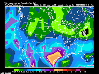
Precip amounts. Wrf has over 2 inches and thats just tues and weds. Gfs looks similar. The max it can do is 60 hours and this event will be much longer. The accuweather gfs has most of CT getting at least 2.5 inches of precip this week, with eastern parts closer to 3 and parts of Mass at 4. snowfall map has parts of vt, ma and ny with over 24 inches while ct has some... see above.


2-21 0z/6z


UKMET - holds off snow until tuesday night as first one goes to lakes and peters out. Second comes up coast for Tues nite and sits over us wed-fri

Euro - Moisture comes in mon nite as snow. 1000 low reforms off delmarva on tues nite, with dxr staying under freezing at 850. Low moves due north over BDL on Wed nite, then due East on Thurs nite when the third impulse catches up with it and it bombs out to 988 around the BM. Then it retros back into Mass on Fri nite. to Alb Sat nite. Model output for 850 temps all under 850 for dxr and RH from tues nite onward is in the upper 80's to 90's.

CMC - snow moves in Tues morn as secondary forms, secondary goes right up over NYC and hudson on Wed, putting us in the warmer sector. then it cuts off, and cold air pours in, putting us in the cold sector by wed nite. Then it just spins around NY/W New england for a few days with impulses coming in and going out, all under 0 at 850.

wrf - 6z - now has first storm dying with second forming to our south and heading ne, missing us for tuesday, but retrograding on wednesday, with us in the under 0 at 850 sector.
0z was similar non event as it did not retrograde

gfs -6zz holds off snow until tues afternoon, runs secondary out around li into RI. keeps weak until third system catches it over Bm, then pivots into CCOD area on Friday at 988. we are below 0 at 850 through the week, but surface temps are around 30-35.
0z run brings snow in tues morn, with secondary running to BDL, wed morn at 992, spinning and petering out, with third system coming in, but further east over BM and east of CCod and doing a loop over Ccod. see precip output for 6z above


2-20 - models still a mess, with some putting nothing down for the first, but loading the second, some snow, some rain. the 0z run 2-21 has a huge amount of precip 3 inches in CT. see above. Its not all snow, maybe even very little. The dgex 18z also had a lot of snow on the ground in the hills NW CT. like over 24 inches. Problem remains too much warm air to start and low is too close (actually on top of us)

2-19 The afternoons runs for today show that the 23rd storm is trouble to forecast. This will be difficult to describe in words but I'll try
Euro - takes low in IL (1002), splits it primary into the lakes and secondary over NC/VA on Tues. Secondary takes over somewhere off NJ, but weak (1006) on Weds. Sits around the BM on Thurs and moves NW from RI to Ontario (996) on Fri. It keeps us right on the cold side of the 850 line and 540 line, but barely and I can see how it sleets or rains instead.

UKMET goes from MO on Monday, north into lakes Tuesday, but reforms off NC/SC. Goes north to Delmarva on Wednesday and to LI/CT on Thursday(992). Would guess this is snow to rain, but can't tell how much and when the change occurs.

GFS - 18z run is facinating. Over KY,IN and IL on Monday morn. Up to the lakes as a 1000mb with snow moving in Monday night here. Secondary forms Tuesday morn off OBX with steady snow continuing. Lakes low dissapates and secondary moves just southeast of BM, with still snow on Wed morn, but lightening up, at 998. Thursday it moves NW and dissapates while another storm is forming off NC. The old storm pushes the 850 line west with it, while the new one comes up the coast and centers (992) over C May Thurs morn. Thurs afternoon it goes to Scranton (988) and sits until Saturday as it moves over New England. The deepening on Thurs afternoon brings more cold air into it, pushing the 850 line east, with precip finally ending on Saturday. So it goes from snow, to rain, to snow. However, surface temps over most of S NY, CT, MA, NJ are all above 32 for most of the time.

DGEX - keeps with the primary to lakes, secondary off coast, keeps it all snow for us on Tuesday. Breaks the weather Wed Afternoon until Thurs afternoon when another low forms over SC, never makes it to the water?? and goes to philly pushing the 540 line all the way west to PIT.

CMC - Low monday over S. IL. Primary goes to N IN on Tues, with secondary forming over delmarva as snow begins tues morn over us. Wed - Old low weakens, secondary sits off NJ by NYC and spins for a day as old low kicks it out. After moving past BM, new low and old low (still over NYC) move almost due west back to Ontario and CCOD. just as weird as GFS, but results in all snow.

GFS ENs - 18z run has low over IN on mon. fades to the lakes and secondaries on tuesday over obx. Moves over BM on Wed 1000. East of CCod, barely on thurs. Weaker low develops thurs and moves east of here friday to about portsmouth. Only has rain for 6 hrs on wednesday.

whew
So the american models see the system coming up from the south, the CMC, UKMET and Euro don't. fun!

Tuesday, February 16, 2010

Possible 2-23

2-18
12zs
gfs - low from WV to OBX with secondary over SC, consolidates East of Cape May, passes se of bm and hangs around CCod . Some snow, not alot. 18z is really bizarre as it goes well SE of BM but still brings in lots of snow, then it turns around and heads NW over CCOD. As it heads over CCOd another low forms off NC and follows NE to E of BM where it turns NW and heads right over CCOD on Friday. Gotta throw both of these out!
Euro - From Cape May to CCod, then NW into ME/NH border. Could have rain from it, especially near the coast. Most normal scenario
CMC - brings low to IN hen secondaries over VA and it sits over DC bringing us snow. Also odd
DGEX - sends low up to Buffalo, secondaries (?) over SC and heads due east. Just some WAA snow to rain. Very, very different from the 6z run.
UKMEt has broad area of low pressure off East coast.
gfsens bring low from OBX to se of bm, close enough for 3-5 inches

0z runs
gfs - over nc and out to sea - nada. 6z brings up coast to NJ. r/s line close
euro - primary to lakes, secondary off nj, then stalls at 1004. r/s line very close
CMC - gets just to BM and swings NNW stalling at 992 - all snow
UKMEt - same as euro, down to 1004
DGEX - primary to PA, then secondary off nj - stalls over BM has snow from Mon nite to Friday. puts down over 18 inches!!!
GFS Ens - just south of BM


2-17


12z
Euro - tn valley, dubl barrel w. pa and nj = "warm advection" snow - trended way north though - 1004 low
CMA - same look as Euro - trend north with dubl barrel to lakes and nj. keeps snow in though 992 low
GFS - still just south of bmark - 1000 low
UKMET - tn valley to delmarva - 992 low
GFS Ens shown above


So - Euro and CMC started flat W to E, now going Northeast. UKMEt used to go from FL to NC, now is flat. GFS the same. Way too much difference, but it looks like it will do something.


0z runs
Euro - off out over OBX - nothing - 988 low
JMA - off out over OBX - nothing
GFS - off delmarva over bmark and hangs around - nice storm
CMA - same as GFS - sticks around a little more
DGEX - goes to our north - rain
UKMet - looks promising, doesn't go that far out.

Euro puts 1000 mb over the benchmark with all snow event for us on the 23rd.
CMC and GFS also have it, a little further south. GFS switches from too south to a lakes runner every other run. UKMET starts one, but loses altogether. JMA pushes off OBX

Sunday, February 14, 2010

2-16

Finally a clipper coming through... 3-5 inches likely Monday nite into Tuesday. NWS concerned about mixing at shore. I'm more worried about dry slot. Potential is there for 6+, but not likely as storms have been tracking south this year. NAM and GFS have .25 to .5 for precip output, which concurs with 3-5 inches.

Saturday, February 6, 2010

2-10 storm


2-9 12z runs all have low nicely tucked under long island. Difference in timing remains, but most have strength of at least 980

12z NAM precip is at 1.25 - 1.5 for most of CT - hi res has 1.5-1.7

12z GFS precips at .75 - 1 with still the bulk falling around PHL and then out by the cape

Its 2pm and getting cloudy! Looks like a footer is coming!


2-8
0z Euro has 978 low just south of li wed eve, starts tues night/wed morn
0z UKmet has 976 low just south of li wed eve, starts wed morn
0z cmc has 968 low off nj and moves it southeast?? starts wed morn
0z gfs has 976 low s of li wed morn, .75, 6z looks weird that it splits the storm and rephases off cape cod, delaying snow and only .2
0z wrf has 976 low off east li .75, 6z off ack at 976, .75 but both don't start until wed afternoon
12z Euro has 1000mb low off delmarva, moving out to sea but with enough moisture to affect us then bombs to 970 out at sea
12z cmc has 992 low off delmarva, not moving to sea, but deepening to 976 and then 968 off the NJ coast, just north enough for us to get some snow, but pounds nj, phila and dc
12z ukmet takes a 996 low off delmarva to 976 low south of long island and out to sea, gets ct snow, but pounds s nj
12z nam - takes 996 low off delmarva into nyc to 984 then east to 976. Nails S. New England with danbury getting .75 liquid
12z gfs - takes 996 low off delmarva to 976 off nj, then 970 se of long island, only gives us .5 liquid

18z GFS and NAM focus shifts to precip amounts as we will be in the all snow sector.
NAm now shows .25 to .5, GFS has .5

Storm remains a NY-PHL storm, with perhaps some large amounts in far se new england
500 mb low is now tracking over s nj, not as stacked, but still keeping the surface low from escaping.


2-7 Above is 18z gfs precip run

0z Euro has 992 low double stacked from ohio to ct. 12 z NOLA to off DE at 1000mb
0z CMC - dubl barrelled oh/ga storm consolidates east of nj at 980, grazes CT. 12z goes further east of nj but bombs from 980 to 968 stationary south of LI. CT gets snow
0z ukmet - dubl barrel but phase way east of NC as 988 low - nothing. 12z phases closer to DE but still not far enough north for meaningful snow.
12z Wrf - OBX to CCOD, but somehow produces ton of snow. 18z slower - hangs storm out around ack and clobbers us. .75 inches of precip.
6z GFS - phases off DE, moves SE of bmark, grazes CT
12z GFS - phases off NJ, sits under LI -nails CT up to MA
18z - phases off nj goes to 976 S of LI- major storm on map, but oddly only puts 4 inches on snowmap. Precip has .25 Philly gets over 2 feet again.
GFS ENS passes low just south of bmark at 976 gets us with .5 precip

2-6 12z runs. Euro still dead on. Gfs dead on. DGEX, CAN and UKMET, now south of us.


2-6 - OK this one looks pretty solid.
DGEX - brings 986 low right over us along with stacked upper low
Euro is a little earlier (starts tues nite) and brings 984 low right over us, with stacked upper low
CMC brings a 976 low off S Jersey, stacked and goes right out to sea. Still shows snow for CT, but not further north.
Nogaps has upper low going over nyc, but surface low out to sea. Still has snow for CT
GFS 6z and 0z phase two storms over us at 988 with stacked upper. Lots of snow.
GFS ENs take it just south of the benchmark
UKMET - parks 984 low just south of LI. Stacked as well, then bombs to 966 out at sea

This looks a lot more serious than the 30% chance NWS is giving us. JB already calling it a blizzard.
So which will it be this time, moving north and turning to rain (the usual situation we have seen less of this year) or moving south and out to sea (which has happened several times, but is not usual)
Its gotta be the rain.

Thursday, February 4, 2010

2-6 storm

2/6 - not a flake of snow, RH 47 at dxr, dp 4, 21f

2/5 - precip for ct
0z gfs - .01, 6z - .01, 12z - .01, 18z 0-.01 to .25
all nam runs 0
EURO, CMC and UKMET all get the precip to the coast, but not past.
Its 6:30, 31 degrees, 60% humidity (at dxr) with 18 dewpoint. Calm wind. Radar has snow over us


Two models shows any precip for CT. GFS and JMA. Here are the shots at their most northern extent.


JB has 4-8 for nyc. HM has CT in 1-6, nyc in 6-12. EA 1-3.NWS has 40% chance of snow.
Water vapor is streaming out of the gulf and cloud cover is extensive in the middle of the country.

Sunday, January 31, 2010

Continued Snow Drought 2-1 to 2-16

The lastest GFS on 1/31 shows only .05 of precip over the next two weeks. First one is week one, second is week two.

Watching 2/6 - 2/8


2/3. Cmc, euro, go south now. Euro completely misses. Cmc brushes. Ukmet pulled in and north. Dgex makes hard right at obx. But 0z, 6z and 12z nam and gfs are bringing precip up to mass border. HM and BS are looking for 4-8 around nyc. Nws has 30 percent chance.
2/2 - Models have trended north all day. Euro and now 18z GFS, DGEX and CAN have it parked off DE to S Jersey with snow reaching Albany except for DGEX which goes to LI. We are at the -8 isotherm, which is great for snow production and with .5 inches on the gfs, could be close to a foot. GFS Ens have it still going east of DE, but the spread is greatest to the north. UKMET still way out to see with a 984 low. Will the northerly trend continue? Usually does until 72 hrs.
Meanwhile, looking for an inch or so tomorrow morn.


2/1 - most models taking out to sea
0z Euro Th nite Elpaso, Fr nite Hilton Head, Sat nite 150 miles east of OBX - furthest north snow is DC
12z Euro fri morn NOLA, Sat morn, just off Delmarva with precip likely up to NYC, Upper low then jumps down over us and has some more light snow
0z CAN Fri morn OK and MS, Sat morn, 984 over Chesapeke, Sun morn 988 over benchmark - clocks us with snow. Should note that the GEM does not have the support of its ensemble members
0z Nogaps Fri morn Tampa, Sat morn double barrel KY and 50 miles off NC, Sun morn 988 just off delmarva with a weak low over west ny. Somehow this does not present a snow for us on its map??
0z GFS - 12z fri over talahassee, right along coast until OBX on Sat morn where goes offshore and spins through Sunday. Snow reaches DC
6 z - same as 0z but a little closer in on Sat morn, spins off coast moving slightly ne on sun. Brings snow into S Jersey
12z fri 12z double barrel over Tallahassee and Jacksonville, Just east of OBX on Sat 12z, spends all day there and moves along come SUnday morn. Snow just south of Cape May.
DGEX -6z - 12z fri main low over MS/AL. 12z Sat 984 over Delmarva. 12z Sun off NJ 100 miles. Creams us with snow, but only as far north as Mass border
UKMEt 0z fri nothing, 0z sat over GA,0z sun 200 miles east of delmarva, but kinda shows a second low right behind it over VA.
12z - off SC and out to sea
GFS ENS all show it going out to see, but with some snow making it into the area- 1-3 inches.


Heres the problem I see. Looking along the VA/NC border area, and most of VA, the conditions are right for all snow. However, the precip being printed out by the GFS is over 2 inches. So when was the last time you heard S VA, or NC, in the I-95 area, getting two feet of snow????


1/31 - 0z Euro had extreme situation on the table with lows coming up the coast with another diving down behind it dumbelling around, causing snow for days, and lots of it. The risk with that was rain along the coast. 12z is sending the first low out to sea, but still dumbelling the second one in. Either solution brings snow into our area
Canadian also shows us getting hit at the same time, but without the second one being very strong. First once clocks us -same for both runs.
GFS -6z parks a 988 low off demarva for sat and sunday. 12z shoots it out to sea off OBX after playing around with it. 18z brings snow as far north as s jersey. I like seeing the GFS further south, especially with energy diving down behind.
DGEX - 6z run right up 95 with a brief stall over nj. Brings heavy snow, ending as rain. 18z brings it up to Chesapeke, where it stalls and snow gets as far north as Philly.
UKMEt has it aimed for us in the 0z, but out to sea on the 12z.
JMA has it heading from Chesapeke to Cape Cod. With another storm following...
GFS Ens are not optimistic. Low gets to OBX and hooks right due east on all runs today. Top .1 of precip gets to CT/MA border, but dominant precip type has a big donut hole over CT. The only hope is that the higher spread area is to the north which indicates further north movement sooner.

Feb 25 clipper

 Got a quick 3" in 3 hours this morning Driveway was completely clear