1-30 Watching wednesday for a small storm coming across the plains - may end up sneaking some in like last thursday. Or it may phase with coastal - 18z nam starting to see that at the end of its run. Would likely be south, but will watch
Bigger event for the 6-7th. Low coming up from the gulf. All models have it and its pretty strong. Some slow it down right over us. Chances are on this one it goes north though... and snow turns to rain, despite the gfs trying to run it south. GFS won the last battle though...
Saturday, January 30, 2010


Thursday, January 28, 2010
sneak attack!
Quick two inches this morning fouled up morning commutes with scores of accidents. Snow started around 6-6:30 and quickly covered the roads. Sanders did not get out until 8 or so for the main roads and visibilities were under a mile. Snow should persist through the day, picking up when the artic front comes through.
The forecast had been for 40% of snow showers or flurries, accumulations under an inch.
Looks to be very cold for a few days after this.
Next chance of a storm is Tues nite!
The forecast had been for 40% of snow showers or flurries, accumulations under an inch.
Looks to be very cold for a few days after this.
Next chance of a storm is Tues nite!
Sunday, January 24, 2010
jan 30th storm
1-26 morning runs. After an encouraging 0z gfs and 6z dgex run, all models - UKMET, CAN, EURO, JMA, GFS and GFS Ens are leading this storm out to sea south of OBX.
AFternoon runs - OUT TO SEA!!! No more posts unless this changes.
--------------------------------------------

1-24 Above is the 0zEuro for 1-30 with the storm right off cape cod. Canadian was same. The 12z runs also had similar look with storm just a tad further east.
0z gfs has no storms at all
6z gfs goes off the delmarva - bringing snow
12z gfs is south of hatteras
ukmet looks south, but hard to tell this far out
6z dgex is off hatteras
AFternoon runs - OUT TO SEA!!! No more posts unless this changes.
--------------------------------------------

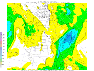
above: gfs ensemble 24 hr precip for ending Sat nite 1/30
1-25
0z GFS - no formed storm on Saturday - week stretched out lows on Friday south of OBX
6z 996 low heads just south of benchmark on Sat nite - good snow
12z further out than 6z, but still heads north southeast of benchmark. no snow
Candian - 0 and 12z runs have snow, but southeast of benchmark sat morn. weaker at 1004
Euro - 0z brushes CT going from OBX to Nova Scotia Sat to Sun. Only at 1006 as it goes by deepenint to 996 sun nite as it hits Canada. 12 z looks a little closer, but still only brushing us. A bit stronger with a 992 off Cape Cod (150 miles or so though)
UKMET 0z and 12z similar paths near benchmark, with the 12z run having a 980 low.
DGEX - 6z has no real formed low, except down at Myrtle beach heading due east. 18z has it coming further north of OBX, but then turning south. only at 1006
GFS Ensembles have it coming just southeast of BM. But spreads the precip wider than on the GFS operational, so that we get at least 6+ see picture above

1-24 Above is the 0zEuro for 1-30 with the storm right off cape cod. Canadian was same. The 12z runs also had similar look with storm just a tad further east.
0z gfs has no storms at all
6z gfs goes off the delmarva - bringing snow
12z gfs is south of hatteras
ukmet looks south, but hard to tell this far out
6z dgex is off hatteras
Saturday, January 23, 2010
Snow drought continues until maybe the 30th
1-23
While we will get some much needed rain on Sun nite, the snow drought for January continues, with the end perhaps coming on the last day of the month. Cold air returns on tuesday and continues indefinitely. Bad part is that the euro and every other gfs run, and the canadian, have the storm on 1/30 going to our south. Canadian is closest 6z run gfs has it hitting us square, but perhaps warming up enough for rain. Wait, this just in...
18z gfs run today now takes that low on friday to Cleveland and up into Canada.
12z gfs run has the low on friday south of Birmingham and goes out off Hatteras
6z has over knoxville and exiting off the Delmarva
0z has it south of Birmingham on friday and exiting south of Hatteras
thats messed up.
Pix of the maps for 0z sat are included here


Even worse - the gfs ensembles have no formed low pressure either next friday or saturday anywhere east of t he miss.
While we will get some much needed rain on Sun nite, the snow drought for January continues, with the end perhaps coming on the last day of the month. Cold air returns on tuesday and continues indefinitely. Bad part is that the euro and every other gfs run, and the canadian, have the storm on 1/30 going to our south. Canadian is closest 6z run gfs has it hitting us square, but perhaps warming up enough for rain. Wait, this just in...
18z gfs run today now takes that low on friday to Cleveland and up into Canada.
12z gfs run has the low on friday south of Birmingham and goes out off Hatteras
6z has over knoxville and exiting off the Delmarva
0z has it south of Birmingham on friday and exiting south of Hatteras

thats messed up.
Pix of the maps for 0z sat are included here


Even worse - the gfs ensembles have no formed low pressure either next friday or saturday anywhere east of t
 he miss.
Tuesday, January 19, 2010
Jan 22nd minor storm
1/23 - yeah that one went way south of us.
1-19
While the gfs does its typical run of the storm out to sea, CMC has this grazing CT and so does the Euro. All models have enough cold air in place and the high looks pretty good to the north.
Gfs ensembles leaning north to bring precip into the area, but not very much at this point.
Looks to be more coastal, but with marginal surface temps right along the coast, might mix with rain, with mostly snow, say between the merrit and 184 or 95 and 84. A 1-3 inch storm max right now. But, these have developed higher amounts and further north all season.
1-19
While the gfs does its typical run of the storm out to sea, CMC has this grazing CT and so does the Euro. All models have enough cold air in place and the high looks pretty good to the north.
Gfs ensembles leaning north to bring precip into the area, but not very much at this point.
Looks to be more coastal, but with marginal surface temps right along the coast, might mix with rain, with mostly snow, say between the merrit and 184 or 95 and 84. A 1-3 inch storm max right now. But, these have developed higher amounts and further north all season.
Tuesday, January 12, 2010
1-12 and still dry over CT


Danbury remains in the desert with .11 of precip in the next two weeks. However rest of country starts to moisten
Sunday, January 10, 2010
19th storm
1-19 - got half inch of snow per dxr - was in vt where we got 5". only got .12 output too. Still way dry.
1-16 morning - ct right on snow line aloft , but temps above freezing per surface maps.
Ukmet still well north, all rain for ct. CMC well north, all rain. Euro brings snow line down towards the end of the storm.
1-15 12z runs - Euro now has 850 line over CT, before after and during. 540 line is still too far north
CMC - starts with the 850 line in Canada on Sunday, but collapses it on Monday down to MA/CT
UKMET - brings 850 line down to MA
GFS - brings 850 line down to CT (and is much faster)
NAM - brings 850 down to S. VT and is fast like GFS
Most interesting is that all the models, except the NAM, bring the low just south of LI, nw of the benchmark, which would normally result in a rain event at the shore and snow inland, sometimes way inland. So it may not be as strange of an event now that the low has shifted north. Nam has it going over CT.
1-15 - all models have temps at 850 well to our north, with US models trying to cool things for snow. With a low going to our south, in the coldest time of the year (ave high 35 here), and the temp the day before only 36, this should be snow. UKMET and CAN has 850 line in Canada, Euro in Northern New ENgland, 0z NAM drops it down over us, 0z GFS drops it just south of CT. 6z NAM makes it only South to MA. GFS has it splitting CT. Looks like rain to wet snow event.


1/13 - Euro still has it, although warm and weak. GFS has it in a major way now at 102 hrs. See pictures above of that. Should be rain to snow event, or all snow for much of CT. CAN still out to sea.
1/12 The GFS, UKMET and CAN all have storm going way south (18z gfs is closer though). Euro has it just making it north enough for CT, but ironically, rain, at least to start. Key is the trough coming behind it and the GFS kicking a low out ahead. Not sure why this is underlined. See still dry post for pic of output from storm, or lack thereof.
1-10
GFS ensembles, 18z operational, and jma have storm coming up the coast. Earlier runs out to sea, adjusting north. Will it go even further north? Precip output for this run was 1.25 over CT.
1-16 morning - ct right on snow line aloft , but temps above freezing per surface maps.
Ukmet still well north, all rain for ct. CMC well north, all rain. Euro brings snow line down towards the end of the storm.
1-15 12z runs - Euro now has 850 line over CT, before after and during. 540 line is still too far north
CMC - starts with the 850 line in Canada on Sunday, but collapses it on Monday down to MA/CT
UKMET - brings 850 line down to MA
GFS - brings 850 line down to CT (and is much faster)
NAM - brings 850 down to S. VT and is fast like GFS
Most interesting is that all the models, except the NAM, bring the low just south of LI, nw of the benchmark, which would normally result in a rain event at the shore and snow inland, sometimes way inland. So it may not be as strange of an event now that the low has shifted north. Nam has it going over CT.
1-15 - all models have temps at 850 well to our north, with US models trying to cool things for snow. With a low going to our south, in the coldest time of the year (ave high 35 here), and the temp the day before only 36, this should be snow. UKMET and CAN has 850 line in Canada, Euro in Northern New ENgland, 0z NAM drops it down over us, 0z GFS drops it just south of CT. 6z NAM makes it only South to MA. GFS has it splitting CT. Looks like rain to wet snow event.


1/13 - Euro still has it, although warm and weak. GFS has it in a major way now at 102 hrs. See pictures above of that. Should be rain to snow event, or all snow for much of CT. CAN still out to sea.
1/12 The GFS, UKMET and CAN all have storm going way south (18z gfs is closer though). Euro has it just making it north enough for CT, but ironically, rain, at least to start. Key is the trough coming behind it and the GFS kicking a low out ahead. Not sure why this is underlined. See still dry post for pic of output from storm, or lack thereof.
1-10
GFS ensembles, 18z operational, and jma have storm coming up the coast. Earlier runs out to sea, adjusting north. Will it go even further north? Precip output for this run was 1.25 over CT.

-
 Without any real cold air around, this one looks to be mostly rain for CT. The models are not in alignment: GFS - furthest south with low ov...
 -
 11/27 update - happy thanksgiving. GFS has gone from major noreaster, to huge cutter to lakes and now has a minor clipper system sinking do...
 -
 0z above with explosive development 12 z below prior to explosive development While the October snow was certainly impressive and rare, a r...