11-26 0z run of euro at 232 does show snow on the ground for 12/5. Looks like a waa event, again.
6z gfs shows the same storm sliding south of us, then getting blocked out at sea and coming west, to give us up to 10" on the 6th, but I gotta say that looks weird. The first plowable snow is on the 9th-10th. Looks major and more likely than the prior solution. 0z shows the storm on the 5th sliding under us and out to sea, but does give us measurable snow. My guess is that becomes a cutter to the lakes.
12z Euro took weak low out under us on 12/5, missing us. 12z and 18z runs of gfs show weak low, but giving us a few inches. Then, the storm loops and comes sw from maine bringing more, but not much.
11-23 the side caption still has a map similar to today's gfs for 12/2 - 12/3 as being the first real covering of snow. But plowable (over 2") snow has not shown up yet as the pattern is going from trough to ridge, cold to warm and back again. Eventually we will get to a point where it is a warm advection snow set up, but until then its kinda dull. Although the mets are getting real excited for December.
There is a hint of a storm on the 5th, and again on the 8th which may bring snow, but its not showing up on the snow map.
Tuesday, November 23, 2010


Monday, November 15, 2010
Thanksgiving
11/26 - Thanksgiving result - snow sleet and rain fell - temps started at 42 and dropped to 37 on way to NJ. But there was definitely snow while we were in westchester, despite the airport not reporting it. West of Roseland reported grounds being covered and up to 3" in E PA.
11/23 - A tongue of subzero at 850 exists for thursday over PA, NJ, NY and W CT. If the precip arrives early, it could be as snow as temps are to be in the lower 20's the night before. More likely, and not discussed, is that the tongue appearing is more from evaporational cooling, so will likely take place as the precip is drying out.
11/19 - as of 7 days out, the storm originally going to our south and out to sea, is now cutting to the lakes. Should have a cold rain for Thanksgiving.
The Euro has actually gone more towards a weak low coming through wed night, just to our west, and then a double barrel low, one in the lakes, the other through the TN valley for Thurs-Fri. It just keeps the cold air at bay.
GFS 0z has a very weak front runner like the Euro, but it never makes it here. Instead it evolves into a single low going from W. PA to Northern New England.
Future- GFS has it staying cold. Euro hints at a warm up.
The snow on the map for 11/20 just came through now, a few flurries, but mostly cold rain in the form of lake effect.

Its ten days out, but the GFS is putting down a blanket of snow on Thanksgiving day. Euro is close as well. Whether is snows or rains, its going to be ugly. This is has been consistent for a few days.
Will have to look at 7 days out again.
11/23 - A tongue of subzero at 850 exists for thursday over PA, NJ, NY and W CT. If the precip arrives early, it could be as snow as temps are to be in the lower 20's the night before. More likely, and not discussed, is that the tongue appearing is more from evaporational cooling, so will likely take place as the precip is drying out.
11/19 - as of 7 days out, the storm originally going to our south and out to sea, is now cutting to the lakes. Should have a cold rain for Thanksgiving.
The Euro has actually gone more towards a weak low coming through wed night, just to our west, and then a double barrel low, one in the lakes, the other through the TN valley for Thurs-Fri. It just keeps the cold air at bay.
GFS 0z has a very weak front runner like the Euro, but it never makes it here. Instead it evolves into a single low going from W. PA to Northern New England.
Future- GFS has it staying cold. Euro hints at a warm up.
The snow on the map for 11/20 just came through now, a few flurries, but mostly cold rain in the form of lake effect.
Its ten days out, but the GFS is putting down a blanket of snow on Thanksgiving day. Euro is close as well. Whether is snows or rains, its going to be ugly. This is has been consistent for a few days.
Will have to look at 7 days out again.
Monday, November 8, 2010
First snow (non accum)
Danbury had its first snow - fell as mix of snow, sleet and rain this morning, Nov 8. Also had wind gust of 28mph during the day. Sleet and snow accumulated on grassy surfaces, along with roofs, cars, patio and patio furniture. Police reported 161 accidents across CT as a result of the wintry weather. Snow came down heavy when I left for Philly around 10am, lightened up around Katonah, but continued on and off even as I crossed the GW bridge.
And with that, the winter blog starts
I don't expect another snow event til around Thanksgiving week, which may have our first 1" accum. I am thinking more along the line of the Dec7-10 for the first plowable snow in excess of 1"
Also of interest, we had our first frost on Nov 1, but it wasn't a killer frost. That happened the next night as temps were in the 20's. It is the latest I could find for Danbury getting below 32.
And with that, the winter blog starts
I don't expect another snow event til around Thanksgiving week, which may have our first 1" accum. I am thinking more along the line of the Dec7-10 for the first plowable snow in excess of 1"
Also of interest, we had our first frost on Nov 1, but it wasn't a killer frost. That happened the next night as temps were in the 20's. It is the latest I could find for Danbury getting below 32.
Wednesday, September 8, 2010
Igor
9/21 Igors eye technically missed Bermuda to the west. Bermuda had 36 hrs of tropical storm conditions and a few gusts over 100mph. The airport readings maxed at 74mph sustained and 93mph gust. Again, another hurricane unpredictably lost strength on its way to landfall. Igor is sideswiping Newfoundland today.
9/17 - Igor still at cat 3-4 strength. Bermuda preparing for the worst. Euro swung east yesterday, but is barely west, worst case scenario, of bermuda. GFS 0z and 6z have the center just to the west (worst case) and the ensembles have a direct hit (spread is max both east and west). CMC looks to be a direct hit. Nogaps continues its misery being too far west. It goes all the way to 69w , but grazes Bermuda on the way back east. UKMET has direct hit.
NHC claims outside influenses will not affect the hurricane intensity until it reaches Bermuda. Julia is headed right toward Igor. Igor's eye isn't all that strong now, although convection is growing.
9/15 - not much time lately. Igor is still at 20N, moving slowly, barely north. Its latest advisory is at 135, but the latest ADT is at 140mph, with 941 pressure. Igor still heading mostly west, although the description by the NHC is 300 degrees, the last 3 hours are due west. Models are a bit further west, ATCF going to 65 degrees (hitting Bermuda), Hwrf similar (but recurving faster to miss bermuda to the east. GFDL must be running now ,no access. Nam still has it heading nw at 84hrs at 65 degrees. Euro goes to 67, missing Bermuda to the west. NHC hits it square as a cat 2. 18z GFS is now west to 67 and misses Bermuda to the west. UKMET has it hitting, a bit to the west though, Bermuda.
9/13 - Igor remains at 150mph, but looks to be ewr tonite, weakening slightly. Path still heading west, at times wsw. All models except ukmet call for Igor to recurve near Bermuda. We will wait until the nw motion starts before calling off any threat for the coast, but this one is modeling that it will stay out to sea. Only difference is whether its east, west or directly over Bermuda. It should weaken to three by then.
9/12
Igor went from "almost a hurricane" at 5pm on 9/11 to a 140mph cat 4 monster by 5pm on 9/12
Tracks:
ATCF models recurve as far west as 65 degrees at about 35N.
GFDL and Hwrf don't go out as far, but show a nw general path. GFDL more nnw heading towards bermuda and Hwrf more wnw to nw. Gfdl is at 62 and Hwrf at 67 - both seem to still be heading NW at that time.
Euro begins recurve at 72n/32w on 12z run. 71 degrees on the 0z run
CMC240 oz runs it straight wnw to NC/SC but stops it 200 mi or so east and turns it around
gfs - 0z just east of bermuda and out, 6z hits bermuda, 12z goes just west of bermuda. Supported by ensembles which have it just to the east, but with the most spread just to the west. 18z has it back to 67w now. Bermuda is near 65w.
Igor breached etiquette today is it skipped double dare and went to double dog dare. Named a TS at the outset. Two models on this long range:
Euro - has it heading west, and a bit wnw at day 10. Looks like it will be picked by a trough prior to landfall in US
GFS - 12z - heads it west, ridge breaks and it heads north just east of Bermuda where it gets trapped and swings into Maine.
6z - heads west, ridge breaks and heads north just eastward of Bermuda, but before it gets there hooks west again, then North, missing the island to the west
0z - clear recurve east of Bermuda
18z heads east of Bermuda, landfall in Nova Scotia
9/17 - Igor still at cat 3-4 strength. Bermuda preparing for the worst. Euro swung east yesterday, but is barely west, worst case scenario, of bermuda. GFS 0z and 6z have the center just to the west (worst case) and the ensembles have a direct hit (spread is max both east and west). CMC looks to be a direct hit. Nogaps continues its misery being too far west. It goes all the way to 69w , but grazes Bermuda on the way back east. UKMET has direct hit.
NHC claims outside influenses will not affect the hurricane intensity until it reaches Bermuda. Julia is headed right toward Igor. Igor's eye isn't all that strong now, although convection is growing.
9/15 - not much time lately. Igor is still at 20N, moving slowly, barely north. Its latest advisory is at 135, but the latest ADT is at 140mph, with 941 pressure. Igor still heading mostly west, although the description by the NHC is 300 degrees, the last 3 hours are due west. Models are a bit further west, ATCF going to 65 degrees (hitting Bermuda), Hwrf similar (but recurving faster to miss bermuda to the east. GFDL must be running now ,no access. Nam still has it heading nw at 84hrs at 65 degrees. Euro goes to 67, missing Bermuda to the west. NHC hits it square as a cat 2. 18z GFS is now west to 67 and misses Bermuda to the west. UKMET has it hitting, a bit to the west though, Bermuda.
9/13 - Igor remains at 150mph, but looks to be ewr tonite, weakening slightly. Path still heading west, at times wsw. All models except ukmet call for Igor to recurve near Bermuda. We will wait until the nw motion starts before calling off any threat for the coast, but this one is modeling that it will stay out to sea. Only difference is whether its east, west or directly over Bermuda. It should weaken to three by then.
9/12
Igor went from "almost a hurricane" at 5pm on 9/11 to a 140mph cat 4 monster by 5pm on 9/12
Tracks:
ATCF models recurve as far west as 65 degrees at about 35N.
GFDL and Hwrf don't go out as far, but show a nw general path. GFDL more nnw heading towards bermuda and Hwrf more wnw to nw. Gfdl is at 62 and Hwrf at 67 - both seem to still be heading NW at that time.
Euro begins recurve at 72n/32w on 12z run. 71 degrees on the 0z run
CMC240 oz runs it straight wnw to NC/SC but stops it 200 mi or so east and turns it around
gfs - 0z just east of bermuda and out, 6z hits bermuda, 12z goes just west of bermuda. Supported by ensembles which have it just to the east, but with the most spread just to the west. 18z has it back to 67w now. Bermuda is near 65w.
Igor breached etiquette today is it skipped double dare and went to double dog dare. Named a TS at the outset. Two models on this long range:
Euro - has it heading west, and a bit wnw at day 10. Looks like it will be picked by a trough prior to landfall in US
GFS - 12z - heads it west, ridge breaks and it heads north just east of Bermuda where it gets trapped and swings into Maine.
6z - heads west, ridge breaks and heads north just eastward of Bermuda, but before it gets there hooks west again, then North, missing the island to the west
0z - clear recurve east of Bermuda
18z heads east of Bermuda, landfall in Nova Scotia
Friday, September 3, 2010
Gaston

Sept 3rd
Gaston died earlier today, but is making a comeback with a 60% chance now of becoming, well, Gaston again. Current low shear, warm seas should redevelop. There is an area of 40kt shear between Gaston and the Islands. The above photo is from 10:30pm EDT
Sunday, August 29, 2010
But its Earl coming close now.
 Sept 3 - Earl came close to OBX and hit the BM today. Only clouds and sprinkles with a gust of 8mph. Actually its a very humid day, and the wind shift to the north didn't do a thing to solve that. The front that was "kicking Earl out" according to some is coming through weak and dry and about 6-8 hrs after Earl has passed and headed NE. Very odd storm - late on the first, it looked like a cat five with concentric eyewalls when I went to bed. Recon had winds of 199mph at 1500 feet and pressure of 927. Officially it went to 145mph, just missing cat five status. Then upon waking up, it was barely a three. And it never quite came back. Track was progged very well by JB, the GFS, Euro and the NHC. GFDL and Hwrf varied too much from the correct track to too far east. Nam got the recurve heading ene wrong, but corrected on the 2nd. Nogaps and late ukmet runs were just bad, too far west. The worst performance was the strength models which insisted Earl stay a cat 2 all the way to Ccod. I can't find a gust over 50kts all day today once it left obx. My reasoning for the weakening is too much dry air and an ill timed eyewall replacement.
 Sept 1 - lost the internet for most of the day. Back up and quick look at:
GFS 12z - over ack and real close to ccod, but not a direct hit
GFS 18z - still over ack, backs off from ccod by a few miles - puts more precip down and is much faster than euro
Euro 12z looks fairly close, but not over ack, over bm. 0z kinda stepped it around the bm, jogging east then north just missing the cape
CMC which had been the furthest east, at 12z pops in line with 12z euro, just south of ack and just nw of bm.
UKMEt, second furthest east at 0z hits obx, goes up coast and into around fall river. 12z just misses obx and nicks the cape
12z Nogaps continues its horror track, hitting obx square and wrecking everything up the coast and hitting suffolk county square. However its 0z run hits cape may and long island.
All of the above have recurve tracks that are more north than east, which based on the trough axis and front position, should be the solution. The nam on the other hand doesn't wait for the trough and relies on the weakening atlantic ridge. 12z is 100 miles east of obx and once its up to delmarva, heads more east than north. Then turns north. The 18z goes even further away from obx, 175-200 miles and still turns more east than north
Coamps (for S&G) brushes the eyewall by obx, but hits around montauk, RI/MA border
The hurricane models: gfdl keeps earl way off shore still, while the Hwrf tracks from 75/35 to the benchmark. I also like the look of their curve. They just don't brind earl close enough to obx to begin with. The NHC models have moved markedly west taking a similar path to the hwrf.
Intensity
Hwrf has earl as 80 kts (its been way underdone all along though) with the 50kt winds hitting obx. It keeps the winds at 80kts past the cape, but only ack sees 40-50 kts and the cape sees 30-40 kts. Still not a nice day. It deepens the storm from 952 to 948 as it goes east of the cape.
GFDL has it with 100-110kt winds off obx, with obx in the 60-70 kt range. By the time its over the bm, its down to barely 80kts, with 30 kt winds hitting ack and the cape. It keeps the pressure at 946 all the way up.
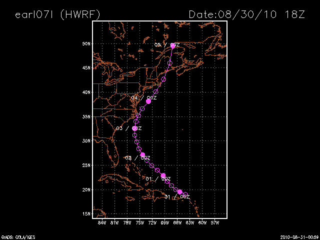
August 31 - interesting day in model worship. The GFS, Nogaps and Euro all brought Earl close to or over OBX and ACK. The wrf started that way and then shifted east on the 18z. Then went west, 20-30 miles closer to obx than on 18z run, but took it more ene out south of the bm.
All other models are still well, over 100 miles, out to sea. Local media having mixed reaction - some hyping, some saying its passing 300 miles west of obx (?). 12z GFS run was most impressive, but has backed off a bit at 18z. Feature to the right is the hwrf from yesterday
August 30
NHC has all of ct and half of nj in cone of uncertainty, with the main track just barely east of bm
18z hwrf hits obx and ack, nhc models way off coast, atcf cluster right off obx to just missing bm
18z gfs gets as far west as 75 off of sc/ga, then starts nne, about 100 mi off obx, but then heads more ne than before, going well east of bm and way east of ccod
12z gfs - about 70 miles off obx, then ne to just east of bm ,missing ack by about 70 mi and out to sea
12z eur0 - still takes it to about 70 miles off nc, then nne inside benchmark, over ack and just, barely, east of cc.
12zUKMET - takes it just n of bahamas, to 200 miles off nc/va and then hangs a 180 back out to sea.
12z cmc - same trend as ukmet - shifting east, but still within 100 mi of NC and just east of BM
0z Euro has Earl now 75 east of obx and passing within the BM, hitting ACK and CC.
0z CMC is same as Euro
6z GFS has it 120-130mi east of obx and nailing the BM
Above bring rain and wind into our area
0z UKMEt is farther east of NC, but drives more northerly into the bm and hits it square.
HRWRF takes it closer in to OBX like the euro, but curves it more ne just outside bm and missing us completely. It also barely maintains hurricane strength throughout.
GFDL keeps winds over 110kts, but it passes well east of the conus.
August 29 - NHC upgrades Earl to Hurricane with major status forecast. 5pm forecast has it moving maybe 150 miles east of NC and just to the east of the BM.
Euro - as west as 72/36 then to 68/40 on 9/3
GFS - same, with precip brushing RI/SMA
UKMET - looks like it tries to phase with Northern branch storm, comes very, very close to MD/DE up to ME (low resolution for details this far out on ewall site.
CMC - hits OBX, moves nne up over Montauk/ACK and CC
GFDL, HRWrf and ATCM models all have it recurving, coming in around 200 miles east of obx, except hrfwrf which now has it at 71/36
Intensity gfdl at 130kt+ at that time. hrwrf is at 70kt and only goes as high as 80kt.
Saturday, August 28, 2010
Fiona?
Setp 3
Fiona lost some energy into Earl, then suffered some shear from Earl. Then the upper feature kept going west, while the low level circ headed NE. Fiona looked like a airplane going down, trailing smoke behind her. She did get very close to Bermuda as a TS
August 30
GFS completely loses Fiona
Euro takes her into SC
NHC models and ATCF models all over the place
Hwrf goes up to nc/va border, hooks west and abruptly ends as trop storm
CMC keeps fiona well out to sea, east of earl and so does Gaston
August 29 - todays gfdl, hrwrf, and atcf models all are keeping fiona well out to sea
Euro has it going south of FL.
CMC moves it into the bahamas at 144
UKMET passes north of the bahamas at 144
GFS recurves well out to sea
Intensity has fiona at high ts or low hurricane
August 28 - todays 240 ecmwf has fiona at 72w 31n for 07 sep 7
gfs has earl at 72w32n on 0z sep3, with fiona swept out by earl
Fiona lost some energy into Earl, then suffered some shear from Earl. Then the upper feature kept going west, while the low level circ headed NE. Fiona looked like a airplane going down, trailing smoke behind her. She did get very close to Bermuda as a TS
August 30
GFS completely loses Fiona
Euro takes her into SC
NHC models and ATCF models all over the place
Hwrf goes up to nc/va border, hooks west and abruptly ends as trop storm
CMC keeps fiona well out to sea, east of earl and so does Gaston
August 29 - todays gfdl, hrwrf, and atcf models all are keeping fiona well out to sea
Euro has it going south of FL.
CMC moves it into the bahamas at 144
UKMET passes north of the bahamas at 144
GFS recurves well out to sea
Intensity has fiona at high ts or low hurricane
August 28 - todays 240 ecmwf has fiona at 72w 31n for 07 sep 7
gfs has earl at 72w32n on 0z sep3, with fiona swept out by earl

-
 Without any real cold air around, this one looks to be mostly rain for CT. The models are not in alignment: GFS - furthest south with low ov...
 -
 11/27 update - happy thanksgiving. GFS has gone from major noreaster, to huge cutter to lakes and now has a minor clipper system sinking do...
 -
 0z above with explosive development 12 z below prior to explosive development While the October snow was certainly impressive and rare, a r...