Wednesday, October 26, 2011
Winter prediction
For DXR, Dec 1 to Feb 28, temps 1.6 above average, snow for entire season, 35-40 inches. Lots of ice and rain. 14 days with snow. 2 storms over 8".


Monday, October 24, 2011
First accumulating snow 10-27/28/29 or 30? Crazy
10-28 afternoon
12z GFS pulls a bit in closer to land, has a 1004 low going to 996 of ACY in 6hrs. The -5isotherm is ok over the below target area and should support at least 10:1 snow ratio. The 0 850 isotherm remain just south of LI over Monmouth county and follows the tpke to PHL, until later when it crashes in. Areas north of this line will see a mix or all snow. South will be a rain to snow. The 0 line does not make it to the coast, so I will not see much snow in Ocean city. GFS bullseyse for snow is Springfield Ma, where it has 18 inches.
12z Nam is much more aggressive with the cold air aloft. The thickness line is well clear of dxr. the -5 isotherm is over entire ct and makes it to the coast, so according to it, there will be snow along the shore. Nam targets Sussex and Springfield MA with 12-18 inches. It also brings accumlulating snows to the shore.
12z Euro has 1.6 inches of precip for DXR. All falling with thicknesses that support mostly snow and all with the 850 temps between -4.6 and -5.7. Although it has ground temps in the 40's. Not buying the ground temps as if its going to snow or rain that hard and be that cold so close to the surface, the air temps will be in the low to mid 30's.
ukmet and cmc also agree with snow for the area.
Still think 3-5 for DXR. Will be tough to accurately measure since a lot will melt and compact. Not happy as leaves finally all turned, but are still on trees.
10-28
NWS has winter storm watch out for 4-8 inches of snow. Current models all have a significant snow event for this time of year. One NAM run and GFS run brings over 8" to CT. My earlier thoughts about boundary layer temps may be misguided. This morning we had a hard freeze, ground was crunchy. With temps in the 30's most of the day and falling into the 20's tonite, should allow for ground warmth to become less of a factor. I am expecting 6-8 inches in Sussex, Orange, Ulster, Dutchess, Litchfield and North of Hartford as its possible it never rains. 3-5 inches in Danbury, Northern Westchester, Putnam, Rockland. 1-3 around the Essex, White Plains and Bergen counties. I'm undercutting all mets at this point since in areas south of 84, this is unprecedented in my lifetime. It is believable for Sussex and Litchfield ctys, perfect storm hit them. So climatology is keeping me from making a call that its a big storm for everyone. the 0z Euro is nuts bringing heavy snows into the city and almost to the coast- see below. The entire state of Ct is below -5 at 850 at this time. Snow ratios should be 10:1 if thats the case.
10-27 12 GFS comes around to Euro idea, Euro maintains coastal track, see GFS snow map below. UKMET agrees, CMC is farthest east. NAM misses the area completely, but brushes SNJ and RI
10-26 Euro pushed east a bit, then came back west. JMA still supports large storm, euro not as bad, but still snow on Sat. GFS has snow on Sat as well, but mostly to our south. 18z nam way out to sea with no precip.
10-25 update - Euro hanging on, but losing support
Mets and models catching onto possible snow in the area thurs nite. Still a coating or no accum is likely.
Saturday is another problem. Euro continues to blow up a storm and have it snow. 0z ukmet supports it, 0z cmc brushes east ct and south nj with snow, but more out to sea (ots). DGEX and 0,6 and 12z GFS don't phase the storms and are suffering from interference from Rina. Thus keeping one storm out to sea and the other goes north, or not even showing a shortwave. 12z cmc is way out to sea, and can't tell on the ukmet, but also looks ots.
JMA is still bullish like Euro
10-24 afternoon update.
JMA puts a 990 low off the cape on sunday, with 850 temps supporting snow (no word on ground temps though).
ukmet has nice low to our south and high right where it needs to be on the 0z run, but the 12z bombs one up the coast (no guidance as to temps yet but the 540 height is there indicating cold enough aloft).
12z cmc brings the 0/850 line over us thurs morn and keeps it to the south as waves move over on thurs and fri, but keeps the precip south as well. Funny if SNJ got snow before us. On sat it blows up another wave into a good low, but right over PHL, resulting in rain to snow for DXR.
12zeuro brings the 850 line south of us on fri, with some residual flurries. But really winds up the storm off the coast on Sat, with serious snow, based on the 850 temps. By Sat, the ground may be closer to 35 or 38 degrees if it gets that cold on thurs. The low on Sun morn is off CCod around 986mb
So all models but CMC have a good storm brewing, CMC is just too inland.
NWS is not on this right now. Will see if they mention later though.

10-24
I had been thinking mid november for the first 1" snow on the ground, with the first flakes in the beginning of Nov.
This mornings gfs has a shocking prediction of snow on the ground for the 28th! First run I've seen with over 1" The 0z Euro kinda supports it too, either the 27th or 30th. However, we haven't even had a frost yet, so it will really have to snow hard as to not melt as the ground temps are probably closer to 50. So I will say that it will not accumulate over an inch due to ground warmth, but if it were two weeks later, it would have had a better chance.
12z GFS pulls a bit in closer to land, has a 1004 low going to 996 of ACY in 6hrs. The -5isotherm is ok over the below target area and should support at least 10:1 snow ratio. The 0 850 isotherm remain just south of LI over Monmouth county and follows the tpke to PHL, until later when it crashes in. Areas north of this line will see a mix or all snow. South will be a rain to snow. The 0 line does not make it to the coast, so I will not see much snow in Ocean city. GFS bullseyse for snow is Springfield Ma, where it has 18 inches.
12z Nam is much more aggressive with the cold air aloft. The thickness line is well clear of dxr. the -5 isotherm is over entire ct and makes it to the coast, so according to it, there will be snow along the shore. Nam targets Sussex and Springfield MA with 12-18 inches. It also brings accumlulating snows to the shore.
12z Euro has 1.6 inches of precip for DXR. All falling with thicknesses that support mostly snow and all with the 850 temps between -4.6 and -5.7. Although it has ground temps in the 40's. Not buying the ground temps as if its going to snow or rain that hard and be that cold so close to the surface, the air temps will be in the low to mid 30's.
ukmet and cmc also agree with snow for the area.
Still think 3-5 for DXR. Will be tough to accurately measure since a lot will melt and compact. Not happy as leaves finally all turned, but are still on trees.
10-28
NWS has winter storm watch out for 4-8 inches of snow. Current models all have a significant snow event for this time of year. One NAM run and GFS run brings over 8" to CT. My earlier thoughts about boundary layer temps may be misguided. This morning we had a hard freeze, ground was crunchy. With temps in the 30's most of the day and falling into the 20's tonite, should allow for ground warmth to become less of a factor. I am expecting 6-8 inches in Sussex, Orange, Ulster, Dutchess, Litchfield and North of Hartford as its possible it never rains. 3-5 inches in Danbury, Northern Westchester, Putnam, Rockland. 1-3 around the Essex, White Plains and Bergen counties. I'm undercutting all mets at this point since in areas south of 84, this is unprecedented in my lifetime. It is believable for Sussex and Litchfield ctys, perfect storm hit them. So climatology is keeping me from making a call that its a big storm for everyone. the 0z Euro is nuts bringing heavy snows into the city and almost to the coast- see below. The entire state of Ct is below -5 at 850 at this time. Snow ratios should be 10:1 if thats the case.

10-27 12 GFS comes around to Euro idea, Euro maintains coastal track, see GFS snow map below.
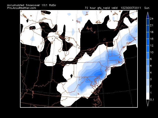 UKMET agrees, CMC is farthest east. NAM misses the area completely, but brushes SNJ and RI
10-26 Euro pushed east a bit, then came back west. JMA still supports large storm, euro not as bad, but still snow on Sat. GFS has snow on Sat as well, but mostly to our south. 18z nam way out to sea with no precip.
10-25 update - Euro hanging on, but losing support
Mets and models catching onto possible snow in the area thurs nite. Still a coating or no accum is likely.
Saturday is another problem. Euro continues to blow up a storm and have it snow. 0z ukmet supports it, 0z cmc brushes east ct and south nj with snow, but more out to sea (ots). DGEX and 0,6 and 12z GFS don't phase the storms and are suffering from interference from Rina. Thus keeping one storm out to sea and the other goes north, or not even showing a shortwave. 12z cmc is way out to sea, and can't tell on the ukmet, but also looks ots.
JMA is still bullish like Euro
10-24 afternoon update.
JMA puts a 990 low off the cape on sunday, with 850 temps supporting snow (no word on ground temps though).
ukmet has nice low to our south and high right where it needs to be on the 0z run, but the 12z bombs one up the coast (no guidance as to temps yet but the 540 height is there indicating cold enough aloft).
12z cmc brings the 0/850 line over us thurs morn and keeps it to the south as waves move over on thurs and fri, but keeps the precip south as well. Funny if SNJ got snow before us. On sat it blows up another wave into a good low, but right over PHL, resulting in rain to snow for DXR.
12zeuro brings the 850 line south of us on fri, with some residual flurries. But really winds up the storm off the coast on Sat, with serious snow, based on the 850 temps. By Sat, the ground may be closer to 35 or 38 degrees if it gets that cold on thurs. The low on Sun morn is off CCod around 986mb
So all models but CMC have a good storm brewing, CMC is just too inland.
NWS is not on this right now. Will see if they mention later though.

10-24
I had been thinking mid november for the first 1" snow on the ground, with the first flakes in the beginning of Nov.
This mornings gfs has a shocking prediction of snow on the ground for the 28th! First run I've seen with over 1" The 0z Euro kinda supports it too, either the 27th or 30th. However, we haven't even had a frost yet, so it will really have to snow hard as to not melt as the ground temps are probably closer to 50. So I will say that it will not accumulate over an inch due to ground warmth, but if it were two weeks later, it would have had a better chance.
Thursday, October 13, 2011
First snows! 10/29?
10/26 - Still looks like a slight chance that some snow will sneak in. Upton has removed completely from forecast and its a matter of timing. A insignificant event, although may be the first flakes on 10/27. NAM and GFS are fairly bullish on snow though, just a dusting though.
10/24
Euro went nuts on the 0z run last nite with a storm on thurs nite putting flakes in the air and then bringing another storm up the coast on sat nite, with more snow in the air. 0z GFS is weaker and flatter on the first and keeps the second well off coast, but does put flurries in. 6z GFS has more snow - pix below. 0z gfs does follow with a potent storm, accumulating snow for the 4th. See the first accum post for what the 6z gfs shows
aside note - no real frost yet this year, just a lite scattered one on the 7th

Euro

GFS
10/21
No go for the 21st, but real promising for around the 29th. Yesterday's euro had the trough lifting out with the gfs having the trough digging in (btw - euro had no rinna, gfs and every other model did). Today, euro flips to the deep trough with rinna riding just east of the coast, drawing cold air in, as does the 0z run of the gfs. Look for snow in the air, perhaps coating if the cold air can come in. Temps are in the mid 30's though. Other issue is that this is a warm to cold air scenario which doesn't usually produce much for snow as the moisture leaves before the cold air arrives. But there is a 980 low off the coast, so....

Euro 10/21 for 10/29

GFS 10/21
------------------------------------------------------------------------------------
 GFS
 Euro
GFS and Euro agree on some snow in the region on 10/21, although not sticking and probably not making it into Danbury. Something to keep an eye on as its the first run I've seen snow on (not that I've been really looking for it yet).
10/24
Euro went nuts on the 0z run last nite with a storm on thurs nite putting flakes in the air and then bringing another storm up the coast on sat nite, with more snow in the air. 0z GFS is weaker and flatter on the first and keeps the second well off coast, but does put flurries in. 6z GFS has more snow - pix below. 0z gfs does follow with a potent storm, accumulating snow for the 4th. See the first accum post for what the 6z gfs shows
aside note - no real frost yet this year, just a lite scattered one on the 7th

Euro

GFS
10/21
No go for the 21st, but real promising for around the 29th. Yesterday's euro had the trough lifting out with the gfs having the trough digging in (btw - euro had no rinna, gfs and every other model did). Today, euro flips to the deep trough with rinna riding just east of the coast, drawing cold air in, as does the 0z run of the gfs. Look for snow in the air, perhaps coating if the cold air can come in. Temps are in the mid 30's though. Other issue is that this is a warm to cold air scenario which doesn't usually produce much for snow as the moisture leaves before the cold air arrives. But there is a 980 low off the coast, so....

Euro 10/21 for 10/29

GFS 10/21
------------------------------------------------------------------------------------
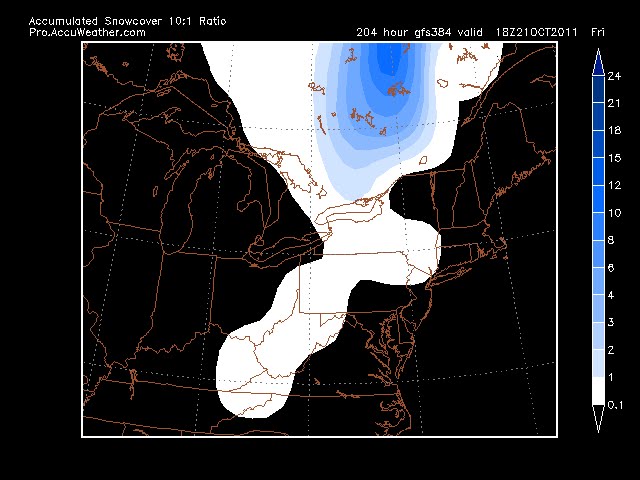 GFS
 Euro
GFS and Euro agree on some snow in the region on 10/21, although not sticking and probably not making it into Danbury. Something to keep an eye on as its the first run I've seen snow on (not that I've been really looking for it yet).
Wednesday, August 24, 2011
Irene
8-26 night
18zhwrf has shifted to the immediate coast solution - a 948 low coming of the obx at 6z, 952 at mouth of del bay at 12z and 952 over brooklyn/queens. Again, not much weakening.
18z gfdl is sending irene nw into NC, until right before it hits when it veers near beaufort, and drops from 960 to 956, perhaps tightening as it nears land. Passes over pamlico sound, exits as a 956, next to delmarva at 12z, heads north into Trenton, maintaining 956 by 18z.
0z NAM shifts west (basis for hwrf too) brings track through pamlico, back inland around ACY, up the parkway right over nyc. Keeps its strength too. 974mb. It initializes at 984, drops to 972 as it hits NC. However, winds don't exceed 50kts on that model, even over water, but don't diminish much as it heads north. Note the pressure as I write this is 950.
Regardless of the wind - predictions are for 9 inches or more of rain.
8-26 evening
12 euro puts a 960 low from inland of hatteras, back over water maintains it until cape may. Follows parkway up through nj into hudson valley, reaching our area as a 972 low
GFDL came east to the Del river. HWrf went east hitting twin forks. GFS, NAM still off nj coast into LI. UKMEt up del river like gfdl
None of the models have this weakening (or strenghtening for that matter).
But unless this monster reforms, wrapping itself up along the coast, I am doubtful we get much here with the wind, certainly not hurricane sustained. Rain, however, won't go away. I'd be surprised if we wake up to a hurricane warning. Rapid dissipation flag has been on today on the ATD site, and its been flagged for weakening all day too. You can see the bands of dry air working into the center, effectively killing this.
8-26 - First looks shows NAM is furthest east with landfall on long island. GFS 6z goes right up the nj coast, also hitting LI closer to nyc. Euro shifted east, but still has lp going right up the nj coast, over nyc and over dxr. UKMET takes it up Ches bay, up the Del river. CMC takes it up the coast, but veers east, hits LI and East CT. HWRF takes it over OBX, just off ACY, over New Haven. GFDL is still taking it over DC through East PA. Mid range model consesus is just off OBX, ACY and straight up over LI and into CT.
I am still leaning east, keeping NJ out of major surge and major wind, but its so close and being off by just a little can be devastating. DXR may still see the eye, but it will likely go inland between Bridgeport (BDR) and new haven (NHO). Strength is another problem. As of last night it was really getting its act together, with pressures dropping and eye clearly distinct. But instead, the NHC dropped it to a cat 2. As of this morning, I don't see any strengthening either. So at this point, talk of a cat two hitting LI is over forecasting. Its not the fastest moving storm and its not supposed to pick up speed until it passes, so there is a lot of time for this to weaken as it goes up the coast. Mitigating that are water temps which marginally support maintaining strength at least to ACY. Low Cat one is my call for now, over Nassau cty. I don't expect sustained winds anywhere over 80mph. However, gusts can still get to over 100mph. There will be a lot, 5-10 inches of rain over NJ, NYC and Orange,Westchester.
But as I said, the storm moving 30 miles further west, which is only about the diameter of the 2 eyes, means landfall in ACY and winds extend hundreds of miles out.
8-25 late evening. NWS still has us with just about a direct hit on the metro area. While I still favor a further eastern trend, its a bit unnerving seeing the envelope still being eastern ct and eastern pa. Likewise from Morehead NC to missing OBX. 0z NAM came in with it staying offshore until long island. 18z run takes it up the nj coast and right over nyc. This is worst case scenario for us. 18z gfs hits central long island. So there is a trend east, but its going to have to take another 150 miles at this point for us to avoid heavy rain and trop force winds. Not likely.
12z euro still tracking through nj. gfdl still in eastern pa, but the 18z trended much closer to philly.

8-25 Models shift west - furthest west is GFDL and maybe 12z ukmet bringing it into NC south of OBX, over richmond, dc, between hbg and phl. Eastern side is marked by the hurricane models, most of which still keep it offshore until new england. Prepare, wait for tomorrow afternoon when all players are being sampled.
0z euro has it hitting in mid NC coast, going north over VA beach, inside Ches Bay, up del river, over trenton as a 972 LP, hurricane force winds on the jersey and delmarva coast, with 60+kt winds all through nj, east pa, ct . Rain up to 3 inches east of the track, 5+ over east pa, into central ny state, east nc, east va, all md.
12z nam goes right off the coast from OBX to Central LI/East LI. 6z is similar, but only goes out to Sun afternoon when its a 970 off Cape May
HWRF has storm at 100kt hitting OBX hard, going right along delmarva, up the middle of nj with 70-80kt winds hitting nyc, li by sunday afternoon, heads up hudson valley that evening with trop storm force winds hitting CT, LI, and points east. Winds are only 20kts inland, which isn't likely. LP is 934 just south of Cape May and 936 over Jackson, NJ
GFDL has storm at 110 right before slamming south of OBX, goes up to DC, with 80-90 kt winds in ches bay and along delmarva. as eye rides up east PA, 50-60kt winds hit nj and li coast.
CMC goes from OBX to ACK - almost misses completely. It starts a NE movement once it gets to the GA/FL border latitude. 12z CMC much closer to nj coast and nyc.
GFS - 0z run hits OBX, goes off Delmarva, up into NJ at Cape May, over NYC and West CT. Hits NJ coast as 966 low. 6z is a little east, 12z is further east and weaker at 972, perhaps staying just off coast of nj. Then the 12z has it go over central li and eastern ct with a sharper hook left. All runs have it lanfall in the OBX area. Surface winds aren't at hurricane force, even at the OBX, which is odd. 850mb winds are widespread 75kt+ though.
6z GFS ENS have the storm just off obx going just off the nj coast to suffolk cty and eastern ct. 12z ens about the same perhaps a bit west.
Nogaps takes 980 low just off OBX to Brooklyn/Queens fading to 985 low.
UKMET has 986 low over OBX at 72h then over Vineland at 96hr and central ME at 120. 12z run looks like the gfdl track of into wilmington, richmond, dc (but then at 72 and may be recurving).
8-24 update
12z gfs shifted west a bit. Grazes nc, 8pm sat, moves maybe 50-60 miles off ACY, then the eye clips monauk and heads over RI/MA. LP is around 960-964. Oddly it show the highest winds at 65-70kts (over ocean) with 30-40kt winds over eastern half of nj, most of ct, nyc and li. Some parts of li getting 60kts. Chatam, MA looks to be getting the 65-70kt winds. Not liking this as even at the OBX the winds offshore are not hurricane strength.
More concerning is the Euro, which is taking the storm due north from OBX and running it across NJ, NYC and up the Hudson Valley. sub 960 low.
12z gfdl brings it over the obx and up the coast, east of NYC and up RT from Bridgeport (BDR). It does so as a 928 LP, which doesn't match the winds.
12z hwrf has it just east of obx with 80kts onshore and 90 ots. Goes up across Suffolk cty, into Eastern CT. Cat one hurricane force winds along the coast the entire way up. LP from 930 off OBX to 934 before it hits LI.
All the model tracks remain inside the benchmark.
CMC/GGEM also has it brushing OBX and hitting Eastern LI and Eastern CT.
Models shifting slightly west. Will know more tomorrow as the trough that is supposed to move Irene out is going to enter North America and we get a better grip on its strength and speed.
8-24 model roundup - trending east as mentioned below.
Hurricane models - winds are in kts, sustained. Higher gusts very likely.
GFDL 6z 8-24 run has eye wall just off the obx with max winds of 120kts, sat 2pm. Takes it over the obx weakening to 100-11o kts. Moving just east of the delmarva with top winds off shore of 90-100kts. By 2pm sunday, its in delaware bay with top winds just off ac at 90-100kts. Pressure is at 928 which would either be too low for the winds, or the winds are too low for the pressure. Its over trenton at 8pm with pressure of 932, winds offshore over 70kts, with most winds inland of under ts strength. Moves over high point by 2am monday, with 40-50kt winds hitting CT coast and 60-70kts hitting long island and lake erie. Pressure at 940.
Hwrf from 6z. 2pm sat Storm just off OBX with 100-110kt winds well offshore. OBX in 90kt winds, pressure at 928. 2am Sun 100miles east of delmarva, pressure 928 winds 90-100kts, with no hurricane force winds inland. 2pm sun just south of islip, pressure 932, winds 80-90 kts hitting twin forks of li with 70kts hitting ct coast. By 8pm, its in the berkshires, 944 passing just east of dxr, looks like it goes right between bdr and nho. 60-70kt winds still hitting coast.
FWIW - DGEX takes 960 low from OBX to off acy, montauk, to the west of the cape, over boston.
12z NAM seems to take it just off OBX, headed nne in the last frame. This is a shift from the 6z run which had it passing over or just west of hatteras 2pm on sat.
Euro - 0z takes it right over OBX, off delmarva, over islip-ish, just to the east of Hartford over Ashford by 8pm Sun. Sub 960.
CMC - just nicks the OBX at 966 sat morn, heads ne and passes over Ptown at 2pm Sun, missing li, crushing the cape.
UKMET far west, over wilmington nc sat at 8pm with 990 low. moves off delmarva by about 100 miles by sunday 8pm, too slow, but would miss rest of the way if true.
JMA looks to miss obx but heads it to RI sun morn
oz and 6z gfs grazes obx, looks to hit RI hard, passing just west of the cape, crushing it.
Most other hurricane models are taking it just east of obx over or inside the bm.
8-24
I go on vacation and a cat 3 storm pops up with us in the center of the cone of uncertainty.

The first is worst case for wind as it passes to our west. Although the more inland route should diminish winds to a cat 1 or strong TS. The direct hit scenario on cone 2 is more rain than wind, although we would still see trop storm winds.
I'm not in either camp. My early guess that the eye passes just E of OBX and SE of Cape Cod. We'll watch the models and the cone shift steadily east. Only problem facing us is if the storm moves quicker than currently forecast. Two problems with that - first, it gets here before the trough can push it out. Second, it keeps its strength farther north.
18zhwrf has shifted to the immediate coast solution - a 948 low coming of the obx at 6z, 952 at mouth of del bay at 12z and 952 over brooklyn/queens. Again, not much weakening.
18z gfdl is sending irene nw into NC, until right before it hits when it veers near beaufort, and drops from 960 to 956, perhaps tightening as it nears land. Passes over pamlico sound, exits as a 956, next to delmarva at 12z, heads north into Trenton, maintaining 956 by 18z.
0z NAM shifts west (basis for hwrf too) brings track through pamlico, back inland around ACY, up the parkway right over nyc. Keeps its strength too. 974mb. It initializes at 984, drops to 972 as it hits NC. However, winds don't exceed 50kts on that model, even over water, but don't diminish much as it heads north. Note the pressure as I write this is 950.
Regardless of the wind - predictions are for 9 inches or more of rain.
8-26 evening
12 euro puts a 960 low from inland of hatteras, back over water maintains it until cape may. Follows parkway up through nj into hudson valley, reaching our area as a 972 low
GFDL came east to the Del river. HWrf went east hitting twin forks. GFS, NAM still off nj coast into LI. UKMEt up del river like gfdl
None of the models have this weakening (or strenghtening for that matter).
But unless this monster reforms, wrapping itself up along the coast, I am doubtful we get much here with the wind, certainly not hurricane sustained. Rain, however, won't go away. I'd be surprised if we wake up to a hurricane warning. Rapid dissipation flag has been on today on the ATD site, and its been flagged for weakening all day too. You can see the bands of dry air working into the center, effectively killing this.
8-26 - First looks shows NAM is furthest east with landfall on long island. GFS 6z goes right up the nj coast, also hitting LI closer to nyc. Euro shifted east, but still has lp going right up the nj coast, over nyc and over dxr. UKMET takes it up Ches bay, up the Del river. CMC takes it up the coast, but veers east, hits LI and East CT. HWRF takes it over OBX, just off ACY, over New Haven. GFDL is still taking it over DC through East PA. Mid range model consesus is just off OBX, ACY and straight up over LI and into CT.
I am still leaning east, keeping NJ out of major surge and major wind, but its so close and being off by just a little can be devastating. DXR may still see the eye, but it will likely go inland between Bridgeport (BDR) and new haven (NHO). Strength is another problem. As of last night it was really getting its act together, with pressures dropping and eye clearly distinct. But instead, the NHC dropped it to a cat 2. As of this morning, I don't see any strengthening either. So at this point, talk of a cat two hitting LI is over forecasting. Its not the fastest moving storm and its not supposed to pick up speed until it passes, so there is a lot of time for this to weaken as it goes up the coast. Mitigating that are water temps which marginally support maintaining strength at least to ACY. Low Cat one is my call for now, over Nassau cty. I don't expect sustained winds anywhere over 80mph. However, gusts can still get to over 100mph. There will be a lot, 5-10 inches of rain over NJ, NYC and Orange,Westchester.
But as I said, the storm moving 30 miles further west, which is only about the diameter of the 2 eyes, means landfall in ACY and winds extend hundreds of miles out.
8-25 late evening. NWS still has us with just about a direct hit on the metro area. While I still favor a further eastern trend, its a bit unnerving seeing the envelope still being eastern ct and eastern pa. Likewise from Morehead NC to missing OBX. 0z NAM came in with it staying offshore until long island. 18z run takes it up the nj coast and right over nyc. This is worst case scenario for us. 18z gfs hits central long island. So there is a trend east, but its going to have to take another 150 miles at this point for us to avoid heavy rain and trop force winds. Not likely.
12z euro still tracking through nj. gfdl still in eastern pa, but the 18z trended much closer to philly.

8-25 Models shift west - furthest west is GFDL and maybe 12z ukmet bringing it into NC south of OBX, over richmond, dc, between hbg and phl. Eastern side is marked by the hurricane models, most of which still keep it offshore until new england. Prepare, wait for tomorrow afternoon when all players are being sampled.
0z euro has it hitting in mid NC coast, going north over VA beach, inside Ches Bay, up del river, over trenton as a 972 LP, hurricane force winds on the jersey and delmarva coast, with 60+kt winds all through nj, east pa, ct . Rain up to 3 inches east of the track, 5+ over east pa, into central ny state, east nc, east va, all md.
12z nam goes right off the coast from OBX to Central LI/East LI. 6z is similar, but only goes out to Sun afternoon when its a 970 off Cape May
HWRF has storm at 100kt hitting OBX hard, going right along delmarva, up the middle of nj with 70-80kt winds hitting nyc, li by sunday afternoon, heads up hudson valley that evening with trop storm force winds hitting CT, LI, and points east. Winds are only 20kts inland, which isn't likely. LP is 934 just south of Cape May and 936 over Jackson, NJ
GFDL has storm at 110 right before slamming south of OBX, goes up to DC, with 80-90 kt winds in ches bay and along delmarva. as eye rides up east PA, 50-60kt winds hit nj and li coast.
CMC goes from OBX to ACK - almost misses completely. It starts a NE movement once it gets to the GA/FL border latitude. 12z CMC much closer to nj coast and nyc.
GFS - 0z run hits OBX, goes off Delmarva, up into NJ at Cape May, over NYC and West CT. Hits NJ coast as 966 low. 6z is a little east, 12z is further east and weaker at 972, perhaps staying just off coast of nj. Then the 12z has it go over central li and eastern ct with a sharper hook left. All runs have it lanfall in the OBX area. Surface winds aren't at hurricane force, even at the OBX, which is odd. 850mb winds are widespread 75kt+ though.
6z GFS ENS have the storm just off obx going just off the nj coast to suffolk cty and eastern ct. 12z ens about the same perhaps a bit west.
Nogaps takes 980 low just off OBX to Brooklyn/Queens fading to 985 low.
UKMET has 986 low over OBX at 72h then over Vineland at 96hr and central ME at 120. 12z run looks like the gfdl track of into wilmington, richmond, dc (but then at 72 and may be recurving).
8-24 update
12z gfs shifted west a bit. Grazes nc, 8pm sat, moves maybe 50-60 miles off ACY, then the eye clips monauk and heads over RI/MA. LP is around 960-964. Oddly it show the highest winds at 65-70kts (over ocean) with 30-40kt winds over eastern half of nj, most of ct, nyc and li. Some parts of li getting 60kts. Chatam, MA looks to be getting the 65-70kt winds. Not liking this as even at the OBX the winds offshore are not hurricane strength.
More concerning is the Euro, which is taking the storm due north from OBX and running it across NJ, NYC and up the Hudson Valley. sub 960 low.
12z gfdl brings it over the obx and up the coast, east of NYC and up RT from Bridgeport (BDR). It does so as a 928 LP, which doesn't match the winds.
12z hwrf has it just east of obx with 80kts onshore and 90 ots. Goes up across Suffolk cty, into Eastern CT. Cat one hurricane force winds along the coast the entire way up. LP from 930 off OBX to 934 before it hits LI.
All the model tracks remain inside the benchmark.
CMC/GGEM also has it brushing OBX and hitting Eastern LI and Eastern CT.
Models shifting slightly west. Will know more tomorrow as the trough that is supposed to move Irene out is going to enter North America and we get a better grip on its strength and speed.
8-24 model roundup - trending east as mentioned below.
Hurricane models - winds are in kts, sustained. Higher gusts very likely.
GFDL 6z 8-24 run has eye wall just off the obx with max winds of 120kts, sat 2pm. Takes it over the obx weakening to 100-11o kts. Moving just east of the delmarva with top winds off shore of 90-100kts. By 2pm sunday, its in delaware bay with top winds just off ac at 90-100kts. Pressure is at 928 which would either be too low for the winds, or the winds are too low for the pressure. Its over trenton at 8pm with pressure of 932, winds offshore over 70kts, with most winds inland of under ts strength. Moves over high point by 2am monday, with 40-50kt winds hitting CT coast and 60-70kts hitting long island and lake erie. Pressure at 940.
Hwrf from 6z. 2pm sat Storm just off OBX with 100-110kt winds well offshore. OBX in 90kt winds, pressure at 928. 2am Sun 100miles east of delmarva, pressure 928 winds 90-100kts, with no hurricane force winds inland. 2pm sun just south of islip, pressure 932, winds 80-90 kts hitting twin forks of li with 70kts hitting ct coast. By 8pm, its in the berkshires, 944 passing just east of dxr, looks like it goes right between bdr and nho. 60-70kt winds still hitting coast.
FWIW - DGEX takes 960 low from OBX to off acy, montauk, to the west of the cape, over boston.
12z NAM seems to take it just off OBX, headed nne in the last frame. This is a shift from the 6z run which had it passing over or just west of hatteras 2pm on sat.
Euro - 0z takes it right over OBX, off delmarva, over islip-ish, just to the east of Hartford over Ashford by 8pm Sun. Sub 960.
CMC - just nicks the OBX at 966 sat morn, heads ne and passes over Ptown at 2pm Sun, missing li, crushing the cape.
UKMET far west, over wilmington nc sat at 8pm with 990 low. moves off delmarva by about 100 miles by sunday 8pm, too slow, but would miss rest of the way if true.
JMA looks to miss obx but heads it to RI sun morn
oz and 6z gfs grazes obx, looks to hit RI hard, passing just west of the cape, crushing it.
Most other hurricane models are taking it just east of obx over or inside the bm.
8-24
I go on vacation and a cat 3 storm pops up with us in the center of the cone of uncertainty.


The first is worst case for wind as it passes to our west. Although the more inland route should diminish winds to a cat 1 or strong TS. The direct hit scenario on cone 2 is more rain than wind, although we would still see trop storm winds.
I'm not in either camp. My early guess that the eye passes just E of OBX and SE of Cape Cod. We'll watch the models and the cone shift steadily east. Only problem facing us is if the storm moves quicker than currently forecast. Two problems with that - first, it gets here before the trough can push it out. Second, it keeps its strength farther north.
Wednesday, July 13, 2011
Real Heat Wave possible
The excess moisture in the ground from spring until now has been using up a lot of the suns energy, with evaporation causing some cooling. However, once that moisture is gone, then the real heat waves can get started. So far this year the high in DXR is 90. IMBY its 89. However, the last few days were in the upper 80's and no rain as dry fronts came through. This sets the stage as we cycle through another nice pattern, leading to the heat wave which the Euro shows for the end of next week. And while that ridge centered over VA brings us the heat, it will also open the Gulf up for activity, although the Euro shows no LP developing at this time. GFS also shows heat wave potential, but no tropical activity
Wednesday, June 29, 2011
Hurricane Season
Hurricane season begins June 1, but we had to wait until June 28 for our first Tropical Storm. As mentioned in the previous post, conditions looked good for development, and sure enough it happened. Arlene should remain a TS and move into Mexico early tomorrow.
As a fun note, our 18th storm will be named Sean. Not thinking we will get that far though.
As a fun note, our 18th storm will be named Sean. Not thinking we will get that far though.
Saturday, June 25, 2011
May/June
After a 1.3+ normal May, with above normal precip, we expected a cool June. Well, we got our first 90 reading in June, on the 8th, forcing Danbury schools to dismiss early. Strong storms following the "heat wave" (two days of temps at 90), brought down trees and power lines, forcing the closing of area schools completely (except Danbury).
June is running below normal temp wise, despite the few days of heat at the start. We've been locked into a pattern where an upper low sits over the lakes, keeping it cool with on and off rain. In the 14 days since the heatwave broke, only 4 had no rain, with no above normal highs.
First signs of hurricane season showing up on the GFS with a TS making landfall around the TX/LA area on the 7th-8th. Not seen on the euro though, not yet at least
June is running below normal temp wise, despite the few days of heat at the start. We've been locked into a pattern where an upper low sits over the lakes, keeping it cool with on and off rain. In the 14 days since the heatwave broke, only 4 had no rain, with no above normal highs.
First signs of hurricane season showing up on the GFS with a TS making landfall around the TX/LA area on the 7th-8th. Not seen on the euro though, not yet at least

-
 0z above with explosive development 12 z below prior to explosive development While the October snow was certainly impressive and rare, a r...
-
 11/27 update - happy thanksgiving. GFS has gone from major noreaster, to huge cutter to lakes and now has a minor clipper system sinking do...
-
 Without any real cold air around, this one looks to be mostly rain for CT. The models are not in alignment: GFS - furthest south with low ov...