Wednesday, September 5, 2018

Hurricane Florence day one

9-5  Beginning coverage on Florence as model consensus has it missing a trough in the Atlantic and approaching the east coast.

First, where have we been...

Here's the trend from the last 8 runs of the GFS.  Until yesterday's late run, it kept it well at sea.

This was the initial forecast

Potential Tropical Cyclone Six Discussion Number   1
NWS National Hurricane Center Miami FL       AL062018
1100 AM AST Thu Aug 30 2018

The area of low pressure that moved off the coast of Africa has
continued to become better organized, and is producing a large
area of disturbed weather with gusty winds, but currently lacks a
well-defined center.  Environmental conditions are favorable for
additional development, and a tropical depression or a tropical
storm could form an any time today or Friday.  Given the high
chances that this system could bring tropical storm conditions to a
portion of the southern Cabo Verde Islands, advisories have been
initiated on Potential Tropical Cyclone Six.  Most of the intensity
guidance calls for strengthening and so does the NHC forecast.

The system is embedded within the easterly trades and this flow
pattern will steer the disturbance toward the west or west-
northwest during the next few days.  By the end of the forecast
period, a turn toward the northwest should begin as the system
reaches a weakness in the subtropical high.  This is consistent with
the output of the global models.

FORECAST POSITIONS AND MAX WINDS

INIT  30/1500Z 12.9N  18.4W   25 KT  30 MPH...POTENTIAL TROP CYCLONE
 12H  31/0000Z 13.2N  20.1W   30 KT  35 MPH...TROPICAL DEPRESSION
 24H  31/1200Z 13.5N  22.0W   35 KT  40 MPH
 36H  01/0000Z 14.0N  24.0W   45 KT  50 MPH
 48H  01/1200Z 15.0N  27.0W   55 KT  65 MPH
 72H  02/1200Z 16.5N  33.0W   65 KT  75 MPH
 96H  03/1200Z 18.5N  38.0W   65 KT  75 MPH
120H  04/1200Z 20.0N  42.0W   65 KT  75 MPH

TD Six was hatched on the 31st on the 21z advisory
That Forecast discussion maxed it out a 70mph.
TS Florence was named in the 5 am advisory on the 1st.  
Still the 5am forecast disco kept it at under Hurricane strength through day 4

For all of Sept 3rd she remained at 65-70mph speed until the 11am advisory on the 4th when she became a hurricane. 
Hurricane Florence Advisory Number  21
NWS National Hurricane Center Miami FL       AL062018
1100 AM AST Tue Sep 04 2018

...FLORENCE BECOMES THE THIRD HURRICANE OF THE ATLANTIC SEASON...
...NO THREAT TO LAND THROUGH THE WEEKEND...


SUMMARY OF 1100 AM AST...1500 UTC...INFORMATION
-----------------------------------------------
LOCATION...19.7N 42.5W
ABOUT 1240 MI...2000 KM WNW OF THE CABO VERDE ISLANDS
ABOUT 1270 MI...2045 KM ENE OF THE LESSER ANTILLES
MAXIMUM SUSTAINED WINDS...75 MPH...120 KM/H
PRESENT MOVEMENT...WNW OR 295 DEGREES AT 12 MPH...19 KM/H
MINIMUM CENTRAL PRESSURE...990 MB...29.24 INCHES
11am ast disco mentions that the shear would knock her back to TS and then gain to H by 9th.   The track was uncertain though it clearly looked to be headed east of Bermuda and highly unlikely to make a US landfall.


This analysis didn't work out.  by 2pmAST she was 85mph.  By 11pm advisory she was 100mph.  And at 8:30 AST they advised she was Cat 3, 120mph at 961mb.  Intermediate advisory

So that takes us to the 11am Disco which adjusts the track west, but is highly uncertain, and not as far west as the models.  The analysis shows that a pocket of low shear allowed her to develop, but that the shear should increase and knock her down again.   
FORECAST POSITIONS AND MAX WINDS

INIT  05/1500Z 22.0N  45.7W  110 KT 125 MPH
 12H  06/0000Z 22.7N  47.2W  110 KT 125 MPH
 24H  06/1200Z 23.8N  49.0W  100 KT 115 MPH
 36H  07/0000Z 24.7N  50.6W   95 KT 110 MPH
 48H  07/1200Z 25.1N  52.1W   90 KT 105 MPH
 72H  08/1200Z 25.7N  54.7W   90 KT 105 MPH
 96H  09/1200Z 27.0N  57.0W   95 KT 110 MPH
120H  10/1200Z 28.5N  59.0W   95 KT 110 MPH

The GFS was really the last hold out as even the NHC ensembles are further west. 
6z NHC
12z nhc
The ukmet and euro ensembles have been onto this a few days earlier
9-3 0z euro ens

9-3 0z ukmet ens

Thoughts on the ridge/trough and other features that would affect this are at wxdisco


Saturday, July 7, 2018

Hurricane Chris


7-12  Afternoon:  Landfall has either occurred or is imminent near St. Pierre.


Morning: Chris back to TS with 70mph winds.  Heaviest precip has transferred to the northwest portion of the storm, with winds on the northeast, which is typical for storms north of 40N.  As it converts to post tropical/extra tropical, winds will expand.  Newfoundland looks to be be taking a strong hit.  Even if the eye doesn't pass over land (which it looks like it will to me) the bulk of the damage is caused ahead of the eye and the precip will be to the NW putting the island in the direct path.


7-11  Chris made it to cat 2, with max sustained winds of 105mph overnight.  Lowest pressure was 970mb.  Chris is speeding away this evening with a chance that it hits Newfoundland tomorrow evening as a TS.  Still looks strong on the satellite this evening and is currently at 90mph winds moving northeast at 25mph.  Wind field should expand as it transitions to extra tropical.


7-10  
Latest Dropsonde with surface reading at 83mph


Afternoon -waiting for upgrade.  HDOB with 984mb low and 84mph winds.  Dropsonde with near surface winds of over 95mph.


Satelite

Morning update - still a TS with winds of 70mph.  The dry air is almost mixed out on the WV loop and the radar, while at a distance, briefly showed a complete eyewall.  Would need recon to provide a radar image to confirm.


Still predicted to be a cat one at max 90 mph and no threat to land until Newfoundland (but there is time for that to change).  Wouldn't be surprised if this reached 100 mph briefly either.   Would be surprised if it went higher, or didn't exceed 75 mph.

7-9  Will the eye reform?

Evening satellite prior to nightfall.


 Chris was named in the 5am advisory yesterday.  Its expected to hang around awhile, then head northeast.  Some advisories have gotten he max winds up to 90mph 11 pm disco but the opportunity to advance is limited by the upwelling going on underneath as it stays stationary.  If it can get into warmer water, then the structure would allow it to strengthen, possibly rapidly and get to 90mph.  However, NHC has tuned it down a notch since last night.   It is coming into radar though.


A look at the satellite


7-7  This hasn't made it to official TS status yet, but recon did show smfr winds at 50mph.

Here's how it looks mid day.  Its not going anywhere for now as its stalled under  a front.  Guidance and sense says that it should stay fairly close to where it is, then move northeast. However, since its so close to land, and since guidance has changed a few times in the last day, we should still watch this.  It is currently forecast to be a hurricane and pass 40N at 65W


Thursday, July 5, 2018

Hurricane Beryl/TS Beryl

7-13  Crazy Beryl remnants firing up off the coast today. Its moving away and has little moisture to work with as its entire western half is quite dry air.


7-7 Crazy Beryl got knocked around overnight and is now exposed with no convection around its center.  They've downgraded to TS and winds of 60.


7-6  Quite the overachiever Beryl is.  NHC initial guidance was 40mph max winds in their intial disco at 11am yesterday.  In the 5pm update it was at 50mph with max winds predicted at 75mph.  An eye appeared for the 11pm update and the 5am update has it as a hurricane, 75mph with it expected to peak at 85mph.
It should track to the islands and open up afterwards.  Its strength at the time of hitting the islands is questionable at this time, but the track is pretty straightforward at least through Monday. 

Maybe a bit north or south of this but completely reasonable.  Its a very small storm, eye is 5 miles wide.  Hurricane force winds extend 10 miles from the center and TS force winds 35 miles per 5 am update.

After Monday, its expected that the storm is dissipated - some global and hurricane models show it recurving, others bring it over Jamaica.
  And if this isn't enough, there's a disturbance off the coast of the Carolinas that bears watching as this front passes. 


7-5  Tropical Depression 2 formed today.  Here's a brief look at it and the surrounding environment
Its currently very tiny, with good vorticity, low shear, but little divergence aloft and surrounded by dry air.


Low shear
Vorticity
Dry air
Divergence
 NHC also noted that the water temps aren't favorable   Cooler than normal in Hurricane Alley


Friday, June 8, 2018

Aletta

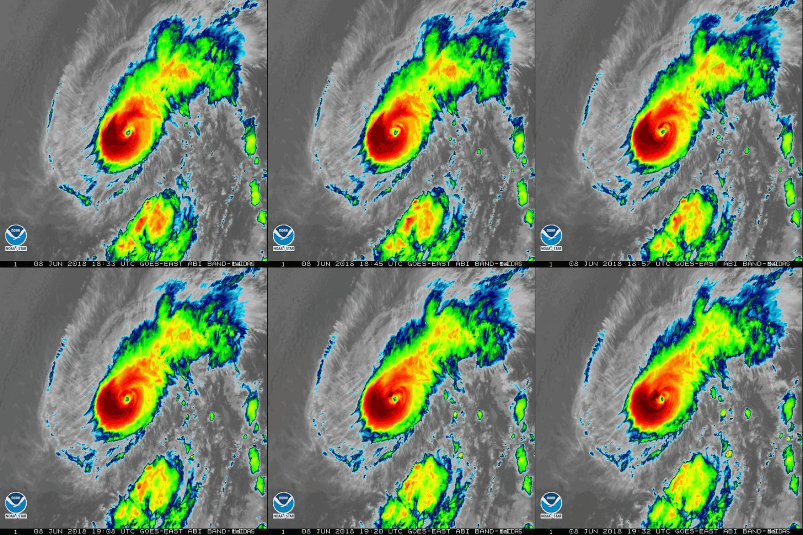
Don't usually follow pacific storms unless they threaten the US. But the image of Aletta is impressive.

Sunday, May 27, 2018

Alberto

5-28


 Station 42039 with a sustained wind of 38.9kts and gusts of 50.5 kts.

Tyndall tower seeing a few hours of minor TS storm winds of 40kts gusts to 47kts

Apalachicola buoy with TS force gusts to 40kts and sustained just under at 32kts.

Panama city buoys are still under TS for even gusts.

5-27 - been a little busy to post but as in the pre season post, we were at risk of a TS developing in the Gulf.  Alberto was named yesterday.  Currently 50mph winds.  Open on the east side, dry air keeping this from making hurricane strength.  Recon did put out a vort message with a 71mph wind, which hasn't been mentioned by the NHC

Product: Air Force Vortex Message (URNT12 KNHC)
Transmitted: 27th day of the month at 2:01Z
Agency: United States Air Force
Aircraft: Lockheed WC-130J Hercules with reg. number AF98-5308
Storm Number & Year: 01 in 2018
Storm Name: Alberto (flight in the North Atlantic basin)
Mission Number: 3
Observation Number: 08
. Time of Center Fix: 27th day of the month at 1:29:50Z
B. Center Fix Coordinates: 23°41'N 84°30'W (23.6833N 84.5000W)
B. Center Fix Location: 141 statute miles (227 km) to the WNW (286°) from Havana, Cuba.
C. Minimum Height at Standard Level: 706m (2,316ft) at 925mb
D. Estimated (by SFMR or visually) Maximum Surface Wind Inbound: 62kts (71.3mph)
E. Location of the Estimated Maximum Surface Wind Inbound: 21 nautical miles (24 statute miles) to the NNE (28°) of center fix
F. Maximum Flight Level Wind Inbound: From 101° at 39kts (From between the E and ESE at 44.9mph)
G. Location of the Maximum Flight Level Wind Inbound: 92 nautical miles (106 statute miles) to the NE (49°) of center fix
H. Minimum Sea Level Pressure: 1002mb (29.59 inHg) - Extrapolated
I. Maximum Flight Level Temp & Pressure Altitude Outside Eye: 16°C (61°F) at a pressure alt. of 757m (2,484ft)
J. Maximum Flight Level Temp & Pressure Altitude Inside Eye: 24°C (75°F) at a pressure alt. of 760m (2,493ft)


SUMMARY OF 200 PM EDT...1800 UTC...INFORMATION
----------------------------------------------
LOCATION...27.7N 84.7W
ABOUT 135 MI...220 KM W OF TAMPA FLORIDA
ABOUT 140 MI...225 KM S OF APALACHICOLA FLORIDA
MAXIMUM SUSTAINED WINDS...50 MPH...85 KM/H
PRESENT MOVEMENT...N OR 360 DEGREES AT 13 MPH...20 KM/H
MINIMUM CENTRAL PRESSURE...994 MB...29.36 INCHES
Alberto loop

Friday, May 4, 2018

Topical pre season

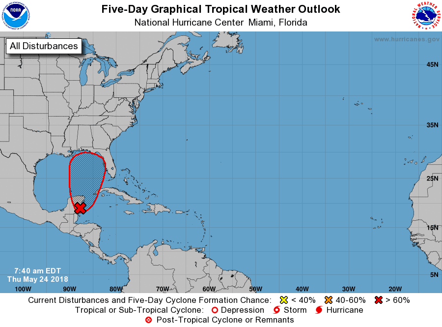
5/24 - We may have our first system this weekend along the gulf coast'

Rain is likely to be the biggest problem with Euro and GFS showing over 10"

Wind gusts under 70mph for now


5-14  NHC has downgraded this to a 30% chance of forming.


5-11  GFS has been adamant forming a low off the Yucatan and bringing it up, but it remained alone until the NAM run.


5-4

Upper low responsible for this, so not technically tropical.  Should ride up coast over next 48 hrs and either just miss or hit us on Sunday.  GOES EAST is up and running on some of its tropical sectors.

Here's a look from the Carribean sector.

Feb 25 clipper

 Got a quick 3" in 3 hours this morning Driveway was completely clear