Monday, November 30, 2009

12/5 snow


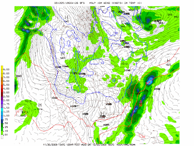
So the 12/2 storm scoots to the west of the mountains, and the cold front comes through, but the upper low is still left behind, spawning a potential light event, albeit the first one, on Saturday 12/5. The image above has the freezing line at the surface, so you can tell that its all snow and sticking.

12/2 evening update - NAM 18z has a bunch of snow, but 0z backs off to a 2-4inch amount. Euro brushes us, Can out to sea. GFS brushes us. More at the coast, still, for now.

Saturday, November 21, 2009

12-2 snow?


11/27 update - happy thanksgiving. GFS has gone from major noreaster, to huge cutter to lakes and now has a minor clipper system sinking down around the lakes and intensifying off the coast, perhaps with some snow. CAN has most snow, GFS little and Euro has nada as it takes it too close to us.


Previous posts had the gfs seeing this. The 12-2 storm looks to be tracking right over us, leading to a rain to snow storm with a few inches. A shift east 100 miles would be enough to close schools.

Kicking off the Christmas Season


While most likely a light snow, the Canadian, GFS and Euro all show conditions right for snow. Not sure the temps will be low enough to stick, or precip hard enough to stick, but should generate the right feel for kicking off the Christmas season.

Tuesday, November 17, 2009

First real snows on GFS


Here's a look at the 28th and 12/2 off the accuweather gfs site. Its only one run, but its the first with real definitive snow. I had guessed the week before Thanksgiving as the first real snow (we already had some in October), but I was off by a couple of days if this holds. It does not look possible to have a white Thanksgiving right now.

Monday, November 16, 2009

Great Nov Ridge continued


There are signs that the ridge holding most of november will be moving on out. Possibly resulting in a block as you can see the higher heights over NE Canada. Watch that ridge pump on the west coast, with trough east of hawii, to get the trough into the middle of the country. Can't tell if it will hold though.

11/21 - top shows the end of the ridge

Tuesday, November 10, 2009

The great november ridge


Euro and GFS 10 day means are showing ridging in the middle of the country, actually with higher than normal heights over almost all of the CONUS. Seems a bit overdone, and there is a shallow trough in the east, keeping us from broiling. But should indicate nice weather to the 20th or so. We'll see how this evolves as its been showing this pattern for a few days now. Keep in mind that the opposite of this is likely coming, for december.

Sunday, November 8, 2009

Wild weather watch

Keep an eye out on Ida. Should be hitting FL panhandle or AL by Monday. GFS has massive noreaster off VA on Wed/Thur. ECM 0z run concurs, but 12 z no. No other models have the noreaster at this time, but block Ida from coming north and eject her out over SC and to sea. The ECM and GFS runs are interesting as the 0 line at 850 (5000 ft) is below our area and the thickness on the ECM is right over us.

Storm 3 - could be the one! (spoiler, it was)

 2/9  Set up is an upper low over TX that heads northeast into TN valley and then transfers off the coast. At the upper levels, there's ...