Friday, November 29, 2019

12-1 and 12-2

11-30  Morning update.

Still looking at a snow, sleet, freezing rain, rain, snow event.  NAM has 2" on the front end now, here, which I think is going to be more.  But it loses the dump after it turns back to snow and adds only another inch.  This is alarming, but we'll see. 

11-29

Been watching this for a while.  Massive storm hits west coast, regenerates days later in Colorado, occludes quickly, starts moving across the country.  As the surface low weakens due to occlusion, the upper low continues across.  A warm front will be waayyy out in front of this which will kick things off.  Using GFS for depiction. Red line warm front, blue line cold front, black circle upper low,red L is surface low.
Precip starts as snow, we are 600 miles from the surface low at this time.  Typically this set up just results in a frontal passage as these lows tend to go up through the lakes. But this time there's a pretty strong low at 50N50W (called a 50/50 low, highlighted) in the way, which holds the high pressure in place and shunts the upper low SE.

This is an unusual situation - a Colorado low moving up to WI, then down to our area.  Now the warm front triggers another low, called a triple point, off NJ. 
The location and strength of this low is what will determine if we stay snow, mix or go to rain.  You can see the blue/pink/green all over the area. You can also see the Colorado low essentially dying as the triple point takes over.  But we're not done.   The upper low still is strong and heading our way.  If you end up north of this low, you get snow.  
The triple point low is slow to move out (written in L), and as the upper low moves in, its energy triggers another low to pop.  This is our snow on Monday. 

The new low becomes stacked with the upper low which almost always produces snow this time of year.  The storm moves slowly as the upper low is pretty cut off and a long duration snow event unfolds. 
This results in the GFS snow map as such.
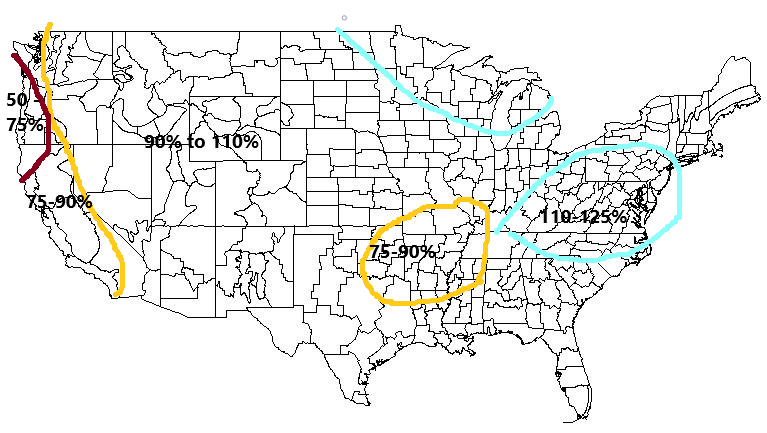
Euro, Canadian and Ukmet are all showing similar events, but timing and low placement differences lead to slightly different results.  What is not represented in the pivotal maps is whether its snow or sleet.  Freezing rain is factored out and accounted for in the bottom map.


So for right now I'm leaning for CT and NNJ north of I80  to south of the Catskills, snow to start, 2-4 inches likely and could come down hard.  Start time late morning NJ, noon for CT.  Typically this arrives earlier than modeled unless the atmosphere is super dry and it dries before making it to the ground.  By Sunday evening its a toss up.  No idea if it goes to sleet, freezing rain or rain, but temps between 5,000 and 10,000 feet (850mb and 700mb) seem to warm for almost all the area.  Monday morning that final low forms, cold air rushes in throughout the column and everyone in NJ, PA, LI, CT goes to snow.  The trick with this second part is that the snow should fall in bands, and it should vary light and heavy.  Parts north of I80 could again see anywhere from 3 to 10 inches during this time frame.   So my map looks like this for now.  I'll get better at making them soon. 
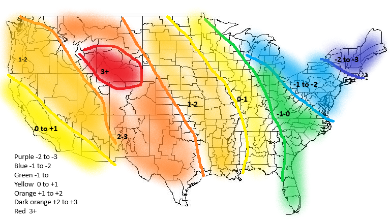
So text isn't showing up... Gray is 1-3.  Aqua is 2-4. Blue is 4-8.  Indigo is 6-12 and Purple is 12+

Thursday, November 7, 2019

11-12


11-11  LP is definitely west.  The interesting feature is that there was no rain associated with the warm front, and that as the cold front comes through, it changes over fairly quickly to snow. I always doubt snow on the back end of a frontal passage though.


11-8  Early GFS and Euro are weak and west but follow with severe cold for a day or two.


CMC also west
Navy and Ukie still have us in with snow.  Ukie actually moved east....


11-7

I'm expecting this to pull west as well after seeing the 11-9 storm do so.  The current modeling has the GFS hitting us, with the Euro going over us, but with possibly a two part storm.  If anything brings snow, its the second part of the Euro. 
0z Euro

6z GFS
WPC is between the Euro and GFS, leaning Euro positionally.  Makes sense.

Ukie similar to Euro

Closer look at Ukie

11-07

For the record, evolution of the lack of storm. GFS at hr 144 had it going to our north.


Euro came in with the first hint of snow on the 2nd
Screenshot_20191102-133146_Chrome.jpg
GFS maintained its separation of the northern storm from the southern storm on Sunday
11-4 6z gfs first hint of snow as a frontal passage

Euro still adamant on Mondays forecast

12z Euro monday starts showing signs of being too close for us to have snow
ecmwf_z500_mslp_eus_5.png
0z tuesday run for gfs has northern system still, but then loses it during the next runs


By Wed 0z its just a frontal passage

Euro still had a low going over us, but much weaker and more of a wave on a front


Sunday, November 3, 2019

Winter Forecast 2019-2020

There were no analogs that showed up what actually ended up happening. The AO remained positive the entire winter, record breaking at times.
This is the result.
Precip was a little closer. The drier and wetter parts seemed a little north, but not that poorly placed. I give myself a B on that. Missed the NW positive anomaly though.


Second attempt at a winter forecast.


ONI
Current conditions


2019
0.8
0.8
0.8
0.8
0.6
0.5
0.3
0.1


So ultimately I’m looking for a set that has us staying in the 0-0.5 range, coming from the 0.4-0.8 range. Not too many options.  1980 and 2003 are the closest. So then expand to neutral.


1980
0.6
0.5
0.3
0.4
0.5
0.5
0.3
0.0
-0.1
0.0
0.1
0.0


2003
0.9
0.6
0.4
0.0
-0.3
-0.2
0.1
0.2
0.3
0.3
0.4
0.4


That result is a warm west cold east.


1978 was a bit lower than perfect.  


1978
0.7
0.4
0.1
-0.2
-0.3
-0.3
-0.4
-0.4
-0.4
-0.3
-0.1
0.0


1990 was a good match from the staying + side  and the only warm analog
1990
0.1
0.2
0.3
0.3
0.3
0.3
0.3
0.4
0.4
0.3
0.4
0.4


1993 as well


1993
0.1
0.3
0.5
0.7
0.7
0.6
0.3
0.3
0.2
0.1
0.0
0.1


2013 was on the negative side.


2013
-0.4
-0.3
-0.2
-0.2
-0.3
-0.3
-0.4
-0.4
-0.3
-0.2
-0.2
-0.3


2014 went from neg to weak nino in the winter.


2014
-0.4
-0.4
-0.2
0.1
0.3
0.2
0.1
0.0
0.2
0.4
0.6
0.7


All up the ONI Analogs look like this from temp
And the Precip anomaly looks like


QBO  
As discovered last year, the QBO has a pretty strong correlation.  The challenge is finding the match. Last year I spotted a trend going to positive, which turned out correct, but was a fairly large assumption.  The positive phase usually lasts 11-14 months, but… 2015 phase lasted 24 months. This year I’m guessing it goes negative, sometime in the JAN time frame.  There are two years where this has happened. 97-98 and 04-05. Unfortunately neither lines up with the ONI and of course conflicts with ONI temp wise


PDO
The PDO has been fairly neutral historically speaking.


I’m going to end up with the same analogs as last year.  I think it stays between -0.3 and +0.3.  


AMO is pretty positive, moreso than last year, but its been positive for a while now, so not counting it much.


NAO is behaving as usual...so nothing to add with that, just normal cyclical activity.


AO has had a string of 5 months negative, which is unusual.  Happening only in 1980 (ONI year), 1993 (QBO year), 2014, 2010, 2008, 2004.


EPO is a challenge this year.  It behaved oddly this year, stringing nine months of consecutive monthly positives.  
I’m looking for periods in the second half of the year when it went from a string of + to neg.  1990, 1995, 2004 and 2015 match. Result is warmth CONUS wide..


Sea Ice extent was the lowest in history earlier this year and right now (blue line).  Closest comparisons are 2007, 2012 and 2016. These are all warm signals.


Similar years look like..


In looking at recent temp trend, I found the years 1980, 1984, 2000 and 2018 to be the closest Aug-Oct temp profile to this year.


That gives you the following temp profile for the following Dec-Feb


Summary - The following years showed up; 3x - 1980, 1993 and 2004.  The following years showed up 2x 1990 and 2014. This is not a strong signal as last year I only counted 3x or more.  So taking those years which show up 3x and 4x, its warm in the west, cold in the east and average precip mostly, slightly drier in the SE and NW. 


In summary the following are colder than normal indicators for the NE: ONI, AO, PDO
The following are warmer than normal:  QBO, EPO


I’m throwing out Sea Ice.  I just don’t see a correlation there anymore as every year seems to be less and less.  
I’m ignoring the NAO as its fluctuating normally, so its hard to analog against.  
The AMO is warm, but that’s not unusual lately.  However, it does factor into a slightly warmer temp forecast than analogged along the east. 


This brings us back to 5 signals, three showing cold, two warm.  QBO is normally reliable, but its hard to predict where it will be.  EPO is coming off an unusually long positive phase and I can’t put much into where its going.   ONI and PDO are pretty solid indicators, AO is unpredictable like the EPO and QBO. Thus I’m weighing ONI and PDO more heavily and the others more like 10%. 


That results in the following maps.


Years used:
ONI:  80,03 (78,90,93,13,14)
AO:  80,93,04,08,10,14
EPO: 90,95,04,15
QBO: 97,04
PDO:  77,89,04,09,17

Aug-Oct Temps: 80,84,02,18


Storm 3 - could be the one! (spoiler, it was)

 2/9  Set up is an upper low over TX that heads northeast into TN valley and then transfers off the coast. At the upper levels, there's ...