This was the result. Not bad - LI /CT stayed snow further east than expected. I'd give me an A-

1-31
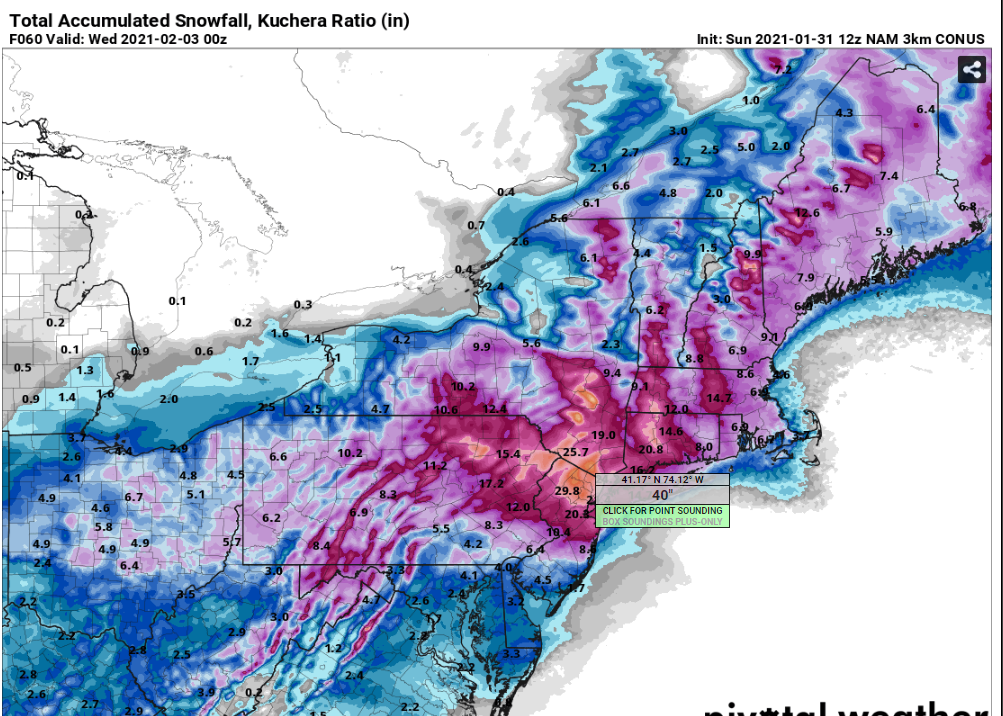
The north trend stopped, though I'm sticking with it. Still not convinced it doesn't mix NYC east and south of Trenton. There have been some breathtaking model runs today that really make me think I've underdone this. Trying to figure where the heavy band will set up is like trying to figure out where the heaviest thunderstorm will be a day before. Based on the upper level low placement, and the progged vertical velocities, I like the red area as having the most chance of being over 18" with some areas getting 24-30" in the hash. But not surprising if that hash area shifts east into Bergen or even Westchester, or if the western edge sags down a little. Mitigating things in SNJ, ELI and SECT/RI/Cape is that there will be some snow, then it mixes and rains. The low is hugging the coast for most of the heavier precip and that just brings the warm air in. We may even be dry slotted and go to freezing drizzle as far west as Fairfield County and NYC.


Or the NAM with 40"
Even the GFS as I'm drafting this came in with some big numbers

This was issued at 330 this afternoon


1-30 First snow map is below. The amounts are higher than the NWS forecast currently, but less than the highest models. The area of heavies snow is purposely north as we've seen this happen before. It is likely I will extend the 10-18 further south.


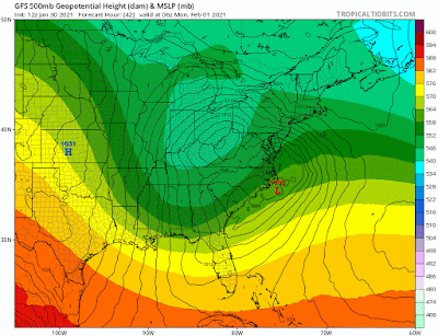
1-29 This starts off as a low coming across the country, dropping a swath of 12" across the midwest before it dies out approaching the Apps and reforms off the Carolinas. Initially the models had the transfer taking place closer to SC than NC, but that has since shifted back to the typical OBX to 40/40 benchmark track.
Complicating this standard Miller B storm is that an upper low is coming behind it which will "capture" the low and slow it down. Models having a problem trying to figure what happens to the low, with some stacking them, others putting low to the east or south. Typically the low either stacks or stays to the east and moves with the upper low. However, some models, had the low looping and heading south and then east. This is not common. Stalling, yes, but a loop that big is a red flag that the model can't figure which surface low to follow. The shaded area is the 500mb low.

Here is a more typical scenario

But today that seems to be resolved. The low is coming off NC by OBX, moving northeast (not east), getting captured by the upper low and then moving northeast.
Now that the models agree on the set up, it comes down to positioning of the lows (upper and lower) and that will remain a challenge through the weekend. Here is where we are right now with the 12z Sat model trends. You can see what we call the windshield wiper effect as the snow shifts south, then back north. This is pretty typical. Additional shifts are likely but should be less dramatic. Also note the Canadian's precip output is insane. But its not impossible, and that area may not be the one to get it.
Euro


and Canadian


.gif)
