0z nam run with it staying offshore

Barbuda and St Martin look pretty bad. The storm just went north of St. John/St Thomas which was in the Southern eye wall. BVI's took a direct hit. Bovoni had winds of 113mph before it failed. It also received over 12" of rain in two hours, and it is only half through the eyewall.


PR is the next stop, and it may end up in the southern eye wall too.
Models seem focused on either a FL/E FL or SC hit. So narrowing down between Key West and Myrtle Beach.
Euro went to the east of FL in the 0z run, but is back ashore with a direct hit on MIA at hr 102.
 |
| 0z euro winds |
 |
| 0z rain |
 |
| Gusts at MIA 12z euro |
 |
| Rain 12z euro |

Evening - this is heading toward Barbuda, St Martin, Anguila

Still no consensus


Irma remains a cat 5 hurricane and began an eye wall replacement, which is speculative at this point in time by the NHC. The 12z Euro took it over Cuba for over 24 hrs then regenerated across the straits and into Naples with a 938 pressure (the difference between the actual pressure between 12z and the euro was -32mb) which could mean a 906mb hit. Gusts were in the 120-130kt range. And it moved right up Fl, off the coast and then hit GA.

12z CMC hits the panhandle. 18z GFS makes landfall at N Myrtle Beach.

Early afternoon update
0z,6z, and 12z gfs placement

Meanwhile the CMC still goes into the gulf hitting W Fl

GFS ens mean

9- 4
Euro and GFS now both have it hitting Florida and heading north. Maybe off the coast, maybe right up the middle. Currently (8pm) its at 140mph and heading west. 943 mb.

Some pictures...
Euro gusts at 150 and 156. Well over 150mph.


HWRF 18z came north -was south of Cuba for the 6z run.


12z Euro ensembles

Moving: W at 14 mph
Min pressure: 926 mb
Max sustained: 185 mph
9-4 afternoon
Hwrf has it missing and cutting through cuba


9-3 GFS trending towards Florida. Still overblown, hopefully.

Gif of the GFS landfalls

But the craziest of them all - HMON. 250mph at 5000 feet 189mph surface


HWRF talking some sense to the HMON

Lastly the Europeans runs


9-2 GFS still nuts, latest Euro out to sea - is it a trend for the Euro or just a blip. GFS is just brutal.
 |
| 12z GFS |
 |
| 0z GFS |
 |
| 6z GFS |

and the latest EPS run

4 runs of hurricane tracks

GFS Ensembles

9-1
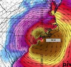
18z GFS went nuts. These gusts are anywhere from 70kts along the NJ shore to 80-90kts over LI, 80kts over CT.


In an interesting turn, the Euro pulled toward the GFS with storm up the coast (or perhaps out to sea)


6z GFS Ens Mean

8/31 evening. well this run is alarming

8/31 Irma went to 100mph at this 11am posting. Euro is taking it to the islands. GFS between CONUS and Bermuda, hitting Maine on the 12z, NC on the 6z and hooking left into Maine on the 0z
Here how close the winds are for the 12z gfs run

.Here's a look from this mornings satellite showing eye that quickly formed


12z euro

GEFS ensembles showing the difficulty of forecasting this far out

8/30
NHC initiated coverage on Irma this morning and went right to 50mph TS. Satellite is a bit clunky until it gets into Goes East territory. Here's a look


.gif)
