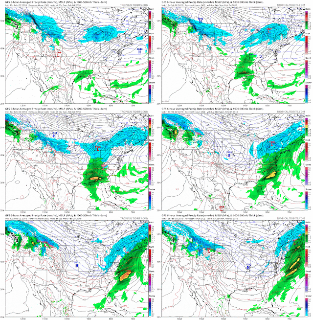
2/4 As I type, snow is observed in Caldwell ,Teterboro, NYC and White Plains. But just plain rain here. We had snow radar returns from 9am to now at 2pm, but didn't make the ground. Dew point is up above freezing now so evaporational cooling will not help. Areas in PA are getting a good on though.
2/2 Two camps on this one. GFS/NAM current camp is all the energy and focus on the clipper through the lakes and just a frontal passage for us. Perhaps some front end snow, not depicted here, but usually happens.
Vs the Euro/CMC camp where the clipper dies off and transfers energy to the southern system. This is also a common solution.
Right now, neither solution brings much in the way of snow to the immediate area, but the cmc/euro solution could change that very easily, and does bring snow to the Poconos, Catskills and Berkshires.
I'm not sure where the NWS is getting their current forecast. They have 20% chance of snow Saturday night, Snow all day on Sunday with 1-3 inches, and Sunday night turning back to snow with additional 1-3 inches.
The last two runs of the SREFs are under an inch, while yesterdays 21z and todays 3z runs are 2.5 and 3 inches. Maybe its based off the SREFs. They don't mention the source of their forecast in the AFD, just that inland areas could see 1-4 and up to 6"
1/31
This looked like a great opportunity yesterday. However, todays trends are to bring it too close to the coast for all snow. Most concerning is the NAVGEM which trended further west all day.
GFS is also trending west with precip
EPS showing large spread
ICON with a warmer storm, though low placement suggests otherwise, plus there were front end snow.
And the CMC
Its a little complicated - I'm 50% total snow for Northern Fairfield to 50% mix right now. I think things are leaning towards a mix though. Coastal areas definite mix, though snow could still accumulate.
Provide a summary of the model runs for storms which may affect Fairfield County. Not a forecast, but summary of trends, positions and precip type/amount
Wednesday, January 31, 2018
-
11/27 update - happy thanksgiving. GFS has gone from major noreaster, to huge cutter to lakes and now has a minor clipper system sinking do...
-
2/9 Set up is an upper low over TX that heads northeast into TN valley and then transfers off the coast. At the upper levels, there's ...
-
2/22 - results 5.25 inches. Snow started at 2, lasted 12 hrs with varying intensity and types of snow. Kudos for the models, weather serv...


.gif)

No comments:
Post a Comment