GFS and Fv3 on board with it being a coastal hugger too. This would still have brought us rain in January.
CMC is off on its own with a 966 low off NJ and hurricane force winds.

I really don't see how much further back it can go. Wouldn't surprise to see if bump east a bit.
Noting how the GFS starts it later. Still need to watch when this thing starts to deepen. I think the NAM is weird in that with the cold air coming in, as well as the upper level vorticity and negative tilt that it doesn't deepen the low, at least in the 18z run. It goes from 1010 to 1003 in 6 hrs (45-51) then as the upper energy hits it, to 1001,999,995,992,992,990 every three hrs. Or from 1010 to 990 in 24 hrs. Should be more.
As of now, it s 80% chance rain, 20% chance of any snow for the tristate.
Then there's the 26th
3/18
All hands on deck - as the day progressed, so did the development of this storm. Just as it should with an upper low coming down. The saving grace for snow haters is that it will be pretty warm ahead of it. Also, its trending further west.
Todays Euro runs.
The problem with the Euro is that while the 1000-500 thickness shows snow for us, its the boundary layer that's warm (thickness is a description of the temperature from surface to 18,000 ft). If the storm develops faster then there's a chance CT and RI get some snow out of this.
GFS just came on board...

UKIE was still farther east. Usually it overdoes phasing, this time it misses it. It really should be further west by the upper low.
A bunch of things can happen -it can keep drifting west, which I'm skeptical of based on where the upper low is coming in. It can form quicker or further south as the NAM is indicating, which might result in a rain to snow situation. It can bump out to sea and graze us, which might also bring some rain to snow. But I like today's maps. I think if the upper levels arrive when and where they do as depicted today, then the low forms closer into them. If those upper levels flatten out or are slower, then maybe more west, but if its too slow, not at all. If they push faster or further east, then it goes out to sea.
NAVGEM is furthest east by the UKMET which is a red flag for the UKIE. Otherwise models look lined up nicely.
3/17
We had two events to watch this week. The first was a light clipper that comes through on the 18th. Moisture is limited, but could put a dusting to an inch down in places anywhere from Baltimore to Hartford. Lately its been more focused south towards Baltimore.
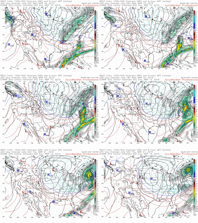
The second one is more interesting. The evolution on the models is a textbook demonstration as to how hard being a meteorologist is. I started looking at this one when the long range EPS (euro ensemble) put forth this forecast run on the 10th. Upper low coming into the midwest with a storm coming up the coast .
It further developed it to the strongest storm of the season
It then muddled around in different forms...

Then it simply disappeared for a few days until this run on the euro operational brought it back yesterday
What happens when a trough enters the US in the Great Lakes and pushes down is that a storm usually forms just in advance of it. As depecited above. Now timing and placement would still need to be ironed out, but it should happen. But then there's this mornings Euro run which is just a frontal passage with no storm at all.
Meanwhile the old GFS went from frontal passage to storm. Now note the storm is offshore, but the trough axis is pretty far back which doesn't seem right. Below is the trend showing how its developed in the last day.
Then there's the new GFS-FV3 which buries us. Its trended to the strongest storm of the season.
Leading to this result
Being 5 days out, what do you forecast..... right now snow showers is a good bet with frontal passage. But the GFS and CMC have a storm off the coast which is out of touch with the trough. NAVGEM is furthest east where it belongs.


.gif)
No comments:
Post a Comment