 Sept 3 - Earl came close to OBX and hit the BM today. Only clouds and sprinkles with a gust of 8mph. Actually its a very humid day, and the wind shift to the north didn't do a thing to solve that. The front that was "kicking Earl out" according to some is coming through weak and dry and about 6-8 hrs after Earl has passed and headed NE. Very odd storm - late on the first, it looked like a cat five with concentric eyewalls when I went to bed. Recon had winds of 199mph at 1500 feet and pressure of 927. Officially it went to 145mph, just missing cat five status. Then upon waking up, it was barely a three. And it never quite came back. Track was progged very well by JB, the GFS, Euro and the NHC. GFDL and Hwrf varied too much from the correct track to too far east. Nam got the recurve heading ene wrong, but corrected on the 2nd. Nogaps and late ukmet runs were just bad, too far west. The worst performance was the strength models which insisted Earl stay a cat 2 all the way to Ccod. I can't find a gust over 50kts all day today once it left obx. My reasoning for the weakening is too much dry air and an ill timed eyewall replacement.
 Sept 1 - lost the internet for most of the day. Back up and quick look at:
GFS 12z - over ack and real close to ccod, but not a direct hit
GFS 18z - still over ack, backs off from ccod by a few miles - puts more precip down and is much faster than euro
Euro 12z looks fairly close, but not over ack, over bm. 0z kinda stepped it around the bm, jogging east then north just missing the cape
CMC which had been the furthest east, at 12z pops in line with 12z euro, just south of ack and just nw of bm.
UKMEt, second furthest east at 0z hits obx, goes up coast and into around fall river. 12z just misses obx and nicks the cape
12z Nogaps continues its horror track, hitting obx square and wrecking everything up the coast and hitting suffolk county square. However its 0z run hits cape may and long island.
All of the above have recurve tracks that are more north than east, which based on the trough axis and front position, should be the solution. The nam on the other hand doesn't wait for the trough and relies on the weakening atlantic ridge. 12z is 100 miles east of obx and once its up to delmarva, heads more east than north. Then turns north. The 18z goes even further away from obx, 175-200 miles and still turns more east than north
Coamps (for S&G) brushes the eyewall by obx, but hits around montauk, RI/MA border
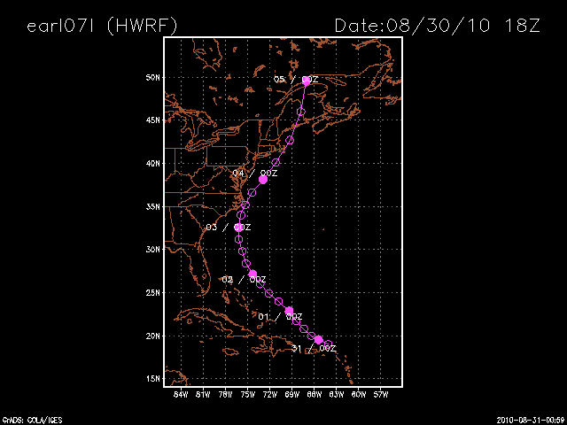
The hurricane models: gfdl keeps earl way off shore still, while the Hwrf tracks from 75/35 to the benchmark. I also like the look of their curve. They just don't brind earl close enough to obx to begin with. The NHC models have moved markedly west taking a similar path to the hwrf.
Intensity
Hwrf has earl as 80 kts (its been way underdone all along though) with the 50kt winds hitting obx. It keeps the winds at 80kts past the cape, but only ack sees 40-50 kts and the cape sees 30-40 kts. Still not a nice day. It deepens the storm from 952 to 948 as it goes east of the cape.
GFDL has it with 100-110kt winds off obx, with obx in the 60-70 kt range. By the time its over the bm, its down to barely 80kts, with 30 kt winds hitting ack and the cape. It keeps the pressure at 946 all the way up.
August 31 - interesting day in model worship. The GFS, Nogaps and Euro all brought Earl close to or over OBX and ACK. The wrf started that way and then shifted east on the 18z. Then went west, 20-30 miles closer to obx than on 18z run, but took it more ene out south of the bm.
All other models are still well, over 100 miles, out to sea. Local media having mixed reaction - some hyping, some saying its passing 300 miles west of obx (?). 12z GFS run was most impressive, but has backed off a bit at 18z. Feature to the right is the hwrf from yesterday
August 30
NHC has all of ct and half of nj in cone of uncertainty, with the main track just barely east of bm
18z hwrf hits obx and ack, nhc models way off coast, atcf cluster right off obx to just missing bm
18z gfs gets as far west as 75 off of sc/ga, then starts nne, about 100 mi off obx, but then heads more ne than before, going well east of bm and way east of ccod
12z gfs - about 70 miles off obx, then ne to just east of bm ,missing ack by about 70 mi and out to sea
12z eur0 - still takes it to about 70 miles off nc, then nne inside benchmark, over ack and just, barely, east of cc.
12zUKMET - takes it just n of bahamas, to 200 miles off nc/va and then hangs a 180 back out to sea.
12z cmc - same trend as ukmet - shifting east, but still within 100 mi of NC and just east of BM
0z Euro has Earl now 75 east of obx and passing within the BM, hitting ACK and CC.
0z CMC is same as Euro
6z GFS has it 120-130mi east of obx and nailing the BM
Above bring rain and wind into our area
0z UKMEt is farther east of NC, but drives more northerly into the bm and hits it square.
HRWRF takes it closer in to OBX like the euro, but curves it more ne just outside bm and missing us completely. It also barely maintains hurricane strength throughout.
GFDL keeps winds over 110kts, but it passes well east of the conus.
August 29 - NHC upgrades Earl to Hurricane with major status forecast. 5pm forecast has it moving maybe 150 miles east of NC and just to the east of the BM.
Euro - as west as 72/36 then to 68/40 on 9/3
GFS - same, with precip brushing RI/SMA
UKMET - looks like it tries to phase with Northern branch storm, comes very, very close to MD/DE up to ME (low resolution for details this far out on ewall site.
CMC - hits OBX, moves nne up over Montauk/ACK and CC
GFDL, HRWrf and ATCM models all have it recurving, coming in around 200 miles east of obx, except hrfwrf which now has it at 71/36
Intensity gfdl at 130kt+ at that time. hrwrf is at 70kt and only goes as high as 80kt.


.gif)

1 comment:
I still can't believe it hit the benchmark and all we got was sprinkles. Parts of LI and RI got 2 or so inches of rain.
Post a Comment