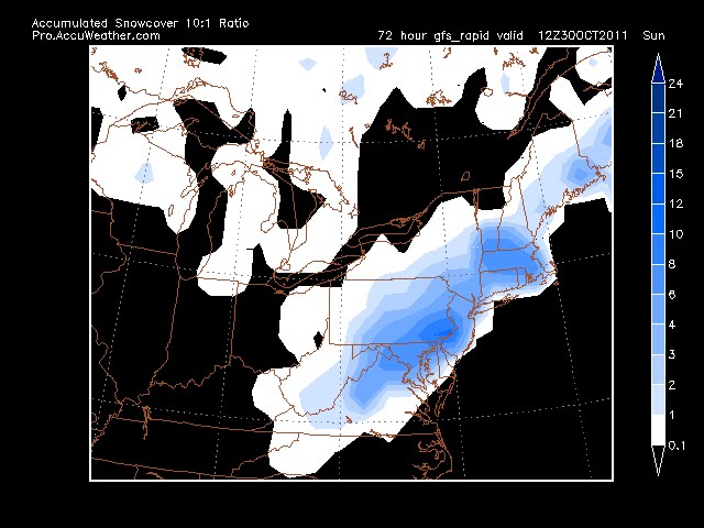
12z GFS pulls a bit in closer to land, has a 1004 low going to 996 of ACY in 6hrs. The -5isotherm is ok over the below target area and should support at least 10:1 snow ratio. The 0 850 isotherm remain just south of LI over Monmouth county and follows the tpke to PHL, until later when it crashes in. Areas north of this line will see a mix or all snow. South will be a rain to snow. The 0 line does not make it to the coast, so I will not see much snow in Ocean city. GFS bullseyse for snow is Springfield Ma, where it has 18 inches.
12z Nam is much more aggressive with the cold air aloft. The thickness line is well clear of dxr. the -5 isotherm is over entire ct and makes it to the coast, so according to it, there will be snow along the shore. Nam targets Sussex and Springfield MA with 12-18 inches. It also brings accumlulating snows to the shore.
12z Euro has 1.6 inches of precip for DXR. All falling with thicknesses that support mostly snow and all with the 850 temps between -4.6 and -5.7. Although it has ground temps in the 40's. Not buying the ground temps as if its going to snow or rain that hard and be that cold so close to the surface, the air temps will be in the low to mid 30's.
ukmet and cmc also agree with snow for the area.
Still think 3-5 for DXR. Will be tough to accurately measure since a lot will melt and compact. Not happy as leaves finally all turned, but are still on trees.
10-28
NWS has winter storm watch out for 4-8 inches of snow. Current models all have a significant snow event for this time of year. One NAM run and GFS run brings over 8" to CT. My earlier thoughts about boundary layer temps may be misguided. This morning we had a hard freeze, ground was crunchy. With temps in the 30's most of the day and falling into the 20's tonite, should allow for ground warmth to become less of a factor. I am expecting 6-8 inches in Sussex, Orange, Ulster, Dutchess, Litchfield and North of Hartford as its possible it never rains. 3-5 inches in Danbury, Northern Westchester, Putnam, Rockland. 1-3 around the Essex, White Plains and Bergen counties. I'm undercutting all mets at this point since in areas south of 84, this is unprecedented in my lifetime. It is believable for Sussex and Litchfield ctys, perfect storm hit them. So climatology is keeping me from making a call that its a big storm for everyone. the 0z Euro is nuts bringing heavy snows into the city and almost to the coast- see below. The entire state of Ct is below -5 at 850 at this time. Snow ratios should be 10:1 if thats the case.

10-27 12 GFS comes around to Euro idea, Euro maintains coastal track, see GFS snow map below.
 UKMET agrees, CMC is farthest east. NAM misses the area completely, but brushes SNJ and RI
10-26 Euro pushed east a bit, then came back west. JMA still supports large storm, euro not as bad, but still snow on Sat. GFS has snow on Sat as well, but mostly to our south. 18z nam way out to sea with no precip.
10-25 update - Euro hanging on, but losing support
Mets and models catching onto possible snow in the area thurs nite. Still a coating or no accum is likely.
Saturday is another problem. Euro continues to blow up a storm and have it snow. 0z ukmet supports it, 0z cmc brushes east ct and south nj with snow, but more out to sea (ots). DGEX and 0,6 and 12z GFS don't phase the storms and are suffering from interference from Rina. Thus keeping one storm out to sea and the other goes north, or not even showing a shortwave. 12z cmc is way out to sea, and can't tell on the ukmet, but also looks ots.
JMA is still bullish like Euro
10-24 afternoon update.
JMA puts a 990 low off the cape on sunday, with 850 temps supporting snow (no word on ground temps though).
ukmet has nice low to our south and high right where it needs to be on the 0z run, but the 12z bombs one up the coast (no guidance as to temps yet but the 540 height is there indicating cold enough aloft).
12z cmc brings the 0/850 line over us thurs morn and keeps it to the south as waves move over on thurs and fri, but keeps the precip south as well. Funny if SNJ got snow before us. On sat it blows up another wave into a good low, but right over PHL, resulting in rain to snow for DXR.
12zeuro brings the 850 line south of us on fri, with some residual flurries. But really winds up the storm off the coast on Sat, with serious snow, based on the 850 temps. By Sat, the ground may be closer to 35 or 38 degrees if it gets that cold on thurs. The low on Sun morn is off CCod around 986mb
So all models but CMC have a good storm brewing, CMC is just too inland.
NWS is not on this right now. Will see if they mention later though.

10-24
I had been thinking mid november for the first 1" snow on the ground, with the first flakes in the beginning of Nov.
This mornings gfs has a shocking prediction of snow on the ground for the 28th! First run I've seen with over 1" The 0z Euro kinda supports it too, either the 27th or 30th. However, we haven't even had a frost yet, so it will really have to snow hard as to not melt as the ground temps are probably closer to 50. So I will say that it will not accumulate over an inch due to ground warmth, but if it were two weeks later, it would have had a better chance.


.gif)

No comments:
Post a Comment