12-2 Flurries out today, high of 37
12-1. It's 55 out at 10am. Cold front is late coming through. The Nam is not showing much in the way of precip either after the cold front or ahead of the warm front. Anything will be light. Euro is a little more robust with some snow tues evening. Gfs has a little brief light snow. My fear with the lack of amounts is that the precip is used up in evaporational process and falls as virga.
Fri nite snow also is minimal, if any. Gfs has wave staying to our south. Euro has little front end snow, then bulk of moisture after it has warmed.
11-29 - Nothing major in the next week. But there are two events, Tues nite and Fri nite, which may produce some wintry precip. Looks like a warm front comes through Sunday (surprisingly no precip) and cold front comes in Monday nite. As it cools off Tuesday, a warm front should produce some overrunning precip Tuesday night. Could be snow to rain or snow to freezing rain to rain. Coating to an inch at this time. Warms up Wednesday, then a cold front hangs to our south on Thursday. A wave forms on the front and again creates a warm air overrunning event for Friday. This one looks a little more potent, but again a snow to rain event. Euro has high pressure in place for both though and there is some evidence of cold air damming. GFS has the high too, but moves it out. Much drier look as well.
Saturday, November 29, 2014
Friday, November 21, 2014
Thanksgiving(eve)
11-27 - Results - 4". Started as rain, mixed at 9am (as planned), snowed until around 3:30, mixed with sleet, then all sleet from 4-8, rained 8-9 and turned back to snow. Warming occurred at 700mb level, where we were right on that edge. Euro wins this one, but didnt really nail it. LP passed over ACK per RAP. GFS caught on last to the inside BM track, the parallel was miserable, as was the CMC and JMA. UKIE had this inside the BM too, but also had a run with the lp over NYC. Flurries out Thanksgiving morning as I type.

0z gfs run maps. Seems to be further west and warmer. 850 line really close, but checked rest of the layers and they are good for mostly snow.

11-25 - latest NAM map from weatherbell since Accuweather's is messed up

evening summary. I thought the mix was done, but some hints at warming again at 700mb. Below are the 12z maps for Euro, GFS and NAM. Euro and NAM have no 700mb issues, but the Euro has cut down accums and the NAM snowfall maps on accupro are messed up. Still thinking 8-10" in Northern Fairfield, but hedging toward 8 based on maps below.
THU 00Z 27-NOV 1.1 -1.4 130 1566 36013 SN 0.83 0.59
THU 06Z 27-NOV -1.1 -3.1 129 301 34007 SN 0.91 0.65
THU 12Z 27-NOV -1.5 -5.0 129 168 34004 SN 0.91 0.65
THU 18Z 27-NOV 0.7 -6.1 129 709 32004 SN 0.96 0.65
FRI 00Z 28-NOV -2.3 -7.0 129 249 31005 SN 0.97 0.65
WED 7P 26-NOV 0.5 -2.8 1010 93 96 0.77 553 545
THU 1A 27-NOV 0.1 -3.7 1012 89 92 0.24 541 532
THU 7A 27-NOV -0.9 -5.1 1016 87 80 0.01 541 528


morning summary - Euro and GFS both agree on mix to start 12z, light. Snow thereon for DXR. NAM and ECMWF are slightly inside the BM, GFS right over. NAM at 996, Euro at 1000 and GFS at 1002. Only big difference now is precip amt. GFS is driest at .72, Euro has 1.12 and NAM is 1.51. SREF plume for Oxford is 10-11" Temperatures are all similar, and support a mostly snow event for Northern Fairfield County, Putnam, Orange, N Westchester and even NNJ. NWS has 8-10 now on their map, with 4-8 in their WSW and 6-12 in their text.
Out rest of day at client.
11-24 Evening. 0z Nam printout. 1.4" qpf, mostly when under 0 zt 850/925 (925 cut off is S NJ). 700mb temps below 0 except for immediate NJ coast, New London cty , RI and SE Ma. Even so, highest accumulations on the NAM are 8".

0z GFS printout
18z GFS printout
12z RGEM hits the BM, but has mix for I84, rain south. CMC though has the 850 line clearly over open water. JMA finally showed up on today's 12z run, but is still far east (no pun intended). NAVGEM has precip, but not alot, no LP forms. SREF is over BM, with 21z plume mean at 12", which is up from 9" on the 15z run
Thinking models are having issues with the current surface temps (60's) and cooling them down rapidly. There is support for heavy precip with frontogenesis and vertical velocities, which should get the temps down to 32-34 at the surface which supports accumulation.
11-24 12z Euro update
Its evolution - showing at 6z Thurs
Meanwhile, precip still copious

And 850 temps below for much of the NE except the coast. 700 temps also are below 0 except for SE CT/RI/SE Mass for the 0z Thurs frame. Vertical Velocities and Frontogenis are high at the 700mb level as well, implying heavy snow during that time. So Euro still calling for 10" in NW NJ, 8-10 in northern half of NJ, 10-12" most of CT with higher amts NE

------------------------------------------------------------------------------------------
11-24 early afternoon. GFS tweaked a little to the right, but still keeps the precip in the .9-1 range. Most precip falling as snow, but not accum right away. Some printouts below. UKMET came in with a low over NYC?! NAM HiRes is in and its got cold 850's and a lot of precip with surf temps near 0. 9z SREF over BM with 850s only a problem south of NJ and at the coast, and 700 temps warm for SE Mass and RI. RGEM 12z has the R/I/S line right on us.

GFS printouts 12z
12Z NOV24 * - APPROXIMATED
2 M 850 1000 FZING SFC SFC 6 HR SNCVR
TMP TMP 850 HGT WIND PCP QPF LIQ
(C) (C) THK (FT) (KTS) TYPES (IN) (IN)
WED 12Z 26-NOV 2.9 1.1 130 5212 03008 SN 0.00 0.00
WED 18Z 26-NOV 0.8 -3.0 129 801 01010 SN 0.55 0.40
THU 00Z 27-NOV 0.7 -3.7 129 801 35012 SN 0.31 0.63
THU 06Z 27-NOV 0.1 -4.7 129 500 32008 SN 0.07 0.69
THU 12Z 27-NOV -0.7 -6.4 129 278 30005 SN 0.01 0.69
THU 18Z 27-NOV 0.5 -7.1 128 634 31008 SN 0.00 0.69
PRESS LEVEL SFC 1000 925 850 700 600 500 400 300 200
WED 12Z 26-NOV 4 3 -1 1 -9 -8 -12 -22 -36 -60
WED 18Z 26-NOV 3 1 -2 -3 -8 -6 -12 -22 -34 -58
THU 00Z 27-NOV 2 1 -2 -4 -8 -11 -20 -24 -34 -54
THU 06Z 27-NOV 2 0 -2 -5 -12 -19 -25 -33 -39 -50
THU 12Z 27-NOV 1 0 -3 -6 -14 -22 -30 -40 -43 -47
THU 18Z 27-NOV 3 0 -4 -7 -15 -23 -32 -43 -45 -47
11-24 morning - Winter Storm Watch in effect for 4-8 inches. GFS runs cold and with over .9" qpf. Euro has mostly snow, with a mix at 0z thurs with total qpf of 1.26. GFS all snow, accumulations iffy as surface is above freezing for some of it, but it should come down hard enough for 5:1 ratios then 10:1 ratios as colder air enters the column. NAM is still east of the benchmark, but has all the temps at or below freezing for DXR through the event. Nam precip in CT goes from .5-.75 to 1-1.25" west to east, but the snow maps only showing 3-6 inches.
Euro moves east 100 miles. LP now passing east of LI, still within the Benchmark

Euro printout looks like its mostly snow, though surface temps are a little warm. I don't always believe the surface temps on the Euro as whenever there is a heavier precip event, the temps usually get to 32-33 and it accumulates. Total qpf 1.26. Looking at temps in the 850-500mb layers, there is one time at 0z that the 700mb temps are over 0. So there could be a good amount of sleet during that time period.
2 M 850 1000 FZING SFC SFC 6 HR SNCVR
TMP TMP 850 HGT WIND PCP QPF LIQ
(C) (C) THK (FT) (KTS) TYPES
WED 12Z 26-NOV 3.7 -1.2 130 1702 0300 0.02
WED 18Z 26-NOV 1.7 -2.6 130 713 04010 0.34
THU 00Z 27-NOV 1.2 -2.7 129 11049 0201 0.48
THU 06Z 27-NOV 0.4 -6.4 128 404 34013 0.32
THU 12Z 27-NOV -1.9 -5.3 128 197 30009 0.10
(IN) (IN)
GFS 0z shows nice storm at 72 hrs. Its printout is colder at the surface and at 850mb. Total qpf for dxr of .96. Snow map with 8-10 inches.

 Then 6z snow map is a bit less further south, but still solid 6+ for most of CT. .93 qpf on the printout with 850's of -2 to -6 through the event. 700 and 500mb temps are also all snow.

NAM runs show a little NW push with the precip, less impressive on the location of the LP. Seems like the earlier hours have the greater shift, and later in the run the are more similar. Its QPF for DXR on the printout is over .7, but only shows in the 3-6 range. Temps are very cooperative.
----------------------------------------------------------------------------------------------------------------------
11-23 evening
12z GFS Off SC at 7am with 1012 mb, to east of OBX, hits BM late Wed nite, and off Cape Cod as 992 mb low by 1am. Drops from 1012 to 984 in 24 hrs. 18z run is slightly more west and noticeably weaker. 12z offers 6-6" on the snow map, 18z offers 8-10"
12z Euro starts off SC at 7am with 1008 low, looks like it goes inside OBX, off Delmarva as 1000mb low at 7pm, crosses ISP as 992 low at 1am. 988 low off Portsmouth at 7am. So only 20mb drop for the Euro. Euro still puts out 12-18 inches though, which based on the track does not seem right as the 850s are too warm. Meanwhile the Euro ens control is a benchmark storm with 10-12" legit. Euro ens mean is in between.
12z CMC still way offshore, brushing the coast with snow, RGEM has rain south of NYC with some snow N of NYC, but little. 12z JMA still way offshore. GFS.25 parallel is way offshore. NAM way off shore, but brushes us.
NWS has an interesting approach - their forecast
11-23 morning
0z gfs forms 1012 low off SC 12z Wed, light precip enters NY metro 15z, 1008 lp goes off OBX 125 miles east or so by 18z and snow is falling moderately. 0z Thurs storm center is just south of BM east of NJ, 6z and still 1008 225 miles east of Cape Cod, snow is tapering off in NY metro. QPF below - most is snow as surface temps inland are under 0c and very close until the immediate coast. 3-6 inches generally in the areas shown getting qpf below.
 6z gfs runs low about 50 miles off OBX, really close to the BM and deepening more than the 0z run. So much closer to shore and down to 992 as it passes the Cape. Timing similar. Way different qpf map. However, there are temp issues with the 850 and 925 line just offshore (except RI, SE MA and Cape). Result is a widespread 6-9" storm for most areas away from the coast.


Euro meanwhile shifts further west, with the low going inside OBX, right off ACY and 992 over eastern LI and 984 into Gulf of ME. 850 line backs for some of the storm to about Rt 8 in CT and Cross ISL Pky in NY. Brings rain to most of CT, MA and all of RI for some of the heaviest parts of the storm. Also interesting is that the 700mb 0 degree line is actually further north/west than the 850 and 925 lines, indicating sleet. Surface temps are above freezing for most of the area, but the Euro snow map still lays down 12-16"
 Other models: UKMET as close if not closer to coast than Euro. My guess on that is a snow/rain/snow event for most inland areas. CMC looks like a lone wolf - no precip as low is too far offshore. DGEX comes to CMC's rescue also with a completely offshore event. NAVGEM in between with it brushing the coast, moreso in SNE. GFS ens and parallel are east of the det. GFS. Euros ensembles support the det. though are slightly east. Not talking about the NAM yet.
11-22 evening
18z DGEX brushes CT East and Jersey shore
18z GFS moves further west. GFS.25 is not buying it yet. The parallel gfs keeps the GL low strong and separate from the coastal. It does bring some snow to the Cape.
12z Euro seems to have moved a bit further west, but same result as 0z. Ensembles are a bit east, but close enough to support the idea of a storm.
11-22
0z Euro and UKMEt showing a solid storm for the EC. 850 and 925 temps are cold. Surface temps still marginal, but with values seen on the 700mb Vert velocity, there should be heavy enough snow to convert the surface to at or below freezing.
CMC and JMA still not showing anything close to the coast. NAVGEM is between 12z GFS and Euro, brushing us.
0z GFS brushes us with some snow, but is further off the coast. 6z is offshore and is less enthusiastic about forming a low. Same with 12z. GFS ensembles showing some love for the Euro. GFS .25 a little stronger of a low, but still offshore.
So, in summary Euro/UKMET (strong storm) vs. GFS/CMC/JMA (offshore) with DGEX/NAVGEM in between.
11-21 evening . 18z GFS is close to this mornings Euro solution. Hmmm..
18z DGEX still has nothin, JMA has a little snow along the coast at hr 144.


11-21 Models all over the place, most have had a front come through Wednesday. Once in a while a wave would be seen either coming through the Lakes or off the coast. Todays Euro is interesting though. Morning run had snow Wed into Thurs. Waiting for 12z graphics, but that run has a cut off upper low, stacked over a 995 surface low on Thurs nite/Fri Morn with it bombing to 980 offshore. GFS .25 also has storm, but OP GFS does not. Still too early to look at ensembles. GGEM is offshore, GFS offshore, DGEX offshore.
12z run has a weaker storm Wed into Thurs, more offshore. Focus on that run has an upper low meet a surface low off OBX, which then meanders a while in that area before heading ENE to a 40/65 position E of the benchmark as a 970 low.
0z pics


0z gfs run maps. Seems to be further west and warmer. 850 line really close, but checked rest of the layers and they are good for mostly snow.
 | |
| not all this sticks |
11-25 - latest NAM map from weatherbell since Accuweather's is messed up
evening summary. I thought the mix was done, but some hints at warming again at 700mb. Below are the 12z maps for Euro, GFS and NAM. Euro and NAM have no 700mb issues, but the Euro has cut down accums and the NAM snowfall maps on accupro are messed up. Still thinking 8-10" in Northern Fairfield, but hedging toward 8 based on maps below.
|
| Euro just inside BM, no 850 issue |
|
| Euro qpf 1.13 by thurs morn in dxr |
|
| Euro snow, a bit less than prior runs |
GFS at 12z has a solid storm - printout showing all snow.
WED 12Z 26-NOV 2.9 -1.8 130 3204 03011 SN 0.06 0.03
WED 18Z 26-NOV 1.3 -2.1 130 1973 02012 SN 0.51 0.36 THU 00Z 27-NOV 1.1 -1.4 130 1566 36013 SN 0.83 0.59
THU 06Z 27-NOV -1.1 -3.1 129 301 34007 SN 0.91 0.65
THU 12Z 27-NOV -1.5 -5.0 129 168 34004 SN 0.91 0.65
THU 18Z 27-NOV 0.7 -6.1 129 709 32004 SN 0.96 0.65
FRI 00Z 28-NOV -2.3 -7.0 129 249 31005 SN 0.97 0.65
| GFS right over BM at 36 |
| GFS precip .96 for DXR |
| GFS snow on ground 8-10 |
NAM is having issues reconciling snow amounts and precip. As you can see on the meteogram from 18z, there is no layer after 15z above freezing, yet the snow chart is showing 3" for 1.4" qpf. that's a 1:5 ratio??
NAM printout - 18z
WED 7A 26-NOV 3.5 -0.8 1022 76 97 0.00 565 547
WED 1P 26-NOV 0.6 -3.1 1018 96 96 0.38 561 547 WED 7P 26-NOV 0.5 -2.8 1010 93 96 0.77 553 545
THU 1A 27-NOV 0.1 -3.7 1012 89 92 0.24 541 532
THU 7A 27-NOV -0.9 -5.1 1016 87 80 0.01 541 528
| NAM 12z inside BM |
| snow, doesn't match upper air or precip, or other sites versions |
| 1.4" qpf for DXR - a little overdone? |
| 18z ups the precip. but |
| backs the snow down and west. |
But then there is this map from instant weather.
And weatherbell
-----------------------------------------------------------------------------------------------------------------
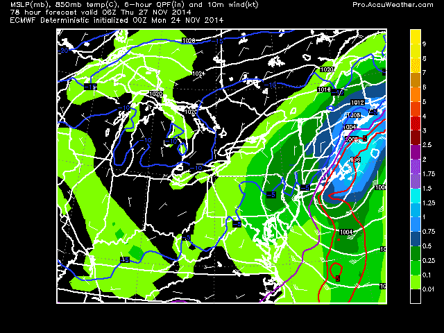
morning summary - Euro and GFS both agree on mix to start 12z, light. Snow thereon for DXR. NAM and ECMWF are slightly inside the BM, GFS right over. NAM at 996, Euro at 1000 and GFS at 1002. Only big difference now is precip amt. GFS is driest at .72, Euro has 1.12 and NAM is 1.51. SREF plume for Oxford is 10-11" Temperatures are all similar, and support a mostly snow event for Northern Fairfield County, Putnam, Orange, N Westchester and even NNJ. NWS has 8-10 now on their map, with 4-8 in their WSW and 6-12 in their text.
Out rest of day at client.
11-24 Evening. 0z Nam printout. 1.4" qpf, mostly when under 0 zt 850/925 (925 cut off is S NJ). 700mb temps below 0 except for immediate NJ coast, New London cty , RI and SE Ma. Even so, highest accumulations on the NAM are 8".
WED  1A 26-NOV   6.7     1.4    1021      64      36    0.00     564     547
WED  7A 26-NOV   3.1    -3.1    1023      79      97    0.03     563     544
WED  1P 26-NOV  -0.1    -3.5    1017      97      95    0.70     559     545
WED  7P 26-NOV  -0.2    -4.1    1012      92      97    0.61     549     539
THU  1A 27-NOV  -0.7    -4.1    1014      88      94    0.06     541     530
0z GFS printout
WED 12Z 26-NOV   3.1     2.0    1021      74      96    0.01     563     546
WED 18Z 26-NOV   1.1    -2.3    1017      96      98    0.40     558     544
THU 00Z 27-NOV   0.8    -3.4    1014      95      99    0.27     551     540
THU 06Z 27-NOV  -0.8    -3.1    1015      94      79    0.03     547     535
18z GFS printout
WED 12Z 26-NOV   2.7    -0.3    1022      78      92    0.02     563     546
WED 18Z 26-NOV   0.9    -2.7    1017      97      99    0.47     558     545
THU 00Z 27-NOV   0.8    -3.8    1013      95      99    0.26     550     540
THU 06Z 27-NOV   0.1    -4.6    1016      93      99    0.05     544     531
So the late runs of the GFS show .7 to .8 qpf with marginal start temps. Still supports warning criteria snow fall of 6+". 18z GFS Ens have a BM hit with spread to the west
| 18z gfs snow |
12z RGEM hits the BM, but has mix for I84, rain south. CMC though has the 850 line clearly over open water. JMA finally showed up on today's 12z run, but is still far east (no pun intended). NAVGEM has precip, but not alot, no LP forms. SREF is over BM, with 21z plume mean at 12", which is up from 9" on the 15z run
Thinking models are having issues with the current surface temps (60's) and cooling them down rapidly. There is support for heavy precip with frontogenesis and vertical velocities, which should get the temps down to 32-34 at the surface which supports accumulation.
11-24 12z Euro update
Its evolution - showing at 6z Thurs
 | |
| 12z 11-23 run |
 |
| 0z 11-24 run |
 |
| 12z 11-24 run |
| warmest 850 from 12z run |
------------------------------------------------------------------------------------------
11-24 early afternoon. GFS tweaked a little to the right, but still keeps the precip in the .9-1 range. Most precip falling as snow, but not accum right away. Some printouts below. UKMET came in with a low over NYC?! NAM HiRes is in and its got cold 850's and a lot of precip with surf temps near 0. 9z SREF over BM with 850s only a problem south of NJ and at the coast, and 700 temps warm for SE Mass and RI. RGEM 12z has the R/I/S line right on us.
 |
| ukmet 12z mslp 850 |
GFS printouts 12z
12Z NOV24 * - APPROXIMATED
2 M 850 1000 FZING SFC SFC 6 HR SNCVR
TMP TMP 850 HGT WIND PCP QPF LIQ
(C) (C) THK (FT) (KTS) TYPES (IN) (IN)
WED 12Z 26-NOV 2.9 1.1 130 5212 03008 SN 0.00 0.00
WED 18Z 26-NOV 0.8 -3.0 129 801 01010 SN 0.55 0.40
THU 00Z 27-NOV 0.7 -3.7 129 801 35012 SN 0.31 0.63
THU 06Z 27-NOV 0.1 -4.7 129 500 32008 SN 0.07 0.69
THU 12Z 27-NOV -0.7 -6.4 129 278 30005 SN 0.01 0.69
THU 18Z 27-NOV 0.5 -7.1 128 634 31008 SN 0.00 0.69
PRESS LEVEL SFC 1000 925 850 700 600 500 400 300 200
WED 12Z 26-NOV 4 3 -1 1 -9 -8 -12 -22 -36 -60
WED 18Z 26-NOV 3 1 -2 -3 -8 -6 -12 -22 -34 -58
THU 00Z 27-NOV 2 1 -2 -4 -8 -11 -20 -24 -34 -54
THU 06Z 27-NOV 2 0 -2 -5 -12 -19 -25 -33 -39 -50
THU 12Z 27-NOV 1 0 -3 -6 -14 -22 -30 -40 -43 -47
THU 18Z 27-NOV 3 0 -4 -7 -15 -23 -32 -43 -45 -47
11-24 morning - Winter Storm Watch in effect for 4-8 inches. GFS runs cold and with over .9" qpf. Euro has mostly snow, with a mix at 0z thurs with total qpf of 1.26. GFS all snow, accumulations iffy as surface is above freezing for some of it, but it should come down hard enough for 5:1 ratios then 10:1 ratios as colder air enters the column. NAM is still east of the benchmark, but has all the temps at or below freezing for DXR through the event. Nam precip in CT goes from .5-.75 to 1-1.25" west to east, but the snow maps only showing 3-6 inches.
Euro moves east 100 miles. LP now passing east of LI, still within the Benchmark
Euro printout looks like its mostly snow, though surface temps are a little warm. I don't always believe the surface temps on the Euro as whenever there is a heavier precip event, the temps usually get to 32-33 and it accumulates. Total qpf 1.26. Looking at temps in the 850-500mb layers, there is one time at 0z that the 700mb temps are over 0. So there could be a good amount of sleet during that time period.
2 M 850 1000 FZING SFC SFC 6 HR SNCVR
TMP TMP 850 HGT WIND PCP QPF LIQ
(C) (C) THK (FT) (KTS) TYPES
WED 12Z 26-NOV 3.7 -1.2 130 1702 0300 0.02
WED 18Z 26-NOV 1.7 -2.6 130 713 04010 0.34
THU 00Z 27-NOV 1.2 -2.7 129 11049 0201 0.48
THU 06Z 27-NOV 0.4 -6.4 128 404 34013 0.32
THU 12Z 27-NOV -1.9 -5.3 128 197 30009 0.10
(IN) (IN)
GFS 0z shows nice storm at 72 hrs. Its printout is colder at the surface and at 850mb. Total qpf for dxr of .96. Snow map with 8-10 inches.
----------------------------------------------------------------------------------------------------------------------
11-23 evening
 |
| 18z GFS at 06z Thurs |
12z Euro starts off SC at 7am with 1008 low, looks like it goes inside OBX, off Delmarva as 1000mb low at 7pm, crosses ISP as 992 low at 1am. 988 low off Portsmouth at 7am. So only 20mb drop for the Euro. Euro still puts out 12-18 inches though, which based on the track does not seem right as the 850s are too warm. Meanwhile the Euro ens control is a benchmark storm with 10-12" legit. Euro ens mean is in between.
| |
| Euro at 6z Thurs. Center over LI -warm 850s |
12z CMC still way offshore, brushing the coast with snow, RGEM has rain south of NYC with some snow N of NYC, but little. 12z JMA still way offshore. GFS.25 parallel is way offshore. NAM way off shore, but brushes us.
NWS has an interesting approach - their forecast
- Wednesday Snow likely, mainly after noon. Cloudy, with a steady temperature around 34. Chance of precipitation is 60%.
- Wednesday Night Snow likely. Cloudy, with a low around 29. Chance of precipitation is 60%.
DAYS TWO THROUGH SEVEN...MONDAY THROUGH SATURDAY.

A COASTAL STORM IS EXPECTED TO AFFECT THE REGION WEDNESDAY INTO
WEDNESDAY NIGHT...BUT UNCERTAINTY STILL EXISTS IN HOW CLOSE TO THE
REGION THIS STORM WILL TRACK. A COMBINATION OF SNOW...RAIN...AND
WIND ARE LIKELY WITH THIS SYSTEM.

ALTHOUGH IT IS TOO EARLY TO DETERMINE EXACT SNOW AND RAIN
AMOUNTS...THERE IS A LOW PROBABILITY OF 6 OR MORE INCHES OF SNOW
ACROSS AREAS TO THE NORTH AND WEST OF THE NYC METRO AREA BY THE
TIME THE STORM WINDS DOWN LATE WEDNESDAY NIGHT. CONTINUE TO
MONITOR NWS FORECASTS FOR THE LATEST ON POTENTIAL STORM RELATED
HAZARDS AND IMPACTS DURING THE BUSY MIDWEEK HOLIDAY TRAVEL PERIOD.
11-23 morning
0z gfs forms 1012 low off SC 12z Wed, light precip enters NY metro 15z, 1008 lp goes off OBX 125 miles east or so by 18z and snow is falling moderately. 0z Thurs storm center is just south of BM east of NJ, 6z and still 1008 225 miles east of Cape Cod, snow is tapering off in NY metro. QPF below - most is snow as surface temps inland are under 0c and very close until the immediate coast. 3-6 inches generally in the areas shown getting qpf below.
Euro meanwhile shifts further west, with the low going inside OBX, right off ACY and 992 over eastern LI and 984 into Gulf of ME. 850 line backs for some of the storm to about Rt 8 in CT and Cross ISL Pky in NY. Brings rain to most of CT, MA and all of RI for some of the heaviest parts of the storm. Also interesting is that the 700mb 0 degree line is actually further north/west than the 850 and 925 lines, indicating sleet. Surface temps are above freezing for most of the area, but the Euro snow map still lays down 12-16"
11-22 evening
18z DGEX brushes CT East and Jersey shore
18z GFS moves further west. GFS.25 is not buying it yet. The parallel gfs keeps the GL low strong and separate from the coastal. It does bring some snow to the Cape.
 |
| 18z GFS mslp 850 |
 |
| 18z gfs snow |
12z Euro seems to have moved a bit further west, but same result as 0z. Ensembles are a bit east, but close enough to support the idea of a storm.
11-22
0z Euro and UKMEt showing a solid storm for the EC. 850 and 925 temps are cold. Surface temps still marginal, but with values seen on the 700mb Vert velocity, there should be heavy enough snow to convert the surface to at or below freezing.
 | |
| Vertical Velocity showing heavy snow |
 |
| Snow accumulation on Thanksgiving |
 |
| mslp and 850 Wed evening |
 |
| UKMET at hr 120 |
CMC and JMA still not showing anything close to the coast. NAVGEM is between 12z GFS and Euro, brushing us.
0z GFS brushes us with some snow, but is further off the coast. 6z is offshore and is less enthusiastic about forming a low. Same with 12z. GFS ensembles showing some love for the Euro. GFS .25 a little stronger of a low, but still offshore.
So, in summary Euro/UKMET (strong storm) vs. GFS/CMC/JMA (offshore) with DGEX/NAVGEM in between.
11-21 evening . 18z GFS is close to this mornings Euro solution. Hmmm..
18z DGEX still has nothin, JMA has a little snow along the coast at hr 144.
11-21 Models all over the place, most have had a front come through Wednesday. Once in a while a wave would be seen either coming through the Lakes or off the coast. Todays Euro is interesting though. Morning run had snow Wed into Thurs. Waiting for 12z graphics, but that run has a cut off upper low, stacked over a 995 surface low on Thurs nite/Fri Morn with it bombing to 980 offshore. GFS .25 also has storm, but OP GFS does not. Still too early to look at ensembles. GGEM is offshore, GFS offshore, DGEX offshore.
12z run has a weaker storm Wed into Thurs, more offshore. Focus on that run has an upper low meet a surface low off OBX, which then meanders a while in that area before heading ENE to a 40/65 position E of the benchmark as a 970 low.
0z pics
12z Pics
12z pics

-
 11/27 update - happy thanksgiving. GFS has gone from major noreaster, to huge cutter to lakes and now has a minor clipper system sinking do...
 -
 2/22 - results 5.25 inches. Snow started at 2, lasted 12 hrs with varying intensity and types of snow. Kudos for the models, weather serv...
 -
.gif) 2/9 Set up is an upper low over TX that heads northeast into TN valley and then transfers off the coast. At the upper levels, there's ...
2/9 Set up is an upper low over TX that heads northeast into TN valley and then transfers off the coast. At the upper levels, there's ...