11/20 ...a little warmer in the beginning, less snow with colder more normal temps in Feb/Mar and more snow. Not expecting many 6+ storms, but we could get half the seasonal snow with one hit in Feb/Mar. Overall I'm thinking +.2 to .5 for temps and within 5" of normal for snow.
Based on looking at various outlooks by various weather agencies and other forecasters, my prediction is for a winter which will not be nearly as cold as the last few, closer to normal temps and slightly less than normal snow with a few ice storms. Aside from reading a dozen or so other forecasts, you can't ignore the El Nino, which is by many accounts the second strongest since 1950, and even stronger in some regions than 1997.
 |
| Another look at 3.4 |
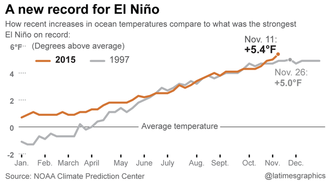 |
| From LA Times, Region 3.4 |
1997/98 was a very warm and snowless winter (5" in Central Park). There are mets out there who will point out this is not a 1997 El Nino (the strongest), but you can't discount it as a whole. Approx 3/4 of the "mets" I follow are calling for a warm start, cold end. The other 1/4 are calling for persistent warmth. Why I buy the majority argument is that El Nino is forecast to crash pretty hard in the spring. As the Pacific shifts towards neutral, the jet should change and shift back to a more normal look. The key is how fast El Nino tops off (is it now?) and how fast it declines.
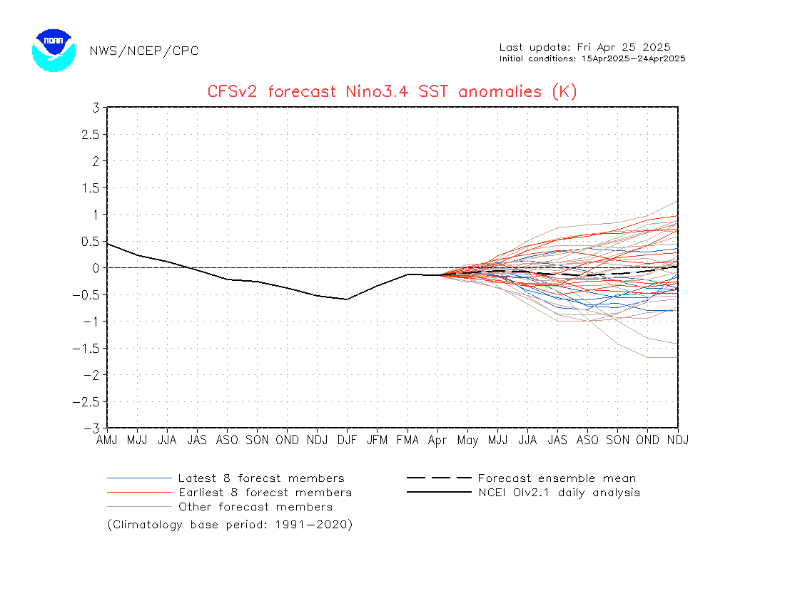 |
| Predicted fall to neutral by summer | |
|
|
|
It could delay or peak a month late, which messes up just about everyones outlook. Both Atlantic and Pacific temps are warmer than normal, with the Atlantic looking like its transitioning out of a +AMO. Warmer ocean temps lead to more moisture, so when winter pokes back at us, we are looking at a stronger subtropical jet and warmer Atlantic (for now) which would lead to stronger storms, heavier precip. Hence the call for some potent storms later in the year. The track of these storms would have to be worked out later though and its more likely than not they head to our west, resulting in either ice storms or front end snow, rain events. Current storms are tracking to the lakes, which I expect to continue through December, but after that can't tell.
 |
| Atlantic Temps = more moisture available |
 |
| Pacific Temps = stronger storms in ST Jet |
I'm also researching warm ocean temps and falling or rising heights and pressures as a result. I would expect that as the difference in land v. sea temps expands, the affects of a warmer ocean increase. If you're at the shore, particularly in the spring, you'll notice as the land warms, the rising air draws in the cooler ocean air creating a sea breeze. The warmth draws in cold to replace it. At night, the warmer ocean then draws in the air from the land, but its usually not as strong as the temp difference is less. So does having near coastal water +2 to +3 warmer than normal cause air to be drawn to it from the cooler land. Just a thought.
Should throw in as a final point, that the latest (11/20) CFSv2 run for
850 temp anomalies as warmer in Jan, colder in Feb and Mar. Not sure
how I feel about that.
 |
| Feb 850 temp anomalies |
 |
| March 850 temp anomalies |


.gif)
