result 3.5" of snow, gone by end of day
3-19
Evening
Nam still inching back
And GFS is on board with snow!
RGEM goes just outside benchmark
GEFS has a pretty far east track still, but is more abundant with moisture.
Afternoon. GFS/NAM/Euro/CMC Models inching westward, putting flakes back in forecast, GGEM with bigger storm, warning criteria
Euro coming a bit west.
 |
| 12z |
 |
| 0z |
GFS coming west
 |
| 12z |
 |
| 0z |
NAM coming west
 |
| 12z |
 |
| 0z |
 |
| 0z |
 |
| 12z |
3-18 Evening. NAM/GFS with misses. Euro brushing us. UKMET still on board. CMC very strange solution - goes to two lows, first out to sea, W to E, then the second comes up from F, weak, and takes sharp right off DE/MD and heads ENE but does bring a good snow. JMA still has it
Euro ens still goes over BM. GFS ens aren't that far off either. Still enough to watch.
morning. Euro caved to GFS, grazes us with a few inches. GFS 0z run nearly a complete miss. UKIE, JMA still on board. But even a greater difference between the euro 12z and 0z run is the Nam 0z to 6z run. Wild. We can't figure out the cause. NAM and Euro just sped up the surface low to the GFS timing. GFS timing is usually too fast, so this is odd. I suppose its right for the first time this year?
 |
| NAM 0z |
 |
| NAM 6z |
 |
| NAM 6z |
 |
| NAm 0z |
?????????????????????????????????????????????
3-17 afternoon -GFS coming west, again like yesterday, but still doesn't put it all together. Its faster and likely jumping energy out ahead. CMC is west again. UK still scores us, still beyond 72 hrs so no details, but path is favorable for major storm.
3-17 Ingredients there for major storm - its how the pieces come together.
Euro is impressive this morning. LP goes by us at 980mb with plenty of cold air at 700/850/925mb levels. It starts off OBX at 1000mb at 0z, 992mb due south of Newtown, off Cape May at 6z, to 980mb just south of Marthas Vineyard at 12z (Bombing) to 972mb approaching Portland. Tropical force sustained winds briefly along NJ coast, more extensive over Cape Cod, with gusts to hurricane strength. Inland winds are less, as usual, but get gusty as the storm passes with some gusts in the 40kt range. Ensemble supports.
UKMET has it, perhaps a bit further west. JMA has it a little east.NAVGEM is a little east - both develop it later than UK and EC.
GFS is almost completely out to sea again, despite its pulling it back into our area, alarming me, yesterday. Its much weaker, no phasing. Should note the ensemble is further west, a red flag.
 |
| 0z gfs |
 |
| 6z gfs |
|
CMC has reversed itself from the 966 low off Cape Cod on the 12z run yesterday to a 996 low going out to sea tomorrow.
???????????????????????????????????????????????????????????????????????????????????????
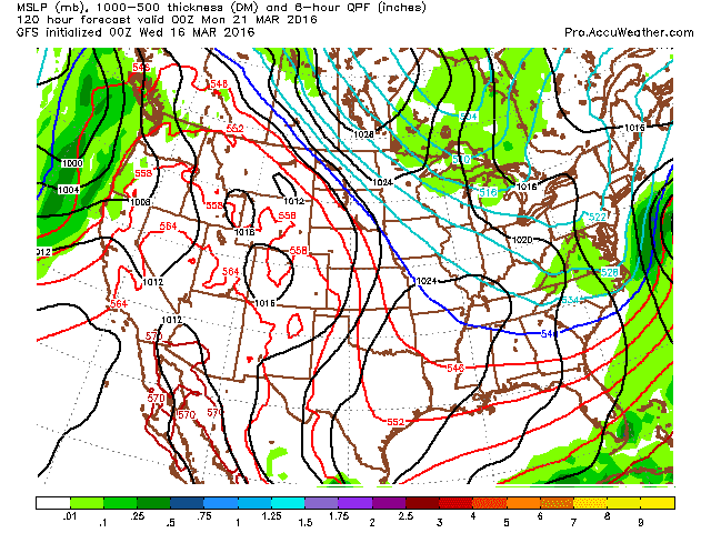
3-16 Halfway through March, DXR is +6.7 temp and has .3" of snow with .6" qpf of normal 4.43. As we go into a pattern change, look for more precip, cooler temps and yes, a chance of snow. Below are the forecast maps for early 3-21. GFS moving towards an overnight, early morning snowstorm, Euro a bit offshore and GGEM moving it to our south, but delivering 1-3"
 |
| 0z Euro |
 |
| 0z GEM/CMC |
 |
| 0z GFS |
 |
| 6z GFS |
 |
| 12z GFS |
Shifting this further west makes sense given further amplification, but just how far west is the question. I could see this turn out as a wet snow/sleet/rain storm. Keeping an eye out for now.


.gif)

No comments:
Post a Comment