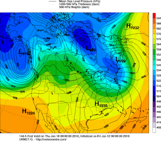
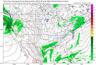
This was the setup at 4am
 |
| 850 temps |
 |
| 925 temps |
It was pouring out. Plows were scraping the bare asphalt too. School was called out. It changed to snow around 6am. Covered the roads. Wet, sloppy snow. 1"so far. its 9am.
The evolution at 500mb has been really poorly modeled. Here is the last 6 runs of the NAM as of 12z 1-17.
This is resulting in slowing that lp off NC and strengthening it.
**********************************************************************
1-16 - Had light snow and flurries yesterday from some ocean affect. Also some flurries this morning
This is how the radar has looked for past 8 hours or so. With some breaking off and heading over our area.
So whats happening...."clippper" system to our west was coming through when it started crawling. It is supposed fall apart and regenerate a new low off the coast. This has caused fits with where the precip should be, particularly on the NAM. Instead of one system to figure, it has to sense where the first storm ends, and second begins. The precip over PA and CNY is clipper/stalled front related. The precip to our east is new storm related. Trend has been for the storm to pull west, but thats not reflected easily in the NAM trend below.
The other challenge has been temps. Not aloft, 850 temps are solid for snow. But with the LP coming further west, it brings in warmer air. But the NAM again is all over the place.
Now temps of 32-33 can still support snow if its falling hard enough. And in the morning hours, it should be. Even the 925 mb temps (2500ft) are jumping around, but if they settle below 0c then I would expect snow over rain. And in heavier bursts, would cool the entire column to freezing.
Last variable would be how warm the surface is at the beginning. A lot of upper 30s and 40s around NYC and the island right now. Those will be hard to overcome. But inland temps are low to mid 30s.
NWS has a pretty good map as does WFSB. I could see NYC 2-4 with island 0-1. NE NJ 2-4 but 4-5 NW. CT coast 2-4 with I84 corridor 3-6.
______________________________________________________________________________
1-12 Pouring rain today. 58 throughout most of CT as I traveled. Dense fog. Snowpack almost gone at home.
Just a look at some Euro snow maps... these are 24 hr snowfalls
 |
| 0z Euro |
 |
| 12z Euro |
NAVGEM takes initial energy from the clipper with some light snow for us, then redevelops just to our east brushing us with more light snow. Navgem rule states that all other modeling should be to its west, so this is a good signal.
NAVGEM also drops the ULL down, but doesn't cut it off anymore, keeping a positive tilt. This is a bad sign for a storm.
UKMET has the ULL even farther west. It keeps the clipper in tact as it goes through the area, then redevelops another storm to our south which sweeps east.
 | |
| 12z ukmet 6hr precip |
| Icon Clipper |
| Icon second storm |
So the upper pattern needs to be figured out....
Gonna need more time for this one.
''''''''''''''''''''''''''''''''''''''''''''''''''''''''''''''''''''''''""""""""""""""""""""""""""""""""""""""""
1-11 After a warm up today and Friday, cold front comes through with some possible sleet at the end of it. Been following on Accu Forums but decided against a blog on it due to the regional nature and we are not getting much if any snow out of it.
However, a clipper and upper air disturbance will be following shortly there after. A lot of model support this morning for this, but there is still time for this to either just not happen or go out to sea. I don't think this can go very far west of us since its spawned offshore.
Euro right now depicts it the strongest. Strong upper low drops down with fresh cold air, spawning a storm off the coast (remnants of a clipper). Pay attention to the blue thickness line, indicating a mix here and rain to the east, which ultimately keeps the snow amounts down east of here.
Seems like a rare scenario - it is. Happens a couple times per winter, sometimes not at all. Is there other support for this? UKMET is least committal, but upper level supports. NAVGEM rule applies as it is the furthest east.
| Icon (German) |
 |
| Ukmet |
 |
| Ukmet precip |
 |
| GFS snow |
 |
| Navgem |
A lot of time for changes - Upper low could be weaker, could drop further west or east.


.gif)

.gif)

2 comments:
Organization of the system seems to have deteriorated significantly in the past few GFS runs... but then again it is GFS vs. CMC, ICON, NAVGEM. Got any thoughts?
Sorry, didn't see the comment. I'd only be looking back in hindsight. GFS might have been the winner here.
Post a Comment