12-23
Every model showing snow now. Dusting to 2". Euro and ICON have the least amounts.
 |
| GFS |
 |
| Canadian Global |
 |
| Canadian Regional |
 |
| Canadian Hi Res |
 |
| NAM |
 |
| NAM hi Res |
 |
| German ICON |
 |
| Euro |
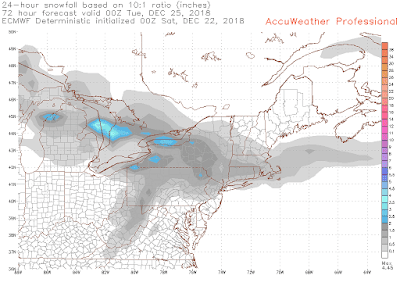
12-22 Still a good chance for light snow. Actually, it should snow, just not sure if its flurries, snow showers or more sustained. Depends how much moisture makes it over the Appalachians. Nothing to be worked up over, just mood flakes. The 2" areas are in blue.
 |
| NAM |
 |
| Euro |
 |
| GFS |
|
12-20 There's a shortwave disturbance that is out there on the Euro for the 12-24 to 12-26 period. Brings a dusting to an inch .
FV3 has it too
12-15 And just like that, the snow opportunities disappear. That storm on the 21st really goes bonkers on the GFS and brings 2+" of rain.
There is a following clipper that drops down behind it, but its very light. Could provide mood snow for Christmas Day, but nothing worse at this point.
FV3 has the 12-21 storm further east and weaker, but the clipper behind completely falls apart.
Euro lacks the clipper altogether.
6z navgem has an interesting solution - keep the southern and northern stream separate, and run the storm in the gulf up the seaboard like a miller a type storm. Weaker storm, but keeps the warm air from coming up. But there isn't a lot of cold air to work with either.
So this mornings update is a green Christmas, possible with mood flakes.
12-13
With Christmas coming into long range on the GFS, FV3 and EPS, will there be snow on the ground, in the air, rain or just green?
Today's FV3 did not disappoint with multiple chances at moderate snow.
EPS from 0z today also looks good with a good size storm on Christmas day
GFS has a big storm as well. The 0z early on the 24th, 6z run late on the 24th into 25th.
We are due for a big storm. Haven't had a storm with over 1" of precip from a storm in one day since Nov 2.


.gif)

No comments:
Post a Comment