 12-9 - towel thrown in on this storm, lucky if we get a bit of snow on the front and back, snow showers if this intensifies as the mets say.

 12/8
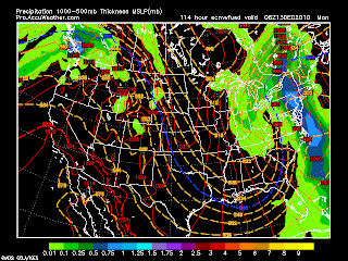
12/8I wasn't going to post anymore for this storm unless things changed. Well, today, overall, it still looks like rain. But I wanted to post the differences in the models for a storm 96 hrs away. Examples will be today's 0z Euro has a 988 low off delmarva and 12z Euro has a 992 low near Buffalo. Then there is the 18 z gfs showing a 1000 low over nyc and later a secondary off the coast, with the r/s line over nw ct v. 12z gfs showing a 976 low, 12hrs later, over nyc, v the 0z run which pulls a 980 low up through w. pa and w. ny.
So our options are euro, either chicago to montreal, or tn to binghamton
GFS - run up north through w pa (988), KY to DXR (976), raleigh to nyc (976), or disorganized to 1000mb over ny, then secondary up the coast. what a mess.
Meanwhile, the ukmet puts a 980 low over E NC at 120 and brings up the coast (0zrun) or brings a 984 low from AL to Chesapeke bay on the 12z run
DGEX morning run goes like the ukmet, then the afternoon, it brings it through like a front, but then bombs out south of LI and over into CT at sub 960!
The only consistent model is the CMC, which has a low forming over the OH valley, moving into PA and heading north - its only off by about 300 miles between runs.
JMA still has straight shot from KY to just South of NYC - its shifted the r/s line a little east from yesterday, but is also consistent.

12/8
I wasn't going to post anymore for this storm unless things changed. Well, today, overall, it still looks like rain. But I wanted to post the differences in the models for a storm 96 hrs away. Examples will be today's 0z Euro, 12z Euro
12/6 - 0z Euro had the storm in W PA and NY.
 12z through Michigan. It was an outlier with the CMA, JMA, DGEX and GFS (0z, 6z, and 12z) runs taking the storm either right over us or just to our east. Then, the 18z GFS shifted west into PA, with no hint of a secondary. So the challenge is does the northern energy take over and it cuts or does it transfer to the coast. The image to the right is the euro which still shows a hint of a southern secondary forming.
All ensembles still hold out hope for this to make it to the coast though. Most bloggers have abandoned the idea of snow from this storm.
This will be the last post unless the storm corrects south or east, but they rarely do.
breaking - 18z dgex concedes western path
As I posted previously, its gonna be that type of winter
12/5 - 0z and 12z Euro showing storm track on Monday to be just to the west of us. Snow, turning to rain. CMC agrees, has more snow on Sat, but also stays colder, even though storm turns north just to the west of us.
Gfs 0z had one storm coming through sat/sun, then another bombing off the coast on Mon with significant snow
6z - minor snow on Sat, then bomb off coast, a bit further east than 0z.
12z - minor snow Sat, then bomb, a bit further east than 6z
18z - still minor snow Sat, but the bomb doesn't go off until way out to sea. But the northern energy will bring some minor snow monday.
12/3

Lets start with the Euro. Todays 0z run had a nice storm forming over the SE, no clipper. The 12z has nothing but brutally cold air.
0z GFS - Storm slides off SE, but clipper comes in behind on the 14th
6z GFS - Weak clipper comes through
12z GFS Weak clipper strengthens as it comes through
18z - nada
CMA - brings weak low across country and explodes over us. Borderline rain/snow.
12/2 - 0z gfs - nothing but a weak clipper for the 12th, then it warms up too much for any snow in the rest of the run.
6z run has an insane 968 low heading to cape cod on the 13th 14th (see pic)
12z run has weak clipper headed right over us, but cold enough for a little snow
18z run phases northern and southern stream right off the coast on the 12th, to a 988 low just off cape cod, giving a few inches.
12z Euro is coming in at 240, looking similar to the 18z run of the gfs, but slower and phasing inland, perhaps so far inland it cuts eventually to lakes. It keeps the clipper stronger and absorbs the southern stream . But this would result in front end snow, even if it turns to rain.
So two models on board with some kinda snow 12-14 of december.
First storm chance 12/13 (if the 12/5 storm goes out to sea)

12/1 - the cold front is approaching - so far a 22mph gust knocked some branches off the tree next door. Otherwise, we are not getting snow for the 2nd.
Latest model runs also either lose or drill south the clipper type storm for the 5th. They do bomb it out just to our east, but only this mornings euro run shows any snow, and thats down around VA.
There is another shortwave coming into CA on Sunday, which the Euro loses, but the GFS brings south into the gulf and way out to sea up the east coast on the 8th/9th.
The GFS does have, and has had this on the last few runs, a nice storm blowing up just off NJ for the 13th. Its looks like a combo of a clipper coming south and a system moving north. It brings it up to the west of CCod and bombs to a 982 low. Then fuels another one on the 15th, just missing us out to sea. And then another shortwave comes through on the 16th.


.gif)

No comments:
Post a Comment