3-23 Reality. Snowing out this morning, grass already covered. WWA up for the area. TWC calls for 6-10, NWS at 3-5, AW at 2, local mets range up to 7". Some in NWNJ, Catskills could see 10+. But, not all that impressive on radar - just a front end band that dried out as it moved into CT and is maybe 75 miles wide now. So it snowed in NJ overnight enough to shut schools, but didn't start here until 7:30. Will have to watch behind that band as its dry now, forcing temps up, but starting to fill in over PA.


Tale of two models
12z runs have dramatic differences - above is NAM v GFS. Whats the difference between 2" and .5" amongst friends. NAM now brings 850 line to south of Trenton. GFS remains in Tappan Zee area. Euro below takes the NAM cold air, and adds a bit to the moisture compared to GFS.

3-21
Snowed today, rather heavy, though only for a few hours and got an inch or so on the grass. Afterwhich the warm front moved through and our high, after the warm front, was 39.
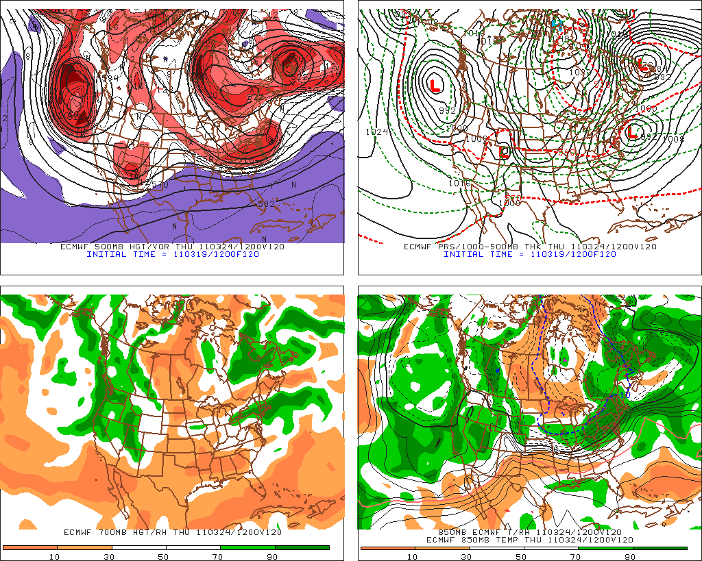
Back to the 23rd...
The 12z Nam runs went nuts. 1.25 in precip for most of NJ, including NYC, with .5 in N CT to 1" in S CT. 0 line at 850 is never further north than Trenton on the 12z .
Euro places 850 line never further north than Central NJ either, but in our area, its lack of precip - between .25 and .5, which means only a few inches. It takes the bulk of the precip between philly and dc.
GFS - 0z run much warmer than the rest - throw it out. The rest go from bringing the 850 line through either NNJ (I78ish) to the NJ/NY border. So per GFS, mostly rain in the NY metro with snow north of the TappanZee. 0z run had1.25 in NW Jersey, with .5 over most of CT. 6z had .75 over West nj with .5 over the rest and .25 in NE ct. 12z had .5 over most of ct and .75 over most of NJ and NYC. 18z had a general .5 over the entire area, so precip is all over the place for the GFS. Ensembles running about 30 miles south of the operational.
JMA has .75, with 850 line through Central NJ.
Nogaps has 850 line along I80.
SREF goes pretty far north into NNJ as well.
CMC keeps line closer to phl, along with most of the precip.
UKMET brings line through central nj, similar to nam.
Todays call: Mixed bag for most of NJ, with NW hills getting more snow than rain, NYC area getting more rain than snow. Too hard to say with surface temps likely 32-35 how much will stick. If it comes down heavy like the 12z nam, it will snow and hard. Extreme NW Jersey, Orange, Rockland ,N Westchester and North of the Merrit in CT seem to be closer to 32 or lower and can pick up 3-6 inches.
One other aspect is timing. I've heard reports of it starting Tues nite and Wed nite. Nam shows it starting in NJ at midday, which will result in it melting on the surface. CT it starts after the rush hour, and with a lower sun angle, can begin to accumulate faster. GFS starts it Wed morning in NJ and in the afternoon in CT. I can't see it sticking much, particularly on roads if that happens. Euro times it closer to the NAM.
3-20 -another quick look - the morning euro looked like a rain event for here south. The afternoon brings the snow line closer to nyc, but with .46 precip. GFS is mixed - with more precip, but temps aloft warming, particularly on the 12z run. Both show the cold persisting in the longer term. CMC had snow on both its runs today!

3-19 - brief update as 12z Euro has 2" of front end snow on Monday, which is going to depend on surface temps, which look to be in mid 30's. Thursday - euro output is .76" with temps all well below 0 at 850 and around 33 at the surface. 12z GFS is a little warmer at 850 on thursday with .68 output. Still signals snow, with boundary temps at 32-33. Scary is the long term gfs which has temps staying in the 30's with below freezing aloft, with multiple storms (nothing huge) coming along every few days. Monday doesn't look like more than an inch from the GFS before changing to rain. Euro cuts precip off before temps increase, which generally has been happening. CMC has thursday being a Philly snowstorm now.


3-18
Models showing storm moreso on Thursday, with most runs bringing snow SOUTH of NYC. Not completely trusting them as ridges in the spring are underdone. CMC run above still has healthy storm.

Winters last gasp once past Tuesday the 22nd. Colder air will move in, but in order to snow will need to be timed correctly. Waves of LP between Tues and Thurs next week are consistent on the models with the cold air sinking south, could end up with some minor snow. Today's runs are the first ones with all three long range models (cmc, euro and gfs) holding the trough in the east. So I bit and put a post up. Images are from the ewall, cmc, euro and gfs
Snowed today, rather heavy, though only for a few hours and got an inch or so on the grass. Afterwhich the warm front moved through and our high, after the warm front, was 39.
Back to the 23rd...
The 12z Nam runs went nuts. 1.25 in precip for most of NJ, including NYC, with .5 in N CT to 1" in S CT. 0 line at 850 is never further north than Trenton on the 12z .

Euro places 850 line never further north than Central NJ either, but in our area, its lack of precip - between .25 and .5, which means only a few inches. It takes the bulk of the precip between philly and dc.
GFS - 0z run much warmer than the rest - throw it out. The rest go from bringing the 850 line through either NNJ (I78ish) to the NJ/NY border. So per GFS, mostly rain in the NY metro with snow north of the TappanZee. 0z run had1.25 in NW Jersey, with .5 over most of CT. 6z had .75 over West nj with .5 over the rest and .25 in NE ct. 12z had .5 over most of ct and .75 over most of NJ and NYC. 18z had a general .5 over the entire area, so precip is all over the place for the GFS. Ensembles running about 30 miles south of the operational.

JMA has .75, with 850 line through Central NJ.
Nogaps has 850 line along I80.
SREF goes pretty far north into NNJ as well.
CMC keeps line closer to phl, along with most of the precip.
UKMET brings line through central nj, similar to nam.
Todays call: Mixed bag for most of NJ, with NW hills getting more snow than rain, NYC area getting more rain than snow. Too hard to say with surface temps likely 32-35 how much will stick. If it comes down heavy like the 12z nam, it will snow and hard. Extreme NW Jersey, Orange, Rockland ,N Westchester and North of the Merrit in CT seem to be closer to 32 or lower and can pick up 3-6 inches.
One other aspect is timing. I've heard reports of it starting Tues nite and Wed nite. Nam shows it starting in NJ at midday, which will result in it melting on the surface. CT it starts after the rush hour, and with a lower sun angle, can begin to accumulate faster. GFS starts it Wed morning in NJ and in the afternoon in CT. I can't see it sticking much, particularly on roads if that happens. Euro times it closer to the NAM.
3-20 -another quick look - the morning euro looked like a rain event for here south. The afternoon brings the snow line closer to nyc, but with .46 precip. GFS is mixed - with more precip, but temps aloft warming, particularly on the 12z run. Both show the cold persisting in the longer term. CMC had snow on both its runs today!
3-19 - brief update as 12z Euro has 2" of front end snow on Monday, which is going to depend on surface temps, which look to be in mid 30's. Thursday - euro output is .76" with temps all well below 0 at 850 and around 33 at the surface. 12z GFS is a little warmer at 850 on thursday with .68 output. Still signals snow, with boundary temps at 32-33. Scary is the long term gfs which has temps staying in the 30's with below freezing aloft, with multiple storms (nothing huge) coming along every few days. Monday doesn't look like more than an inch from the GFS before changing to rain. Euro cuts precip off before temps increase, which generally has been happening. CMC has thursday being a Philly snowstorm now.


3-18
Models showing storm moreso on Thursday, with most runs bringing snow SOUTH of NYC. Not completely trusting them as ridges in the spring are underdone. CMC run above still has healthy storm.


Winters last gasp once past Tuesday the 22nd. Colder air will move in, but in order to snow will need to be timed correctly. Waves of LP between Tues and Thurs next week are consistent on the models with the cold air sinking south, could end up with some minor snow. Today's runs are the first ones with all three long range models (cmc, euro and gfs) holding the trough in the east. So I bit and put a post up. Images are from the ewall, cmc, euro and gfs


.gif)

No comments:
Post a Comment