Looks like I missed one heck of a day, real roller coaster for us here in CT. Out on business all day, just caught up with the printouts. So precip for DXR
GFS went from .69 yesterday at 18z up to 1.19 at 0z; 1.79 at 6z; .99 at 12z and .35 at 18z :angry:
Euro went from .21 yesterday at 12z up to .7 at 0z down to .34 at 12z.
CMC went from 1" yesterday 0z to 1.5 12z down to .75 today 0z and .35 :blink: :( for 12z
I won't ask why or how, but remain hopeful for at least our first inch of pure snow, and that someone, somewhere gets over 36". I still think 6-8 for the southern half of CT, but really not seeing much support in that anymore though NAVGEM and JMA are running NW of previous runs. NYC could still see 8-12, SNJ/PHL still in running for 12-18+. The 1" line on the snowmaps is about 60-70 miles NW of the 12" line - thats a HUGE difference
I'm ill - woke up with headache. Computer screen making me nauseous, not just the runs but staring at it. Hopefully be better tomorrow.
***********************************************************************
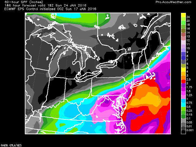
1/19
Afternoon - Euro operational only puts .14" of precip down for Danbury. CMC came in west. 12z GFS looks like double digit accumulation, its in the middle. Ukmet shifted east at 12z and Euro now is the eastern outlyer.
GFS ensembles are concerning as many don't have snow north of Philly. The EPS mean has remained fairly consistent out to sea, but the control is inside the benchmark still.
Most are scratching their heads now, wondering what happened to consensus. The system will be fully onshore overnight. Expect more changes as that system is sampled, not extrapolated.
Morning Cha Cha Cha Changes... but still 6"+
GFS lowered its precip amts to .74 on the 6z run. Euro lowered to .8 on the 0z run. Both had weaker storms which weren't captured as early. Both trended toward yesterday's 18z DGEX which is scary. Meanwhile, the UKMET which was furthest east is now west.


Last map is the GFS from the 6z - which is the main change for CT


Evening - DGEX shows no snow for CT except coast. NJ still gets hit hard, esp southern parts.
Afternoon quick update... Euro further west this run with 1.3qfp all snow for Danbury, but with a 40+ inch dump on VA/WVA. 12z GFS was at 1.26, but colder aloft so better snow ratios. Thats up from .9 at 6z, but still lower than the 1.4" from the 0z run.


Overall, models remain basically the same - 12+ inch storm all the way from VA to Boston with some areas getting 24, 36 or even more...
Morning
All models, except the CRAS, are in agreement that snow will be falling on the 23rd. Some runs are extreme. Lets start with the 0z GFS. It takes the low up and stalls it around ACY 984 or 980. 850 temps well below 0 meaning good snow growth for CT. The result is this:
 |
| Yes that is 36-42 inches in one storm in SEPA |

0z Euro also bullish on snow, to the east of the gfs.
 |
| Euro widespread 12+ with 24+ local |
 |
| DGEX 18+ |


However, even with this odd consensus amongst operational models, the EPS control is slightly east if the operational and the ensemble mean is east. The GFS and CMC ens are also to the east of the benchmark. But as noted in the picture, the spread is biased west. This still affects PHL-DC though.

+++++++++++++++++++++++++++++++++++++++++++++++++++++++++++++++++++++
1/17 We may get some snow today - more interesting is that parts of NC/VA piedmont may end today with more snow for the season so far than us.
Afternoon - 12z GFS limits us to 3" now. CMC though hits us hard with 18+. UKMET getting into range and looking like the Euro, but the 500mb low cuts off a bit sooner.
 |
| 12 Crazy uncle hits NEPA and Westchester/Fairfield |
Morning
For the 23rd, 0z GFS pounded us with precip with 1.6 QPF all as snow, so at least 15 inches. 6z backed off but still puts .6 down as all snow. 0z run had the lp going from AR to WV, then reforming from NC to BM at 984mb. 6z was a little further south than the BM, and weaker at 988, but same scenario. GFS ensembles support the general idea but are a bit south of the operations, with the spread to the NE.
Euro has a different route. Forms over MS, goes weakly over GA/SC, but with a lot of precip. Then craws up the coast. Its at OBX on 12z Sat at 996mb. Its a 976mb low off NJ at 6z Sunday. Precip is a mess though with much of the storm cold enough in CT, but the 850 line goes a bit wonky (see below). 1.42 total QPF with surface temps all below freezing. 925 layer and 700 layer are well below freezing. I'll guess at 8 inches of snow, and some sleet for the euro solution. The Euro ensemble control has a slightly different solution, with the low captured a bit further offshore, with a sharp cutoff of precip. Still with a 12" solution though as shown below. Euro ensemble supports this too, but is further east and a little more progressive.
 |
| swiss cheese 850 temps |
 |
| sharp precip cutoff in Southern NE |
 |
| Snow map - this will change over the days |
DGEX misses off shore. But hits SNJ and dumps on VA/NC Piedmont.

1/16 JMA(1-15) had a storm cutting off to our south and deepening as it headed into our area. Yesterday (and day before) Euro and GFS runs had the storm suppressed, out to sea. CMC went back and forth yesterday with rain and major snow, then this mornings 0z suppressed and 12z a hit. 12z GFS now has picked up on this as threat to the tri state. Euro remains south. JMA meanwhile has headed a bit south after yesterday's bomb. I wonder if the Euro is underdoing the SE ridge.

 |
| 1-15 jma |
 |
| 1-16 JMA |
 |
| GFS ens 12z |


.gif)

No comments:
Post a Comment