Wednesday, July 13, 2011
Real Heat Wave possible
The excess moisture in the ground from spring until now has been using up a lot of the suns energy, with evaporation causing some cooling. However, once that moisture is gone, then the real heat waves can get started. So far this year the high in DXR is 90. IMBY its 89. However, the last few days were in the upper 80's and no rain as dry fronts came through. This sets the stage as we cycle through another nice pattern, leading to the heat wave which the Euro shows for the end of next week. And while that ridge centered over VA brings us the heat, it will also open the Gulf up for activity, although the Euro shows no LP developing at this time. GFS also shows heat wave potential, but no tropical activity


Wednesday, June 29, 2011
Hurricane Season
Hurricane season begins June 1, but we had to wait until June 28 for our first Tropical Storm. As mentioned in the previous post, conditions looked good for development, and sure enough it happened. Arlene should remain a TS and move into Mexico early tomorrow.
As a fun note, our 18th storm will be named Sean. Not thinking we will get that far though.
As a fun note, our 18th storm will be named Sean. Not thinking we will get that far though.
Saturday, June 25, 2011
May/June
After a 1.3+ normal May, with above normal precip, we expected a cool June. Well, we got our first 90 reading in June, on the 8th, forcing Danbury schools to dismiss early. Strong storms following the "heat wave" (two days of temps at 90), brought down trees and power lines, forcing the closing of area schools completely (except Danbury).
June is running below normal temp wise, despite the few days of heat at the start. We've been locked into a pattern where an upper low sits over the lakes, keeping it cool with on and off rain. In the 14 days since the heatwave broke, only 4 had no rain, with no above normal highs.
First signs of hurricane season showing up on the GFS with a TS making landfall around the TX/LA area on the 7th-8th. Not seen on the euro though, not yet at least
June is running below normal temp wise, despite the few days of heat at the start. We've been locked into a pattern where an upper low sits over the lakes, keeping it cool with on and off rain. In the 14 days since the heatwave broke, only 4 had no rain, with no above normal highs.
First signs of hurricane season showing up on the GFS with a TS making landfall around the TX/LA area on the 7th-8th. Not seen on the euro though, not yet at least
Tuesday, March 29, 2011
Opening new entry for April Fool's
3-31 evening jokes on us. Looking downstream on radar, lots of precip heading nne out of NC, but likely sliding out and missing west of nassau cty. It may try to fill in as it deepens and kick back west, and there could still be deformation set up east of the hudson, but not looking good for any accumulating snow. Temp is 34 as I go to bed, and its not doing anything after having a 80/20 mix of rain/snow earlier. Meanwhile, its snowing in New Haven and New London - go figure.
3-31 12z runs are in Euro - colder. East over BM. Only .3 in precip, mostly at below 0 850 temps, but not dynamic enough to support accumulation. GFS - now near BM, .barely 5 precip, mostly at below 850 temp - see euro CMC is hanging in there, per below UKMET - complete miss, OTS Except for the CMC, the models don't deepen this until its past cape cod. With all the components on the playing field and sampled, its hard to argue. 3-6 inches may not hold for DXR anymore. 12z RGEM over BM
  12 gfs precip - shifted east 3-31 Track is still wobbling Things are usually clearer at 12hrs out, but the GFS moved west overnite, causing mostly rain for places within 60 miles of NYC, mix on the fringes, as did the NAM. Euro did not make that adjustment, and neither did the ukmet or cmc. Then the 6z runs of the NAM and GFS were a little east, and then the 12z runs were further east. So the track looks more favorable for some snow, but instead of the storm deepening south of LI, its now not progged to deepen on these to models until its past CCOD. So even though the temps aloft are cooler, there is much less precip - only .5 in DXR and less further west. So less precip means of course less rain or snow. But without the dynamics of the deepening and heavier precip, the ability to draw cold air from the atmosphere means its more difficult to change to snow. Per the 12z NAM and GFS, areas west of NYC may not get much at all. 12z RGEM is out with the low going over the BM, and is more bullish on the precip, but still its far enough east to have NEPA miss heavy precip. Experience shows thought that the precip shield on the models more often spreads further north and west than indicated, so the RGEM looks ok compared to GFS. I'm still with 3-6 for SW CT, 6+ for NW CT. However for NJ, I'm decreasing to 2-4, with 6" only at 1000 feet or higher. Will update when 12z foreign runs are in.
  euro 12z
  ukmet 12z 3-30 Its the track.... 12z runs pushed a bit east, with Euro moving most of W nj, hud val, and ct back into the snow, or at least wet snow range. GFS nudged east, NAM catching on finally, but still east. GFENS are not supporting the GFS with their 850 temps being south of NYC for most of the event, and surface low closer to the BM than Islip. UKMET also shifted east to a snowier solution. No reason to change forecast based on 12z runs. Euro has snow though for Thurs, which I'm doubting will amount to anything. Below is the output for the euro - note surface temps above freezing, 850 is below, but not enough for pure snow, although the critical thickness of 540 is met. day-time--sfc---850---slp---prec--- hgt --- thck
  CMC above
  Gfs precip
  Euro precip
  GFS mslp and 850 line 3-29 Big developments 0z gfs brings stacked low, 980 at surface over NNJ at 18z Friday - rain to snow, mostly rain for tristate 12z moves off coast with 980 over ACK at 18z, stacked, with mostly snow for tristate (mix on the coast), precip 1.25, see pic 0z euro haz 984 low over BM at 18z fri, all snow and precip near 1" 12z euro haz 980 low, closer to Block Island, all snow and precip near 1.5" - winds 30-40, see precip graphic 0z RGEM has 979 low passing just se of BM at 21z, barely glancing us with showers 12z RGEM has 969 low passing over BM, just off CCOD, mostly snow for us. 0z Ukmet brings 984 low se of BM 12z ukmet brings 984 low up into LI by 12z Friday - real close for thickness and 850 line JMA is on board with 990 low parked over Texas Tower, though not closed off. Euro ens support the operational, which is odd. Gfs ens are se of the operational, which is usual. Spread is greatest to the NW. The 850 temps are really cold though. Precip of .5 in the area SREF ens look to take the low just SE of the BM, with the spread to the SW, which indicates the WRF members which I will explain next. Precip of .5 WRF/NAM has the first storm blowing up off the coast, and then just a mess of LP, disorganized coming afterwards. In short, no storm on the NAM at all. This is where some of the other models were a few days ago, but each NAM run is consistent. Even so, the first storm drops .5 in the form of snow, but on Wed nite into thurs. Call - 72 hrs out with a lot of consensus as to something big coming. Its going to be tough in the city and along the coast, but just inland, 3-6 seems assured with a chance for up to a foot. NWS Upton caught on in the afternoon shift, and now lowered temps into the mid 30's with 70% chance of snow. Elevation will matter - could be over a foot in areas over 1000 feet. This event is different than last week. Last week was a weak storm, throwing bursts of snow which could not amount to much. If this stays forecast around 980mb, stacked, it will be strong enough to pull down cold air from aloft, and accumulate. Whats missing is a strong high to the north (instead is a weaker high sliding off, which will still keep in some cold air, but not enough), and the exact track. 18z gfs run just came in and it brings the low closer in, resulting in more rain for the city and coast. Mix inland. We'll see what the nam brings in at 0z- if it catches on or not. NCEP has a 10% chance of over a foot.
3-31 12z runs are in Euro - colder. East over BM. Only .3 in precip, mostly at below 0 850 temps, but not dynamic enough to support accumulation. GFS - now near BM, .barely 5 precip, mostly at below 850 temp - see euro CMC is hanging in there, per below UKMET - complete miss, OTS Except for the CMC, the models don't deepen this until its past cape cod. With all the components on the playing field and sampled, its hard to argue. 3-6 inches may not hold for DXR anymore.
 12z RGEM over BM
 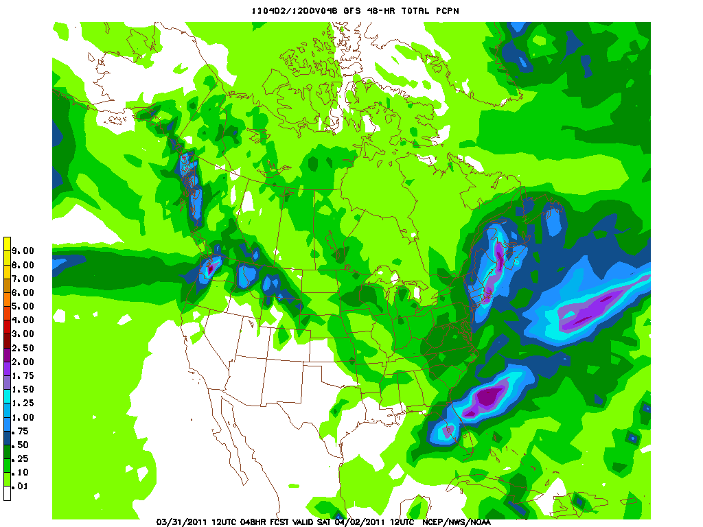 12 gfs precip - shifted east 3-31 Track is still wobbling Things are usually clearer at 12hrs out, but the GFS moved west overnite, causing mostly rain for places within 60 miles of NYC, mix on the fringes, as did the NAM. Euro did not make that adjustment, and neither did the ukmet or cmc. Then the 6z runs of the NAM and GFS were a little east, and then the 12z runs were further east. So the track looks more favorable for some snow, but instead of the storm deepening south of LI, its now not progged to deepen on these to models until its past CCOD. So even though the temps aloft are cooler, there is much less precip - only .5 in DXR and less further west. So less precip means of course less rain or snow. But without the dynamics of the deepening and heavier precip, the ability to draw cold air from the atmosphere means its more difficult to change to snow. Per the 12z NAM and GFS, areas west of NYC may not get much at all. 12z RGEM is out with the low going over the BM, and is more bullish on the precip, but still its far enough east to have NEPA miss heavy precip. Experience shows thought that the precip shield on the models more often spreads further north and west than indicated, so the RGEM looks ok compared to GFS. I'm still with 3-6 for SW CT, 6+ for NW CT. However for NJ, I'm decreasing to 2-4, with 6" only at 1000 feet or higher. Will update when 12z foreign runs are in.
  euro 12z
  ukmet 12z 3-30 Its the track.... 12z runs pushed a bit east, with Euro moving most of W nj, hud val, and ct back into the snow, or at least wet snow range. GFS nudged east, NAM catching on finally, but still east. GFENS are not supporting the GFS with their 850 temps being south of NYC for most of the event, and surface low closer to the BM than Islip. UKMET also shifted east to a snowier solution. No reason to change forecast based on 12z runs. Euro has snow though for Thurs, which I'm doubting will amount to anything. Below is the output for the euro - note surface temps above freezing, 850 is below, but not enough for pure snow, although the critical thickness of 540 is met. day-time--sfc---850---slp---prec--- hgt --- thck
 THU 18Z 5.8 -2.9 1011 0.01 547 539------------------------------------------------------------------------------- This mornings runs all lean toward a massive rain event for the tristate, with snow pushed into NEPA, Catskills and Mass. This is due to the track of the 500 low, 850 low and surface low. Most models place the surface low between NYC and the BM. This brings in warmer air from the ocean to places which would have avoided it if it were closer to the BM. Example - DXR now would have an E or SE wind, instead of a N or NE wind. With the 850 low going over NYC, the areas east will have temps above 0c. There would be some mixing inland, with maybe some minor accum on the front and back end. Now, the NAM is still not looking right, and the ensembles have a perfect placement for a major snowstorm for the N and W subs of NYC. I'll still stick with a 3-6 inch storm here and in the NW subs, with over a foot in higher elevs as mentioned above. If storm moves further east, will have to go all rain.
FRI 00Z 3.3 -1.0 1009 0.05 546 539
FRI 06Z 2.2 -0.1 1003 0.18 543 540
FRI 12Z 1.2 -1.6 995 0.55 536 540
FRI 18Z 1.5 -4.6 991 0.36 529 536
SAT 00Z 1.5 -5.4 994 0.17 527 532
 CMC above Gfs precip Euro precip
  GFS mslp and 850 line 3-29 Big developments 0z gfs brings stacked low, 980 at surface over NNJ at 18z Friday - rain to snow, mostly rain for tristate 12z moves off coast with 980 over ACK at 18z, stacked, with mostly snow for tristate (mix on the coast), precip 1.25, see pic 0z euro haz 984 low over BM at 18z fri, all snow and precip near 1" 12z euro haz 980 low, closer to Block Island, all snow and precip near 1.5" - winds 30-40, see precip graphic 0z RGEM has 979 low passing just se of BM at 21z, barely glancing us with showers 12z RGEM has 969 low passing over BM, just off CCOD, mostly snow for us. 0z Ukmet brings 984 low se of BM 12z ukmet brings 984 low up into LI by 12z Friday - real close for thickness and 850 line JMA is on board with 990 low parked over Texas Tower, though not closed off. Euro ens support the operational, which is odd. Gfs ens are se of the operational, which is usual. Spread is greatest to the NW. The 850 temps are really cold though. Precip of .5 in the area SREF ens look to take the low just SE of the BM, with the spread to the SW, which indicates the WRF members which I will explain next. Precip of .5 WRF/NAM has the first storm blowing up off the coast, and then just a mess of LP, disorganized coming afterwards. In short, no storm on the NAM at all. This is where some of the other models were a few days ago, but each NAM run is consistent. Even so, the first storm drops .5 in the form of snow, but on Wed nite into thurs. Call - 72 hrs out with a lot of consensus as to something big coming. Its going to be tough in the city and along the coast, but just inland, 3-6 seems assured with a chance for up to a foot. NWS Upton caught on in the afternoon shift, and now lowered temps into the mid 30's with 70% chance of snow. Elevation will matter - could be over a foot in areas over 1000 feet. This event is different than last week. Last week was a weak storm, throwing bursts of snow which could not amount to much. If this stays forecast around 980mb, stacked, it will be strong enough to pull down cold air from aloft, and accumulate. Whats missing is a strong high to the north (instead is a weaker high sliding off, which will still keep in some cold air, but not enough), and the exact track. 18z gfs run just came in and it brings the low closer in, resulting in more rain for the city and coast. Mix inland. We'll see what the nam brings in at 0z- if it catches on or not. NCEP has a 10% chance of over a foot.
Wednesday, March 23, 2011
Last one - 31st?
0z euro output - note temps are marginal, but precip is rather3-29 morning - euro and gfs in unholy alliance with noreaster on friday.
great
time surfac 850 press hum precip thck height
06Z 01-APR 2.6 -1.5 1009 78 29 0.00 546 538
12Z 01-APR 1.6 -2.0 1003 85 90 0.14 540 538
18Z 01-APR 1.8 -1.9 998 89 91 0.67 533 535
00Z 02-APR 1.6 -4.2 999 91 96 0.31 530 531
06Z 02-APR -0.8 -3.2 997 93 75 0.02 529 531
Timing is critical as gfs is earlier and overnite resulting in 6+ snow
Euro is later and falls mostly during the day, which should limit accums
12z gfs showing slightly colder temps than euro. Both produce around an inch
of precip.
DGEX, UKMET and CMC are out to sea. NAM doesn't have the storm.


3-28
 Somethings coming.... using accuweather graphics today.
Ukmet runs today showed the worst case scenario with a stacked lows, cut off and 970 mb. It stood alone in its severity, with the DGEX coming in next with a 976 low parked off shore, and over 18 inches of snow for the tristate. GFS has various solutions, all giving at least CT some snow, with the bullseye generally around Springfield MA. It only goes to about 980. Euro is very odd with a low off NC/VA that stalls from thurs morn into fri afternoon. But finer resolution on accuweather pro shows why - its two different storms. More of a brushing by for us, but still bringing snow. It only goes to 1008 mb. JMA, just to be different, cuts it up over Pittsburgh. GFS Ens are frightening at 12z, but the other runs have it going SE of the BM. CMC is out to sea with both today.
Call - not looking like a nice way to end the week. If its a month ago, even two weeks, its definitely a snow storm. But with warmer air around, it may snow like crazy and not accumulate. If its precipitating on Friday as heavy as it looks, then its also not going to be in the 40's or 50's. I'm thinking heavy wet snow for here, with N Ct and higher elevs getting 3-7 inches. Here, if at night, we could get the same.
Order of pix should be dgex snow, ukmet, gfs 12z and gfs 18z, dgex slp


3-27 A Tale of two Euros
3-31 and 4-1 pix with two different solutions. So either a minor storm on Thurs (0z run) or major storm on Sat (12z)
Models of no use - GFS is all over the place. CMC is the most consistent, bringing snow on Th and Sat. DGEX has the same.
NWS has nothing forecast

3-25 The overnight and morning gfs runs have the storm still, as does the ukmet. DGEX, JMA has it going to our south, CMC, Nogaps and Euro don't have anything organized, but do have a wave going to our south. update: 12z Euro now has minor storm similar to 0z gfs. 12z ukmet flipped to the 0z euro solution.
3-23 evening. All afternoon runs of the models below no longer have any storms - any moisture goes east south of NC.


3-23 - euro, GFS. DGEXand CMC all have a Low off the coast on 3/30-31. 850 temps support snow here.
Saturday, March 19, 2011
Timing of high temperature thresholds
I heard lots of talk as to how unusual the warmth we had on Friday (71F) was. Made me look up the first days we have hit 60,70,80 and 90 in the past ten years. Its not unusual at all.
| Year | 60 | 70 | 80 | 90 |
| 2002 | 29-Jan | 3-Apr | 16-Apr | 17-Apr |
| 2003 | 16-Mar | 29-Mar | 15-Apr | 24-Jun |
| 2004 | 1-Mar | 26-Mar | 19-Apr | 9-Jun |
| 2005 | 14-Jan | 15-Apr | 20-Apr | 25-Jun |
| 2006 | 18-Jan | 10-Mar | 20-Apr | 29-Apr |
| 2007 | 6-Jan | 6-Jan | 23-Apr | 26-Jun |
| 2008 | 8-Jan | 10-Apr | 18-Apr | 7-Jun |
| 2009 | 11-Feb | 17-Apr | 25-Apr | 17-Aug |
| 2010 | 16-Mar | 19-Mar | 7-Apr | 26-May |
Thursday, March 17, 2011
Near the end
3-23 Reality. Snowing out this morning, grass already covered. WWA up for the area. TWC calls for 6-10, NWS at 3-5, AW at 2, local mets range up to 7". Some in NWNJ, Catskills could see 10+. But, not all that impressive on radar - just a front end band that dried out as it moved into CT and is maybe 75 miles wide now. So it snowed in NJ overnight enough to shut schools, but didn't start here until 7:30. Will have to watch behind that band as its dry now, forcing temps up, but starting to fill in over PA.


Tale of two models
12z runs have dramatic differences - above is NAM v GFS. Whats the difference between 2" and .5" amongst friends. NAM now brings 850 line to south of Trenton. GFS remains in Tappan Zee area. Euro below takes the NAM cold air, and adds a bit to the moisture compared to GFS.

3-21
Snowed today, rather heavy, though only for a few hours and got an inch or so on the grass. Afterwhich the warm front moved through and our high, after the warm front, was 39.
Back to the 23rd...
The 12z Nam runs went nuts. 1.25 in precip for most of NJ, including NYC, with .5 in N CT to 1" in S CT. 0 line at 850 is never further north than Trenton on the 12z .
Euro places 850 line never further north than Central NJ either, but in our area, its lack of precip - between .25 and .5, which means only a few inches. It takes the bulk of the precip between philly and dc.
GFS - 0z run much warmer than the rest - throw it out. The rest go from bringing the 850 line through either NNJ (I78ish) to the NJ/NY border. So per GFS, mostly rain in the NY metro with snow north of the TappanZee. 0z run had1.25 in NW Jersey, with .5 over most of CT. 6z had .75 over West nj with .5 over the rest and .25 in NE ct. 12z had .5 over most of ct and .75 over most of NJ and NYC. 18z had a general .5 over the entire area, so precip is all over the place for the GFS. Ensembles running about 30 miles south of the operational.
JMA has .75, with 850 line through Central NJ.
Nogaps has 850 line along I80.
SREF goes pretty far north into NNJ as well.
CMC keeps line closer to phl, along with most of the precip.
UKMET brings line through central nj, similar to nam.
Todays call: Mixed bag for most of NJ, with NW hills getting more snow than rain, NYC area getting more rain than snow. Too hard to say with surface temps likely 32-35 how much will stick. If it comes down heavy like the 12z nam, it will snow and hard. Extreme NW Jersey, Orange, Rockland ,N Westchester and North of the Merrit in CT seem to be closer to 32 or lower and can pick up 3-6 inches.
One other aspect is timing. I've heard reports of it starting Tues nite and Wed nite. Nam shows it starting in NJ at midday, which will result in it melting on the surface. CT it starts after the rush hour, and with a lower sun angle, can begin to accumulate faster. GFS starts it Wed morning in NJ and in the afternoon in CT. I can't see it sticking much, particularly on roads if that happens. Euro times it closer to the NAM.
3-20 -another quick look - the morning euro looked like a rain event for here south. The afternoon brings the snow line closer to nyc, but with .46 precip. GFS is mixed - with more precip, but temps aloft warming, particularly on the 12z run. Both show the cold persisting in the longer term. CMC had snow on both its runs today!

3-19 - brief update as 12z Euro has 2" of front end snow on Monday, which is going to depend on surface temps, which look to be in mid 30's. Thursday - euro output is .76" with temps all well below 0 at 850 and around 33 at the surface. 12z GFS is a little warmer at 850 on thursday with .68 output. Still signals snow, with boundary temps at 32-33. Scary is the long term gfs which has temps staying in the 30's with below freezing aloft, with multiple storms (nothing huge) coming along every few days. Monday doesn't look like more than an inch from the GFS before changing to rain. Euro cuts precip off before temps increase, which generally has been happening. CMC has thursday being a Philly snowstorm now.


3-18
Models showing storm moreso on Thursday, with most runs bringing snow SOUTH of NYC. Not completely trusting them as ridges in the spring are underdone. CMC run above still has healthy storm.

Winters last gasp once past Tuesday the 22nd. Colder air will move in, but in order to snow will need to be timed correctly. Waves of LP between Tues and Thurs next week are consistent on the models with the cold air sinking south, could end up with some minor snow. Today's runs are the first ones with all three long range models (cmc, euro and gfs) holding the trough in the east. So I bit and put a post up. Images are from the ewall, cmc, euro and gfs
Snowed today, rather heavy, though only for a few hours and got an inch or so on the grass. Afterwhich the warm front moved through and our high, after the warm front, was 39.
Back to the 23rd...
The 12z Nam runs went nuts. 1.25 in precip for most of NJ, including NYC, with .5 in N CT to 1" in S CT. 0 line at 850 is never further north than Trenton on the 12z .

Euro places 850 line never further north than Central NJ either, but in our area, its lack of precip - between .25 and .5, which means only a few inches. It takes the bulk of the precip between philly and dc.
GFS - 0z run much warmer than the rest - throw it out. The rest go from bringing the 850 line through either NNJ (I78ish) to the NJ/NY border. So per GFS, mostly rain in the NY metro with snow north of the TappanZee. 0z run had1.25 in NW Jersey, with .5 over most of CT. 6z had .75 over West nj with .5 over the rest and .25 in NE ct. 12z had .5 over most of ct and .75 over most of NJ and NYC. 18z had a general .5 over the entire area, so precip is all over the place for the GFS. Ensembles running about 30 miles south of the operational.

JMA has .75, with 850 line through Central NJ.
Nogaps has 850 line along I80.
SREF goes pretty far north into NNJ as well.
CMC keeps line closer to phl, along with most of the precip.
UKMET brings line through central nj, similar to nam.
Todays call: Mixed bag for most of NJ, with NW hills getting more snow than rain, NYC area getting more rain than snow. Too hard to say with surface temps likely 32-35 how much will stick. If it comes down heavy like the 12z nam, it will snow and hard. Extreme NW Jersey, Orange, Rockland ,N Westchester and North of the Merrit in CT seem to be closer to 32 or lower and can pick up 3-6 inches.
One other aspect is timing. I've heard reports of it starting Tues nite and Wed nite. Nam shows it starting in NJ at midday, which will result in it melting on the surface. CT it starts after the rush hour, and with a lower sun angle, can begin to accumulate faster. GFS starts it Wed morning in NJ and in the afternoon in CT. I can't see it sticking much, particularly on roads if that happens. Euro times it closer to the NAM.
3-20 -another quick look - the morning euro looked like a rain event for here south. The afternoon brings the snow line closer to nyc, but with .46 precip. GFS is mixed - with more precip, but temps aloft warming, particularly on the 12z run. Both show the cold persisting in the longer term. CMC had snow on both its runs today!
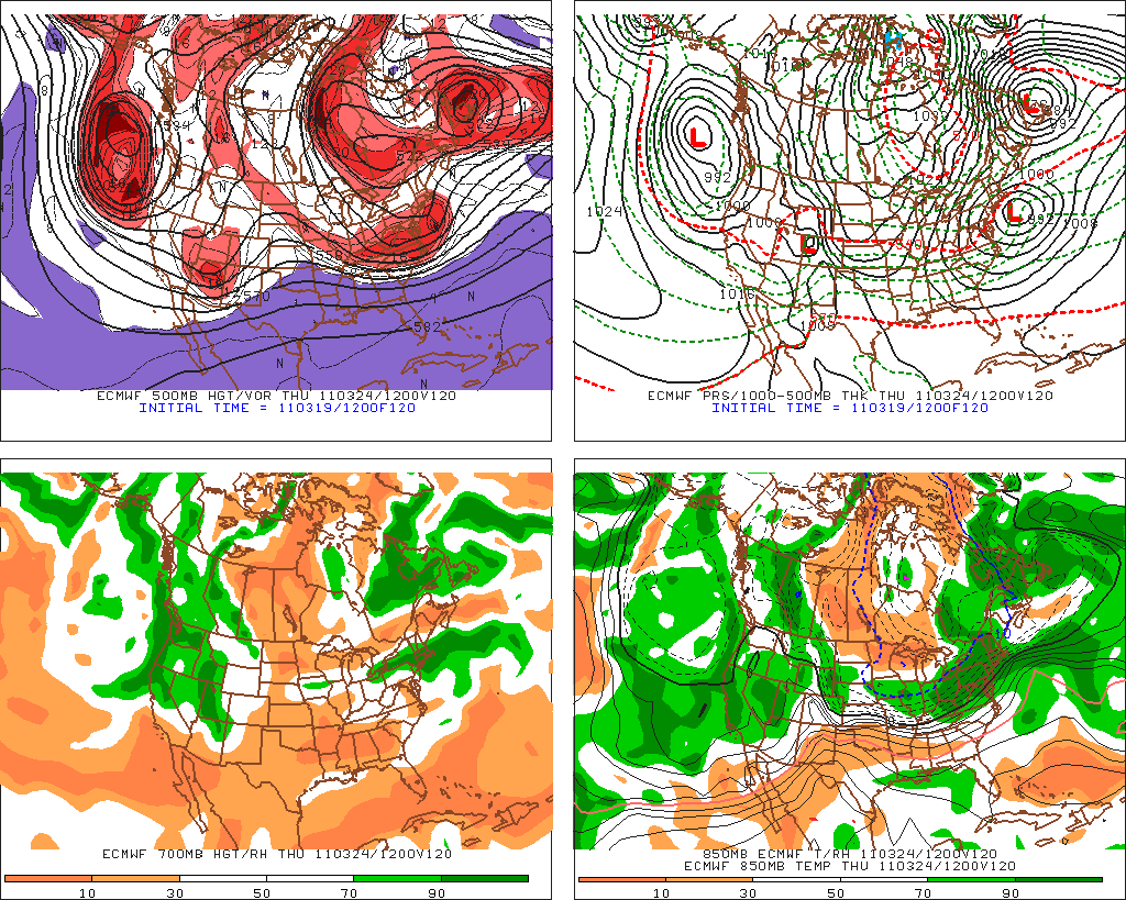
3-19 - brief update as 12z Euro has 2" of front end snow on Monday, which is going to depend on surface temps, which look to be in mid 30's. Thursday - euro output is .76" with temps all well below 0 at 850 and around 33 at the surface. 12z GFS is a little warmer at 850 on thursday with .68 output. Still signals snow, with boundary temps at 32-33. Scary is the long term gfs which has temps staying in the 30's with below freezing aloft, with multiple storms (nothing huge) coming along every few days. Monday doesn't look like more than an inch from the GFS before changing to rain. Euro cuts precip off before temps increase, which generally has been happening. CMC has thursday being a Philly snowstorm now.


3-18
Models showing storm moreso on Thursday, with most runs bringing snow SOUTH of NYC. Not completely trusting them as ridges in the spring are underdone. CMC run above still has healthy storm.


Winters last gasp once past Tuesday the 22nd. Colder air will move in, but in order to snow will need to be timed correctly. Waves of LP between Tues and Thurs next week are consistent on the models with the cold air sinking south, could end up with some minor snow. Today's runs are the first ones with all three long range models (cmc, euro and gfs) holding the trough in the east. So I bit and put a post up. Images are from the ewall, cmc, euro and gfs

-
 11/27 update - happy thanksgiving. GFS has gone from major noreaster, to huge cutter to lakes and now has a minor clipper system sinking do...
 -
.gif) 2/9 Set up is an upper low over TX that heads northeast into TN valley and then transfers off the coast. At the upper levels, there's ...
2/9 Set up is an upper low over TX that heads northeast into TN valley and then transfers off the coast. At the upper levels, there's ... -
 2/22 - results 5.25 inches. Snow started at 2, lasted 12 hrs with varying intensity and types of snow. Kudos for the models, weather serv...