1-8 Still west, no changes. There might be some frozen, lite, precip at the onset Sat morning. The 13th still looks good on Euro and GFS for an inch or less.
1-7 Still west. Euro and GFS are looking at a clipper type, or even just an UL disturbance for the 13th which may give us our first true dusting-2". A storm develops off shore from that arctic blast coming in which should be watched, but should stay offshore, except for the Cape and Maine.
| GFS surface |
| Euro upper level |
1-6 All major models, Euro, GFS, Canadian, UKMET and NAVGEM have this storm to our west. Even NAVGEM which typically has an east bias is over NYC. Perhaps the idea of a double barrel low or a secondary forming comes back into play, but the main storm, which had devolved to a 1000mb low over the lakes, is now down to 988 on the gfs and 996 on the Euro.
Watch out for snow showers/squalls as the next blast of cold air comes in, along with some upper level disturbances. These may be during this time period, but are unrelated to the storm being watched.
1-5 afternoon
12z Euro back on board with the storm. Has it to our west, but its there again. goes from 1000mb over VA to 982 over Maine. CMC is back on board as well pushing its storm from this morning a little further east, but still rain. Ukie moves a bit east too. Can't tell temps that far out though.
1-5 Not much improvement so far today.
0z GFS takes weak LP from OK to Chicago on the 9th, with warm front moving over our area. 850s well to our north. Weak secondary forms late on the 9th but its way too warm aloft. Cold front moves through on the 10th. Nothing follows until the 18th which goes well to our south.
6z GFS looks similar to 0z, but does have the trailer on the 12th and another on the 13th way off shore. I like it when the GFS is offshore this far out, but I don't see anything to bring it back west at this point. Some general snow showers on the 18th, but that's it for really any precip.
12z GFS more organized secondary forming off the coast on the 9th. But the warm and cold fronts are moisture starved. This run seems a bit cooler, but don't have all the data in for it yet.
0z Euro has first storm going up through the lakes like the GFS, but really limited warm front. Keeps it messy (rainy/foggy) in our area through the 9th and 10th. Then the second storm forms much further north than the original gulf formation. It does tap the GOM for moisture and heads up over Erie PA. So heavy rain on the 10th. There's some cold air behind it, but just snow showers. EPS out to 15 days shows more sustained cold after the 10th, with mostly normal to below normal temps, but no organized systems.
CMC still has a storm moving over us, very warm though.
JMA has nothing interesting to add.
0z UKMET has a 988 low heading over us from the Gulf. It'd be rain, but its not like the other models which went from 970 lows to 1012 lows.
+++++++++++++++++++++++++++++++++++++++++++++++++++++++++++++++
1-4 Nice snow squalls in Eastern CT and RI, ocean effect on the Cape, flurries on the way to work and 23 at noon. Winter finally made it. Nothing trending well for the upcoming storm.
Model summary as of 1:30pm
0z GFS LP heads to the lakes on the 9th, with a "warm" front from that storm moving over us. The 850 line is through northern CT at that time and a secondary is trying to form. 540 thickness shows snow. Surface temps above freezing though, as is the 925mb 0 line, so if it snows, its melting and very wet. The follow up storm for the 11th goes out to sea.

6z GFS LP heads up to the lakes on the 9th with only hints at a secondary forming on the coast. Follow up storm for the 11th heads out to sea, never gets its act together.
12zGFS LP heads to lakes on the 9th.. secondary forms off coast, with 850 line through CT and then in MA. Follow up storm forms over AL now (the LP over the lakes no longer lingers and moves on out) and heads quickly up the Apps to NYC by 6z the 11th. 850 line runs through MA at first. Albany should get some good snow, none in our area though.
 |
| 12z GFS for the 11th |
I tend to not like when the Euro is west of the GFS, though its still 7 days out.
FWIW - 12z Canadian operational is similar to the Euro, though it forms a secondary storm on the 11th right over NYC to ME. But its too late by then. Contrasted with the 0z run which had a coastal
just inside the benchmark. Japanese model went from a coastal storm on the 1-3 run to a GL storm today as well.
+++++++++++++++++++++++++++++++++++++++++++++++++++++++++++++++
1-3 Afternoon 12z Euro now takes the storm just to the west of us at 984mb resulting in rain, but there is another for the 15th.

12z GFS goes with a two low solution, one over KS one over the gulf on the 7th. By the 9th, the storm is still only over IA/MO but the gulf one is coming up the coast. By the 10th the orig low is over WI and the other one is off NJ with a mixed bag. You can also see the next one in the gulf. 
After that the one in the gulf on the 10th rides up off obx by the 11th and misses just to our east.
1/3 Morning runs - very interesting, but not a lot of agreement between Euro ens control and operational, nor the 0z and 6z GFS. If you like snow, 0z Euro operational and 0z GFS are for you.
EPS showing this as a cutter to the lakes on the ninth. It also shows another round of really cold air afterwards, and a weak storm hitting us on the 15th with snow before it warms up again to slightly above seasonable temps. Euro operational shows a nice looking coastal storm in the pocket on the 11th after the cutter to the lakes on the 9th. The storm is from energy entering So Cal on the 7th and swinging through Mexico/Texas and into the gulf, then up the coast. It seems warm on the surface map, but the 850 temps are well below 0c. Snow map showing 1-3 for NYC north.

0z GFS run looks facinating. Has the storm blocked over the lakes with a secondary forming (unlike the 6z run) just in time for inland sections potentially. Then like the Euro, it rotates the energy from So Cal through Mexico and up the coast. This results in two snow opportunities, but both are a close call with temps. Also featured is an inverted trough between the two, then a 968 low over the benchmark assaulting us with snow and wind.
 |
| round one with secondary storm forming |
 |
| inverted trough makes snow linger, note storm in gulf. |
 |
| major southern new england/long island storm |
 | |
| snow map 0z gfs |
6z GFS brings a storm from IA to the lakes, slowly from the 8th to the 10th. It doesn't make much of the southern system as the Euro does, but does try to form a secondary storm a little bit to late for us. The energy from the second storm on the 11th is there, but it just doesn't develop it as the Euro or 0z gfs does.

+++++++++++++++++++++++++++++++++++++++++++++++++++++++++++++++++
1/2 - Time frame moving up a little as storm develops in front of the one I've been watching.
0z GFS on 1/9 has 2 lows, 1 over Milwaukee and 1 east of OBX. 540 line is essentially I-90
On 1/11 there is a 980 low over Albany. Neither bring us snow.
12z GFS for 1/9 has a 996 low just south of the 40/70 benchmark, but the 540 line runs from Montreal to Detroit. Very warm, and odd.
1/11 has that storm going out to sea. Next chance on 1/14 with a 1008 low south of LI with the 540 line south of Cape May.
0z Euro has two lows - one over Chicago and one over Jax on the ninth. Neither affect us in an organized fashion.
12z Euro has two lows - one over Milwaukee and VA, going to NYC on 1/9. No feature for the 11th.
Both models show cold, but the EPS and GFS don't make it last. Here is what mid Jan looks like at 850.
 |
| Euro eps 1-17 |
 |
| GFS 1-18 |
++++++++++++++++++++++++++++++++++++++++++++++++++++++++++++++
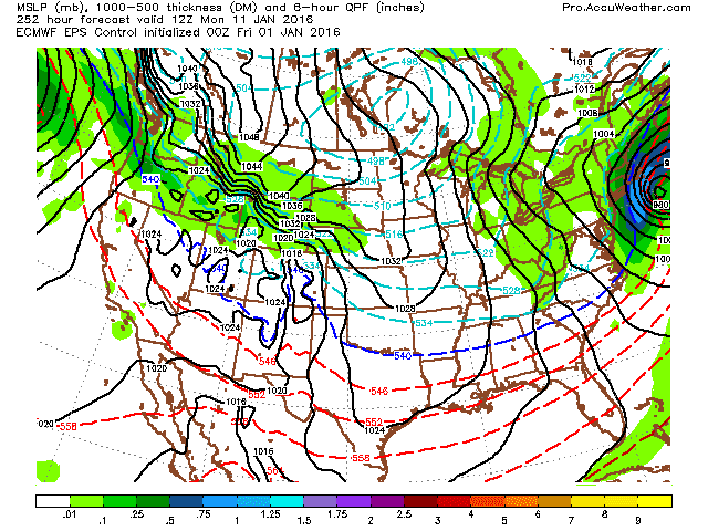
1/1 Time frame still looking good for some activity. European showing a storm on both EPS and at hr 240 on the operational model. However,its mild, despite a track to the south. This bears watching - either to correct the track, or the warmth. January storms to our south don't result in rain, and the EPS track/precip type scenario makes more sense. After a brief below normal day 4-5th, it warms back up before the 11th. After the 11th a wider, deeper trough envelops most of the country. There could be a good storm around the 16th-17th when that trough lifts out.
 |
| Euro |
 |
| EPS |
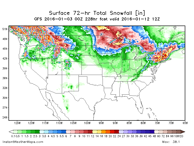
6z GFS takes a 1008 poorly organized low from TX, MO to OH before it reforms to our south offshore with mixed bag - again its not cold enough for that track. But... a second storm ejects from the Gulf, rides up the Apps to offshore of NJ and just inside the BM on the 12th. That is a fun one to watch. There should be just enough cold air for our first good 6+ inch snow, at least inland.
 |
| 6z gfs mixed bag, snow inland |
 | |
| 0z gfs snow north of Trenton |
0z CMC stays mostly warm with an unorganized system moving through on the 10th with rain.
++++++++++++++++++++++++++++++++++++++++++++++++++++++++++++++++++
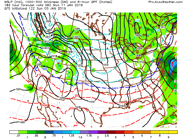
12/31 - I don't like posting forecasts not within hr 240 (10 days) since they almost never pan out, but the lack of activity is driving me nuts. The pattern is changing, and there should be some swings of cold and warmth, but no 55+ degree days or below 0 temps for the next two-three weeks. Overall, probably within a few degrees of normal, perhaps a bit below as we end January.
The Jan 10-12 time period has been interesting over the last few days with a storm consistently approaching or hitting during those days. Euro EPS and GFS have been showing it over the last few runs, albeit in different positions. Here are some graphics from today
 |
| 0z gfs |
 |
| 6z gfs |
 |
| EPS Control 0z |


.gif)

No comments:
Post a Comment