Monday, November 28, 2011

Why no winter yet...

12-9 - Still no pattern change, although models aren't showing blowtorch warmth either.  Around the 19th, we may get some normal air masses to settle in, which by then is all we for some white stuff.  Three to Four storm possibilities between now and Christmas.  First obviously going to the lakes, but a normal progression is to bring each one further and further south.  See first model run with storm on Christmas

12-8  Still no pattern change.  The end of the period still shows return to neutral, but that return keeps getting pushed off.  How long can an AO remain positive?


12-5 - Yesterday's outlook looked favorable for a pattern flip, but out of caution, I didn't post. I'd like to see 3 or more days of a sustained cold, in at least 3 days of model runs before I am convinced the end of the warm pattern is near. This mornings runs have the cold remaning transitory, and while they have the nao and ao approaching neutral, this is much higher than what it was yesterday. The AO currently is 5 right now, the highest I've seen - keeps the cold bottled up in the artic. The PNA however, has been consistently forcasted to go positive since the 12-1 post below, so there will be some cold entering from Western Canada, but it moves fast and modifies as it exits over the Rockies. For the east to be cold, need the cold air coming in east of the Rockies. Lots of talk about storms for this week - just not seeing it though. One cuts west, the trailer goes off east. Possible flurries or quick changeover as front comes through, but doubtful it sticks.

noon disco- NAM does show a snow event wed nite into thurs. Normally the NAM runs a bit north of the other models, but its something to watch now. CMC and GFS both have storms, but a little to far out to sea. 0z UKMET has a storm going right over us bringing rain. Opening separat post on event as more data is coming in.

---------------------------------------
12-1 update: this afternoon had ensembles for 12-15 with +pna, ao and nao heading -. GFS operational completely the opposite though. JB posted yesterday that "the ugliest pre dec 15 week in us since 2005 is on its way" HM posting that 60% of the country could be covered with snow and there will be an east coast storm next week. Now the models have been showing a storm in the dec 6-8 range, but its been cutting west of the Apps.

-------------------------------------------------------------------------------

Below are the major winter indices: Artic Oscilation (AO), Pacific North America (PNA) and North Atlantic (NAO) as forecast by the GFS today. Typical cold patterns have a postive PNA to set the ridge in the East Pacific so cold air comes into CONUS. AO as negative to release the cold air from the pole and NAO negative to keep the cold air around. While the PNA is currently positive, the NAO is really high and AO is really high. Then PNA goes negative. Also note the error pattern on the NAO and AO. The bold line is the actual, grey line is the consensus. When looking at the 10 and 14 day charts, the typical bias since Sept 1 is that the predicted consensus is lower than the actual and for today its much lower. So until we can change at least the AO to a strong negative, no real brutal or sustained cold air masses.

Friday, November 18, 2011

Analogs

Throwing an idea out there - we've had a wet early fall, so what other years have been wet or had a wet fall and how did the following winter turn out temp wise

Wettest Aug/Sept/Oct periods were:
1927 – 22.8 warmer
1933 – 21.46 cooler
1989 – 22.85 warmer 1c
2005 – 21.17 warmer 2c
1983 – 20.56 warmer .5c
1955 – 20.4
1934 – 17.55 (cooler .5)

Wettest years with over 60" of precip by October were:
1972 – 67.03 (Warmer 1c)
1975 – 61.21 (Warmer .5c)
1983 – 80.56 (Warmer .5c)
1989 – 65.11 (Warmer 1c)
1990 – 60.92 (Warmer 5c)
2007 – 61.7 (Warmer 3c)

Overwhelming indication that the DJF period will be warmer than normal

11-26 note: arguing against analogs is my three month cycle theory. JUN/JUL/AUG were below norm with SEPT/OCT/NOV above normal. This would lead to a below norm for DEC/JAN/FEB.

12-13 note:  as of right now, there is no snow in the long range models for the rest of the month.  Using Poughkepsie stats, here are some other years without snow in December and how they turned out:
2006 - Jan('07) 1.5; Feb 17.5; Mar 3.2  note Dxr had 8.3 in Feb
1994  - Jan ('95) 0;  Feb 4; Mar 0

And years with under 1.5 inches:
2004 - Jan(05) 22; Feb 11; Mar 16
1999 - Jan(00) 6.4; Feb 2.1; Mar 0
1998 - Jan (99) 15.9; Feb 1.5; Mar 1.9
1997 - Jan (98) 0; Feb 13; Mar 1.6

Out of those years, 98 and 99 were dry at POU, although other stations were closer to normal. 
There are no years to compare where we got 17 inches in October.

Monday, November 14, 2011

Winter??

11-26 While there are hints of at least a 3 day period of below normal temps at some point in second week, those hints are not yet consistent. Euro and CMC show very little cold air, with 540 lines right over us as the coldest. GFS still shows a trough digging in the eastern half of the country, but it lasts three days. Keep in mind normal temps for Dec are 45 to start 35 to end. It does look a bit closer to normal compared to what has happened lately though. With Nov, Oct and Sept being above normal, it should switch to colder soon. Unless you read my analog post.
No model has any threat of snow for next ten days. Will post again once trough becomes established or if storm threat arises.

11-22 Watching long range models which have been showing cold air invasion in week two, but keeps trending to splitting the trough and pumping warmth in. No evidence that even if the cold air gets here, that it stays for over a few days. Watching highs develop over OK/TX and moving NE over Mid Atlantic. Not a cold pattern. Will check in after Thanksgiving.

11-18

Still a borderline snow event for Tues, Wed before Thxgvg. Just a matter of whether the storm goes flat and underdeveloped, or if it amplifies and winds up (and where it deepens as well). Nothing very strong in any event.

11-14

Asided from a temporary cold blast or two from frontal passages, no colder than normal weather or snow is in the next two weeks. I am keeping an eye on the time period around Thanksgiving as there could be enough cold air aloft to bring some wet snow, but its not quite as impressive as the Oct. storms.

Tuesday, November 1, 2011

October snow results


Snow started in Danbury around 11am per facebook posts. Lasted until the middle of Saturday night. NWS official total was 17.2 inches for Danbury. Power went out at the airport around 3pm and went out at the weather station around 7:30. As of this writing three days later, power has not returned. At the peak, 850,000 CL&P customers (66%) lost power. All of New Fairfield, Ridgefield, Redding, over 95% of Bethel, Newtown and 66% of Danbury lost power. Those totals have only moved down slightly three days later. Temp in the house bottomed out at 48 degrees and has stayed there for the most part. The bedroom was heated to 59 using 15 candles last night. We lost limbs off the front maple, which crushed the forsythia, we lost a wygelia, spirea, butterfly bush, branches off a lilac, an entire lilac in the back, an entire dogwood, a third of another dogwood, prized rosebush, limbs off the back pine tree remain hanging. No damage to the house. There is a tree across Jefferson ave midway down the street, and powerlines cross the street further. Just about every property has trees down of some kind, although housing structures were not all that impacted. Restaurants and the mall are booming.


Other totals of note: http://forecast.weather.gov/product.php?site=NWS&format=CI&version=1&glossary=0&highlight=off&issuedby=OKX&product=PNS


Ridgefield - 17"; Shelton 12"; Greenwich 12"; Oxford 12"; N Caldwell, nj 12", W. Orange, 8"; W Milford 19"; Harriman 16"; Armonk 12"; CPark 3"; Mahopac 12"


Windsor Locks 20", Bristol 17", Coventry 10"; Ashfield, MA 25"; Plainfield Ma, 30.5"; Springfield 14"; Goshen Ma, 25"


Jaffrey NH 31.4"; Troy NH, 25"; New Ipswich ,26"


Bakersville CT 18", Winsted, 18" N Milford, 14"; Peru, MA 24"; Millbrook NY 21.6"; Halcott Ctr 11.5"; Phonecia 10"; Brattleboro 15"

Wednesday, October 26, 2011

Winter prediction

For DXR, Dec 1 to Feb 28, temps 1.6 above average, snow for entire season, 35-40 inches. Lots of ice and rain. 14 days with snow. 2 storms over 8".

Monday, October 24, 2011

First accumulating snow 10-27/28/29 or 30? Crazy

10-28 afternoon
12z GFS pulls a bit in closer to land, has a 1004 low going to 996 of ACY in 6hrs. The -5isotherm is ok over the below target area and should support at least 10:1 snow ratio. The 0 850 isotherm remain just south of LI over Monmouth county and follows the tpke to PHL, until later when it crashes in. Areas north of this line will see a mix or all snow. South will be a rain to snow. The 0 line does not make it to the coast, so I will not see much snow in Ocean city. GFS bullseyse for snow is Springfield Ma, where it has 18 inches.

12z Nam is much more aggressive with the cold air aloft. The thickness line is well clear of dxr. the -5 isotherm is over entire ct and makes it to the coast, so according to it, there will be snow along the shore. Nam targets Sussex and Springfield MA with 12-18 inches. It also brings accumlulating snows to the shore.

12z Euro has 1.6 inches of precip for DXR. All falling with thicknesses that support mostly snow and all with the 850 temps between -4.6 and -5.7. Although it has ground temps in the 40's. Not buying the ground temps as if its going to snow or rain that hard and be that cold so close to the surface, the air temps will be in the low to mid 30's.

ukmet and cmc also agree with snow for the area.

Still think 3-5 for DXR. Will be tough to accurately measure since a lot will melt and compact. Not happy as leaves finally all turned, but are still on trees.


10-28

NWS has winter storm watch out for 4-8 inches of snow. Current models all have a significant snow event for this time of year. One NAM run and GFS run brings over 8" to CT. My earlier thoughts about boundary layer temps may be misguided. This morning we had a hard freeze, ground was crunchy. With temps in the 30's most of the day and falling into the 20's tonite, should allow for ground warmth to become less of a factor. I am expecting 6-8 inches in Sussex, Orange, Ulster, Dutchess, Litchfield and North of Hartford as its possible it never rains. 3-5 inches in Danbury, Northern Westchester, Putnam, Rockland. 1-3 around the Essex, White Plains and Bergen counties. I'm undercutting all mets at this point since in areas south of 84, this is unprecedented in my lifetime. It is believable for Sussex and Litchfield ctys, perfect storm hit them. So climatology is keeping me from making a call that its a big storm for everyone. the 0z Euro is nuts bringing heavy snows into the city and almost to the coast- see below. The entire state of Ct is below -5 at 850 at this time. Snow ratios should be 10:1 if thats the case.


10-27 12 GFS comes around to Euro idea, Euro maintains coastal track, see GFS snow map below. UKMET agrees, CMC is farthest east. NAM misses the area completely, but brushes SNJ and RI


10-26 Euro pushed east a bit, then came back west. JMA still supports large storm, euro not as bad, but still snow on Sat. GFS has snow on Sat as well, but mostly to our south. 18z nam way out to sea with no precip.

10-25 update - Euro hanging on, but losing support
Mets and models catching onto possible snow in the area thurs nite. Still a coating or no accum is likely.

Saturday is another problem. Euro continues to blow up a storm and have it snow. 0z ukmet supports it, 0z cmc brushes east ct and south nj with snow, but more out to sea (ots). DGEX and 0,6 and 12z GFS don't phase the storms and are suffering from interference from Rina. Thus keeping one storm out to sea and the other goes north, or not even showing a shortwave. 12z cmc is way out to sea, and can't tell on the ukmet, but also looks ots.

JMA is still bullish like Euro


10-24 afternoon update.
JMA puts a 990 low off the cape on sunday, with 850 temps supporting snow (no word on ground temps though).

ukmet has nice low to our south and high right where it needs to be on the 0z run, but the 12z bombs one up the coast (no guidance as to temps yet but the 540 height is there indicating cold enough aloft).

12z cmc brings the 0/850 line over us thurs morn and keeps it to the south as waves move over on thurs and fri, but keeps the precip south as well. Funny if SNJ got snow before us. On sat it blows up another wave into a good low, but right over PHL, resulting in rain to snow for DXR.

12zeuro brings the 850 line south of us on fri, with some residual flurries. But really winds up the storm off the coast on Sat, with serious snow, based on the 850 temps. By Sat, the ground may be closer to 35 or 38 degrees if it gets that cold on thurs. The low on Sun morn is off CCod around 986mb

So all models but CMC have a good storm brewing, CMC is just too inland.

NWS is not on this right now. Will see if they mention later though.


10-24


I had been thinking mid november for the first 1" snow on the ground, with the first flakes in the beginning of Nov.


This mornings gfs has a shocking prediction of snow on the ground for the 28th! First run I've seen with over 1" The 0z Euro kinda supports it too, either the 27th or 30th. However, we haven't even had a frost yet, so it will really have to snow hard as to not melt as the ground temps are probably closer to 50. So I will say that it will not accumulate over an inch due to ground warmth, but if it were two weeks later, it would have had a better chance.

Thursday, October 13, 2011

First snows! 10/29?

10/26 - Still looks like a slight chance that some snow will sneak in. Upton has removed completely from forecast and its a matter of timing. A insignificant event, although may be the first flakes on 10/27. NAM and GFS are fairly bullish on snow though, just a dusting though.

10/24

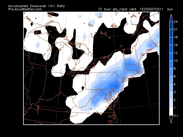
Euro went nuts on the 0z run last nite with a storm on thurs nite putting flakes in the air and then bringing another storm up the coast on sat nite, with more snow in the air. 0z GFS is weaker and flatter on the first and keeps the second well off coast, but does put flurries in. 6z GFS has more snow - pix below. 0z gfs does follow with a potent storm, accumulating snow for the 4th. See the first accum post for what the 6z gfs shows
aside note - no real frost yet this year, just a lite scattered one on the 7th


Euro


GFS


10/21
No go for the 21st, but real promising for around the 29th. Yesterday's euro had the trough lifting out with the gfs having the trough digging in (btw - euro had no rinna, gfs and every other model did). Today, euro flips to the deep trough with rinna riding just east of the coast, drawing cold air in, as does the 0z run of the gfs. Look for snow in the air, perhaps coating if the cold air can come in. Temps are in the mid 30's though. Other issue is that this is a warm to cold air scenario which doesn't usually produce much for snow as the moisture leaves before the cold air arrives. But there is a 980 low off the coast, so....


Euro 10/21 for 10/29


GFS 10/21

------------------------------------------------------------------------------------


GFS


Euro


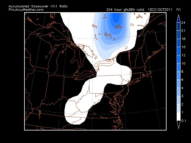
GFS and Euro agree on some snow in the region on 10/21, although not sticking and probably not making it into Danbury. Something to keep an eye on as its the first run I've seen snow on (not that I've been really looking for it yet).

Feb 25 clipper

 Got a quick 3" in 3 hours this morning Driveway was completely clear