I found this afternoons Euro run disappointing and started to look into it more to see what went wrong. The premise of this storm is that the upper low catches the surface low and the storm explodes. This has happened on past model runs, really at some time with all the different models for this storm. What concerns me about the Euro is the reformation of the low where there is heavier precip (likely thunderstorms) is. This can be 100s of miles further east as those storms shear out (which is also questionable). To demonstrate - at hr 102 the 988 low is right on the coast. Thunderstorms are out east and you can see the bend in the isobar indicating formation of a low.
Then at 114 the 988 low above becomes a 992 low and a 984 low develops out of that bend in the isobar.
Once the storms peter out, then the low is back further west.
What makes this more confounding is that at hour 102, the slp is almost under the upper low (5350 line), with another low over by that convection.
AT 108, you can see the new low jumped east, outside of the 5450 line
Then still outside 5350 but just within 5400
Then finally located where it should be.
Lows normally don't jump around like that, and once stacked, they usually stay there until they occlude. This happens all the way from the surface, to the 850 and 700mb layers. Prevents the storm from venting properly and organizing properly.
Provide a summary of the model runs for storms which may affect Fairfield County. Not a forecast, but summary of trends, positions and precip type/amount
Tuesday, January 19, 2016
Saturday, January 16, 2016
Note on teleconnections
Three major teleconnections to look at in the winter are the PNA, NAO and AO. A positive PNA typically results in ridging in the west, trough in the east, thus cold here. Negative NAO typically results in colder than normal and storminess, increased blocking as well. Negative AO typically results in cold air leaving the poles and heading south, leading to cold. Here are the teleconnections for today. Black line is the observed value.
As you can see, the AO is extremely neg, perhaps near record. PNA is fairly positive and NAO fairly negative. Yet today, we had a quick moving storm (not blocked) with rain and it reached 48 degrees at DXR, 13 degrees above normal.Heck even the EPO is barely negative, so you can't blame that either. Just one of those winters.
Jan 22-24th
1/20
Looks like I missed one heck of a day, real roller coaster for us here in CT. Out on business all day, just caught up with the printouts. So precip for DXR
GFS went from .69 yesterday at 18z up to 1.19 at 0z; 1.79 at 6z; .99 at 12z and .35 at 18z :angry:
Euro went from .21 yesterday at 12z up to .7 at 0z down to .34 at 12z.
CMC went from 1" yesterday 0z to 1.5 12z down to .75 today 0z and .35 :blink: :( for 12z
I won't ask why or how, but remain hopeful for at least our first inch of pure snow, and that someone, somewhere gets over 36". I still think 6-8 for the southern half of CT, but really not seeing much support in that anymore though NAVGEM and JMA are running NW of previous runs. NYC could still see 8-12, SNJ/PHL still in running for 12-18+. The 1" line on the snowmaps is about 60-70 miles NW of the 12" line - thats a HUGE difference
I'm ill - woke up with headache. Computer screen making me nauseous, not just the runs but staring at it. Hopefully be better tomorrow.
***********************************************************************
1/19
Afternoon - Euro operational only puts .14" of precip down for Danbury. CMC came in west. 12z GFS looks like double digit accumulation, its in the middle. Ukmet shifted east at 12z and Euro now is the eastern outlyer.
GFS ensembles are concerning as many don't have snow north of Philly. The EPS mean has remained fairly consistent out to sea, but the control is inside the benchmark still.
Most are scratching their heads now, wondering what happened to consensus. The system will be fully onshore overnight. Expect more changes as that system is sampled, not extrapolated.
Morning Cha Cha Cha Changes... but still 6"+
GFS lowered its precip amts to .74 on the 6z run. Euro lowered to .8 on the 0z run. Both had weaker storms which weren't captured as early. Both trended toward yesterday's 18z DGEX which is scary. Meanwhile, the UKMET which was furthest east is now west.
DGEX looks weird. Not a lot of precip considering the deepness of the low. Then it moves ENE.
Euro cuts down for CT but still potent.
CMC/RGEM is still impressive, but also is limited with the moisture field.
Last map is the GFS from the 6z - which is the main change for CT
Euro ensemble control still looks good.
+++++++++++++++++++++++++++++++++++++++++++++++++++++++++++++1/18 Question of the day is will Lucy pull the football this time...
Evening - DGEX shows no snow for CT except coast. NJ still gets hit hard, esp southern parts.
Afternoon quick update... Euro further west this run with 1.3qfp all snow for Danbury, but with a 40+ inch dump on VA/WVA. 12z GFS was at 1.26, but colder aloft so better snow ratios. Thats up from .9 at 6z, but still lower than the 1.4" from the 0z run.
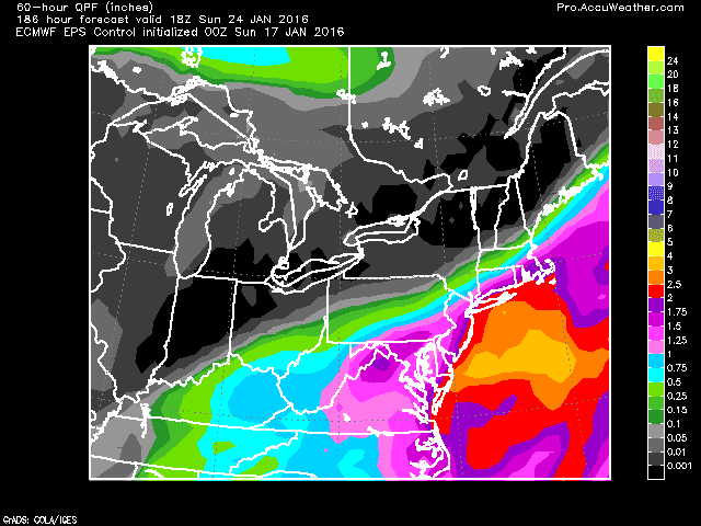
Euro QPF
Overall, models remain basically the same - 12+ inch storm all the way from VA to Boston with some areas getting 24, 36 or even more...
Morning
All models, except the CRAS, are in agreement that snow will be falling on the 23rd. Some runs are extreme. Lets start with the 0z GFS. It takes the low up and stalls it around ACY 984 or 980. 850 temps well below 0 meaning good snow growth for CT. The result is this:
6z Modifies it somewhat. But still a good snow for most.
0z Euro also bullish on snow, to the east of the gfs.
Even the DGEX is on board
And the GEM/CMC with double digit snows for a lot of folks
Even the NAVGEM which is usually further east than most of the models hugs the coast
UKMET is the furthest east, but still has the same general idea. It still hits the mid atlantic, but can't tell due to the 24hr time gaps in the panels its exact path, so it may miss SNE.
However, even with this odd consensus amongst operational models, the EPS control is slightly east if the operational and the ensemble mean is east. The GFS and CMC ens are also to the east of the benchmark. But as noted in the picture, the spread is biased west. This still affects PHL-DC though.
Will keep an eye on the model trends. Definitely worth watching for now. Could it be pushed to sea if the northern jet strengthens - sure. But with HP retreating and weak winds showing on the models, its not all that likely. The other factor is the 500mb trough could stay positive (euro leans more this way) or not close off, pushing the storm more east than northeast. Could it go further inland? Yes - typically in this time frame we see a push a bit west, also the upper low could close off early, or the trough could go negative earlier. But even then we should have enough cold air coming in from the high in Canada to give us a good snow storm (then ice/rain). So my take is that only way to miss snow is to have it go out to sea.
+++++++++++++++++++++++++++++++++++++++++++++++++++++++++++++++++++++
1/17 We may get some snow today - more interesting is that parts of NC/VA piedmont may end today with more snow for the season so far than us.
Afternoon - 12z GFS limits us to 3" now. CMC though hits us hard with 18+. UKMET getting into range and looking like the Euro, but the 500mb low cuts off a bit sooner.
Morning
For the 23rd, 0z GFS pounded us with precip with 1.6 QPF all as snow, so at least 15 inches. 6z backed off but still puts .6 down as all snow. 0z run had the lp going from AR to WV, then reforming from NC to BM at 984mb. 6z was a little further south than the BM, and weaker at 988, but same scenario. GFS ensembles support the general idea but are a bit south of the operations, with the spread to the NE.
Euro has a different route. Forms over MS, goes weakly over GA/SC, but with a lot of precip. Then craws up the coast. Its at OBX on 12z Sat at 996mb. Its a 976mb low off NJ at 6z Sunday. Precip is a mess though with much of the storm cold enough in CT, but the 850 line goes a bit wonky (see below). 1.42 total QPF with surface temps all below freezing. 925 layer and 700 layer are well below freezing. I'll guess at 8 inches of snow, and some sleet for the euro solution. The Euro ensemble control has a slightly different solution, with the low captured a bit further offshore, with a sharp cutoff of precip. Still with a 12" solution though as shown below. Euro ensemble supports this too, but is further east and a little more progressive.
Ahhhh - and then there's the crazy uncle from the north. GEM(CMC) is a little different in its approach. LP tracks to OH/PA at 998mb before reforming over NC/VA border at 995. Its barely cold enough to snow at 0z Sat, with NJ/NYC/LI rain. By 6z its a 982 low (BOMB) offshore of NJ, South of LI. Still rain for NJ, NYC, LI and southern CT. Then its captured by the upper low and drops to 972 by 12z with rain changing to snow and heavy over parts north of Monmouth. Further deepens to 964 over Cape Cod at 18z with snow pounding New England and tapering off in NYC/NJ. It seems to occlude and slowly drift east by 0z the 24th, snow winding down over eastern CT on east. Looks like 6-10 inches for CT, 3-6 Central and Southern NJ, 10-15 north of CT with Boston at 20". 50+kt winds for the Cape, with 34+kt winds in LI. This solution is NOT supported by the GEM ensembles though.
DGEX misses off shore. But hits SNJ and dumps on VA/NC Piedmont.
***************************************************************************
1/16 JMA(1-15) had a storm cutting off to our south and deepening as it headed into our area. Yesterday (and day before) Euro and GFS runs had the storm suppressed, out to sea. CMC went back and forth yesterday with rain and major snow, then this mornings 0z suppressed and 12z a hit. 12z GFS now has picked up on this as threat to the tri state. Euro remains south. JMA meanwhile has headed a bit south after yesterday's bomb. I wonder if the Euro is underdoing the SE ridge.
GFS ensembles support something nearby.
Looks like I missed one heck of a day, real roller coaster for us here in CT. Out on business all day, just caught up with the printouts. So precip for DXR
GFS went from .69 yesterday at 18z up to 1.19 at 0z; 1.79 at 6z; .99 at 12z and .35 at 18z :angry:
Euro went from .21 yesterday at 12z up to .7 at 0z down to .34 at 12z.
CMC went from 1" yesterday 0z to 1.5 12z down to .75 today 0z and .35 :blink: :( for 12z
I won't ask why or how, but remain hopeful for at least our first inch of pure snow, and that someone, somewhere gets over 36". I still think 6-8 for the southern half of CT, but really not seeing much support in that anymore though NAVGEM and JMA are running NW of previous runs. NYC could still see 8-12, SNJ/PHL still in running for 12-18+. The 1" line on the snowmaps is about 60-70 miles NW of the 12" line - thats a HUGE difference
I'm ill - woke up with headache. Computer screen making me nauseous, not just the runs but staring at it. Hopefully be better tomorrow.
***********************************************************************
1/19
Afternoon - Euro operational only puts .14" of precip down for Danbury. CMC came in west. 12z GFS looks like double digit accumulation, its in the middle. Ukmet shifted east at 12z and Euro now is the eastern outlyer.
GFS ensembles are concerning as many don't have snow north of Philly. The EPS mean has remained fairly consistent out to sea, but the control is inside the benchmark still.
Most are scratching their heads now, wondering what happened to consensus. The system will be fully onshore overnight. Expect more changes as that system is sampled, not extrapolated.
Morning Cha Cha Cha Changes... but still 6"+
GFS lowered its precip amts to .74 on the 6z run. Euro lowered to .8 on the 0z run. Both had weaker storms which weren't captured as early. Both trended toward yesterday's 18z DGEX which is scary. Meanwhile, the UKMET which was furthest east is now west.
DGEX looks weird. Not a lot of precip considering the deepness of the low. Then it moves ENE.
Euro cuts down for CT but still potent.
CMC/RGEM is still impressive, but also is limited with the moisture field.
Last map is the GFS from the 6z - which is the main change for CT
Euro ensemble control still looks good.
+++++++++++++++++++++++++++++++++++++++++++++++++++++++++++++1/18 Question of the day is will Lucy pull the football this time...
Evening - DGEX shows no snow for CT except coast. NJ still gets hit hard, esp southern parts.
Afternoon quick update... Euro further west this run with 1.3qfp all snow for Danbury, but with a 40+ inch dump on VA/WVA. 12z GFS was at 1.26, but colder aloft so better snow ratios. Thats up from .9 at 6z, but still lower than the 1.4" from the 0z run.
Euro QPF
Overall, models remain basically the same - 12+ inch storm all the way from VA to Boston with some areas getting 24, 36 or even more...
Morning
All models, except the CRAS, are in agreement that snow will be falling on the 23rd. Some runs are extreme. Lets start with the 0z GFS. It takes the low up and stalls it around ACY 984 or 980. 850 temps well below 0 meaning good snow growth for CT. The result is this:
![]() |
| Yes that is 36-42 inches in one storm in SEPA |
6z Modifies it somewhat. But still a good snow for most.
0z Euro also bullish on snow, to the east of the gfs.
![]() |
| Euro widespread 12+ with 24+ local |
![]() |
| DGEX 18+ |
Even the NAVGEM which is usually further east than most of the models hugs the coast
UKMET is the furthest east, but still has the same general idea. It still hits the mid atlantic, but can't tell due to the 24hr time gaps in the panels its exact path, so it may miss SNE.
However, even with this odd consensus amongst operational models, the EPS control is slightly east if the operational and the ensemble mean is east. The GFS and CMC ens are also to the east of the benchmark. But as noted in the picture, the spread is biased west. This still affects PHL-DC though.
Will keep an eye on the model trends. Definitely worth watching for now. Could it be pushed to sea if the northern jet strengthens - sure. But with HP retreating and weak winds showing on the models, its not all that likely. The other factor is the 500mb trough could stay positive (euro leans more this way) or not close off, pushing the storm more east than northeast. Could it go further inland? Yes - typically in this time frame we see a push a bit west, also the upper low could close off early, or the trough could go negative earlier. But even then we should have enough cold air coming in from the high in Canada to give us a good snow storm (then ice/rain). So my take is that only way to miss snow is to have it go out to sea.
+++++++++++++++++++++++++++++++++++++++++++++++++++++++++++++++++++++
1/17 We may get some snow today - more interesting is that parts of NC/VA piedmont may end today with more snow for the season so far than us.
Afternoon - 12z GFS limits us to 3" now. CMC though hits us hard with 18+. UKMET getting into range and looking like the Euro, but the 500mb low cuts off a bit sooner.
![]() |
| 12 Crazy uncle hits NEPA and Westchester/Fairfield |
Morning
For the 23rd, 0z GFS pounded us with precip with 1.6 QPF all as snow, so at least 15 inches. 6z backed off but still puts .6 down as all snow. 0z run had the lp going from AR to WV, then reforming from NC to BM at 984mb. 6z was a little further south than the BM, and weaker at 988, but same scenario. GFS ensembles support the general idea but are a bit south of the operations, with the spread to the NE.
Euro has a different route. Forms over MS, goes weakly over GA/SC, but with a lot of precip. Then craws up the coast. Its at OBX on 12z Sat at 996mb. Its a 976mb low off NJ at 6z Sunday. Precip is a mess though with much of the storm cold enough in CT, but the 850 line goes a bit wonky (see below). 1.42 total QPF with surface temps all below freezing. 925 layer and 700 layer are well below freezing. I'll guess at 8 inches of snow, and some sleet for the euro solution. The Euro ensemble control has a slightly different solution, with the low captured a bit further offshore, with a sharp cutoff of precip. Still with a 12" solution though as shown below. Euro ensemble supports this too, but is further east and a little more progressive.
![]() |
| swiss cheese 850 temps |
![]() |
| sharp precip cutoff in Southern NE |
![]() |
| Snow map - this will change over the days |
DGEX misses off shore. But hits SNJ and dumps on VA/NC Piedmont.
***************************************************************************
1/16 JMA(1-15) had a storm cutting off to our south and deepening as it headed into our area. Yesterday (and day before) Euro and GFS runs had the storm suppressed, out to sea. CMC went back and forth yesterday with rain and major snow, then this mornings 0z suppressed and 12z a hit. 12z GFS now has picked up on this as threat to the tri state. Euro remains south. JMA meanwhile has headed a bit south after yesterday's bomb. I wonder if the Euro is underdoing the SE ridge.
![]() |
| 1-15 jma |
![]() |
| 1-16 JMA |
![]() |
| GFS ens 12z |
Friday, January 8, 2016
Jan 16-18
1-16 - result - rain. Some mix in MA and UNY.
1-15 Afternoon - GFS is warmest and with the most precip. Euro and NAM runs are within a degree of being a frozen event. So right now, its 80% likely all rain, 10% mixed, 10% accumulating snow.
Morning Euro now has Western CT borderline for snow, and Hudson Valley, Catskills and Poconos prime for snow. GFS not as cool. The 980 low below goes from Delmarva to benchmark, a classic major noreaster path. The problem is the lack of cold air. As the storm deepens, it generates its own cold air, which the Euro is reflecting as it is a 980 low vs a 988 low for the gfs 6z. The 0 at 850mb line is about 50-70 miles NW of the euro on the gfs. CMC is also weaker and further south, showing only rain. NAM is inbetween GFS and Euro - temporarily deepening and cooling off the boundary layer, but moving the storm a little east and not as strong, with the 850 line just to the NW of BDL/DXR/POU. But still gives the Berkshires and Hudson valley north of the CT line snow. Not much precip in NEPA though and the 850 line stays north of NJ.
1-14 quick afternoon update - Euro, RGEM and GFS bring storm back to BM on the 12z runs. Upper HV and Catskill, Berkshires, Poconos could have some snow. GFS much weaker than before - interesting twist. GFS also has a nice, compact snow storm for the 23rd. 18z NAM on board now with low inside BM
Morning Models reach consensus. One storm goes to lakes, other storm passes to our east. There is a line of moisture between the two that moves over us and its rain. NAM, Euro, GFS, CMC, RGEM, UKMET, GEFS and NAEFS all look to be passing SE of the BM. EPS still has it inside, but rain.
Will monitor and post only if there are further changes. note - did have another dusting this morning and there could be some mix Sat morning, but more likely just rain.
Nothing all that promising on the EPS or GEFS for the next 15 days. Storms slide out to sea until days 10-15 when it warms up and cutters to the lakes show up.
%%%%%%%%%%%%%%%%%%%%%%%%%%%%%%%%%%%%%%%%
1-13 12z update - 12z gfs goes to only .29 precip with 850 temps hovering around 0. Euro keeps 850 temps under 0c, has .22" of precip. Lower level temps are still a little warm though so it may melt on the way down, or fall as wet snow. The Euro actually looks like the earlier NAM run where an arm of moisture reaches out to the GL low. CMC still bullish with a 976 low hitting nyc and eastern PA getting some good snow.
Morning impression - models still in disarray. All are sensing a stronger southern storm, but the Euro operational shifted to an almost out to sea solution. The last three runs of the GFS are showing a 972 low passing outside, over and inside the benchmark. CMC has a 964 low passing inside the bm hitting Maine, with just about all of New England as rain. 850 temps still remain just a bit too warm. RGEM shows a 968 low over Cape Cod canal which lowers to 960 by the time it hits Maine. Maine does score some heavy snow inland from this. The GFS runs try to cool off that level, but its not impressive enough compared to the strength of the offshore low. Euro is cool enough now at 850 but the bulk of the precip misses right. UKMET shows the low moving from Columbia SC at hr 72 to Nova Scotia at hr 96. 850s also quite above 0c at hr 72. FWIW - NAM looks like the Euro, with an arm of moisture between the GL low and the coastal moving through at hr 78 - 850s support frozen, 925mb layer too warm.
********************************************************************
1-12 So, turns out you can't just copy and paste the images. It pastes the link instead, and that gets updated, so disregard the pics from 1-11. The trend from 1-11 has continued with the GFS going from a 992 low over Cape May at 7am sat to 988 east of Delmarva at 6z to 984mb low east of ACY. However, the northern stream storm is doing some dirty work to bring the warm air, surface and 850 levels, up the coast prior to the southern storm. Below are the 850 heights and temps from Euro and GFS. If the 850 low can transfer earlier and a bit more to the south, that 0c line may make it down across CT and the hudson valley. So still mostly rain with a chance to turn to snow at the end so far for CT. But that line isn't so far away anymore and while it may shift northwest again, the southern storm may continue to strengthen over the runs and draw that line further south. Trending well - see what happens tomorrow. Another storm exits off OBX on the 17th/18th.
1-11 Unbelievably, the story of this winter, the storm is now going to the lakes. However, there is some signs of a stronger secondary/double barrel forming, as seen on the Euro. But the air in front is just too warm. This despite the cold blast with snow showers coming on the 12th/13th.
CMC trended colder from 0z to 12z, as did the Euro
So its not time to stop coverage on this one.
1-8 Next time frame for a storm is the 17th to 19th. Cold air will be in place for this one, and timing should be right. Now whether it goes to our west (snow to rain), east (snow) or out to sea needs to be worked out. 0z gfs seemed tame on this, as did 0z eps which just misses. The 6z GFS puts out over 2" of precip, mostly snow.
1-15 Afternoon - GFS is warmest and with the most precip. Euro and NAM runs are within a degree of being a frozen event. So right now, its 80% likely all rain, 10% mixed, 10% accumulating snow.
Morning Euro now has Western CT borderline for snow, and Hudson Valley, Catskills and Poconos prime for snow. GFS not as cool. The 980 low below goes from Delmarva to benchmark, a classic major noreaster path. The problem is the lack of cold air. As the storm deepens, it generates its own cold air, which the Euro is reflecting as it is a 980 low vs a 988 low for the gfs 6z. The 0 at 850mb line is about 50-70 miles NW of the euro on the gfs. CMC is also weaker and further south, showing only rain. NAM is inbetween GFS and Euro - temporarily deepening and cooling off the boundary layer, but moving the storm a little east and not as strong, with the 850 line just to the NW of BDL/DXR/POU. But still gives the Berkshires and Hudson valley north of the CT line snow. Not much precip in NEPA though and the 850 line stays north of NJ.
1-14 quick afternoon update - Euro, RGEM and GFS bring storm back to BM on the 12z runs. Upper HV and Catskill, Berkshires, Poconos could have some snow. GFS much weaker than before - interesting twist. GFS also has a nice, compact snow storm for the 23rd. 18z NAM on board now with low inside BM
![]() |
| Euro 12z |
![]() |
| gfs 12z |
Morning Models reach consensus. One storm goes to lakes, other storm passes to our east. There is a line of moisture between the two that moves over us and its rain. NAM, Euro, GFS, CMC, RGEM, UKMET, GEFS and NAEFS all look to be passing SE of the BM. EPS still has it inside, but rain.
Will monitor and post only if there are further changes. note - did have another dusting this morning and there could be some mix Sat morning, but more likely just rain.
Nothing all that promising on the EPS or GEFS for the next 15 days. Storms slide out to sea until days 10-15 when it warms up and cutters to the lakes show up.
%%%%%%%%%%%%%%%%%%%%%%%%%%%%%%%%%%%%%%%%
1-13 12z update - 12z gfs goes to only .29 precip with 850 temps hovering around 0. Euro keeps 850 temps under 0c, has .22" of precip. Lower level temps are still a little warm though so it may melt on the way down, or fall as wet snow. The Euro actually looks like the earlier NAM run where an arm of moisture reaches out to the GL low. CMC still bullish with a 976 low hitting nyc and eastern PA getting some good snow.
![]() |
| 12z CMC |
Morning impression - models still in disarray. All are sensing a stronger southern storm, but the Euro operational shifted to an almost out to sea solution. The last three runs of the GFS are showing a 972 low passing outside, over and inside the benchmark. CMC has a 964 low passing inside the bm hitting Maine, with just about all of New England as rain. 850 temps still remain just a bit too warm. RGEM shows a 968 low over Cape Cod canal which lowers to 960 by the time it hits Maine. Maine does score some heavy snow inland from this. The GFS runs try to cool off that level, but its not impressive enough compared to the strength of the offshore low. Euro is cool enough now at 850 but the bulk of the precip misses right. UKMET shows the low moving from Columbia SC at hr 72 to Nova Scotia at hr 96. 850s also quite above 0c at hr 72. FWIW - NAM looks like the Euro, with an arm of moisture between the GL low and the coastal moving through at hr 78 - 850s support frozen, 925mb layer too warm.
********************************************************************
1-12 So, turns out you can't just copy and paste the images. It pastes the link instead, and that gets updated, so disregard the pics from 1-11. The trend from 1-11 has continued with the GFS going from a 992 low over Cape May at 7am sat to 988 east of Delmarva at 6z to 984mb low east of ACY. However, the northern stream storm is doing some dirty work to bring the warm air, surface and 850 levels, up the coast prior to the southern storm. Below are the 850 heights and temps from Euro and GFS. If the 850 low can transfer earlier and a bit more to the south, that 0c line may make it down across CT and the hudson valley. So still mostly rain with a chance to turn to snow at the end so far for CT. But that line isn't so far away anymore and while it may shift northwest again, the southern storm may continue to strengthen over the runs and draw that line further south. Trending well - see what happens tomorrow. Another storm exits off OBX on the 17th/18th.
![]() |
| Euro mslp, precip and 850 line |
![]() |
| Euro once 850 lows separate |
![]() |
| GFS just after 850 lows separate |
![]() | |
| 12z gfs mslp |
1-11 Unbelievably, the story of this winter, the storm is now going to the lakes. However, there is some signs of a stronger secondary/double barrel forming, as seen on the Euro. But the air in front is just too warm. This despite the cold blast with snow showers coming on the 12th/13th.
| Euro with stronger secondary |
![]() |
| 12z CMC |
So its not time to stop coverage on this one.
1-8 Next time frame for a storm is the 17th to 19th. Cold air will be in place for this one, and timing should be right. Now whether it goes to our west (snow to rain), east (snow) or out to sea needs to be worked out. 0z gfs seemed tame on this, as did 0z eps which just misses. The 6z GFS puts out over 2" of precip, mostly snow.
GFS 0.5 Degree FORECAST FOR: LAT = 41.38 LON = -73.46
06Z JAN08 * - APPROXIMATED
2 M 850 SFC SFC 700 6 HR 500 1000
TMP TMP PRS RHU RHU QPF HGT 500
(C) (C) (MB) (PCT) (PCT) (IN) (DM) THK
MON 06Z 18-JAN 1.0 -3.1 1011 95 99 0.07 547 538
MON 18Z 18-JAN 1.5 -2.4 1008 93 98 0.18 545 538
TUE 06Z 19-JAN 1.2 -4.8 999 96 99 0.78 539 540
TUE 18Z 19-JAN 1.0 -5.1 994 95 97 0.63 533 538
WED 06Z 20-JAN -0.9 -1.3 1004 95 94 0.17 539 536
| crazy 6z gfs run |
| more likely 0z gfs run |
| Euro operational looks out to sea |
| EPS also out to sea, but closer than op |
CMC is inland
-
11/27 update - happy thanksgiving. GFS has gone from major noreaster, to huge cutter to lakes and now has a minor clipper system sinking do...
-
2/9 Set up is an upper low over TX that heads northeast into TN valley and then transfers off the coast. At the upper levels, there's ...
-
2/22 - results 5.25 inches. Snow started at 2, lasted 12 hrs with varying intensity and types of snow. Kudos for the models, weather serv...