Friday, January 27, 2012

Cold air pictures

2-1 Same timeframe, now warmer. No cold after this, yet.


1-27


1-27 Models have been on and off in showing cold in the long range. Here are some pics from todays runs with the most extreme days for the next two weeks.

Feb 3-5

1-30
0z runs
Euro surpresses fridays wave and sundays wave. No sustained cold.
GFS surpresses fridays wave and hits us with storm Sun nite. Snow/rain system as it comes too close. 6z brushes us on friday with light snow, nothing on sat, sun or mon. Both GFS runs keep it cold after Thursdays front. cold recedes at end of run
CMC still develops it thurs/fri as a rain/snow, slides sunday storm out to sea. Cold stays until end of run
DGEX blasts storm to our west, brings rain

1-29
Euro pushes it to the lakes - rain. CMC has a direct hit - snow. 0z GFS has a nice light snow storm. 6z pushes it out to sea south of us as a wave, with another low going out e of SC. JMA has a wave sliding right over us with temps just cold enough for snow. Nogaps has a wave sliding south with a major storm passing to our east on Sun. UKMET has a 1024 High just to our south on fri with a 1008 low in TX - would assume that goes to lakes and its really warm. DGEX has us getting creamed with a 994 Low on Sat morn.

12 z runs
GFS - slides Friday weak storm ots. Sun storm ots
CMC - consolidats on Sat - brings weak storm way close to us, snow/rain/snow event
Euro - slides 1008 south of CT, but too close for all snow. Snow/rain/snow event.
UMKET -hard to see anything
DGEX - slides both out to see like GFS


1-28 - All models have lost the bulk of the storm and instead push a wave out to sea, in some cases all the way down to SC

1-27 Finally some truly interesting scenarios coming up.

Superbowl weekend is what I hope to be the start of a more sustained winter pattern. While temps this week are still above normal, we do have a chance at snow showers on Sunday, then some up and down temps.

A northern stream system is going to pass to our north on Wednesday and behind it some colder air will filter in. The r/s line will be splitting CT on Thursday. Thurs nite into Friday, another northern branch storm will get far enough south to pick up some Gulf moisture. A southern system may also be there as well, heading NE. It will run into that moderately cold air from Thursday. As the storm moves E to W, along I-90, a secondary is progged to form and the energy transfer to the coast. Right now, that transfer looks to be taking place over us, so its a little too far north for all snow, but as the two systems phase, it may bomb out, drawing cold air into the system enough for a snow to rain, to snow event.

If that transfer can happen more off of NJ or MD, we would be in a good position.

Right now the Euro and Gfs are battling over which system prevails - Euro has northern system with reformation over Boston. GFS 0z has the southern system going off the coast to our south, normally a no brainer snow storm, but would be too warm this year. 6z GFS has a compromise between the two, with stronger southern storm phasing over CT. JMA has just a southern storm missing us to the south. CMC has phase take place over TN/KY and moves the storm, as it deepens, from PA to CT.

So GFS and JMA are southern, Euro is Northern, CMC is early phase and right over us. Based on this winter, I'd say it moves over Lake Erie and up the St Lawrence.

12z runs - GFS had a weak system sliding off south of us, with some snow kicking back in what looks like an inverted trough. Euro has a credible storm as it abandonded the northern wave in favor of developing the southern and bringing it off nj. CMC looks to be going up Del river, with snow on the front. JMA double barrels it up, but the 850 temps are +10!

Sunday, January 22, 2012

1/28-30

1/22 - some ice tomorrow morn as temps are in the twenties.

Looking at the weekend - models split. Could be 6-10

Wednesday, January 18, 2012

1-21

1-19 All models, including the NAM which was holding out, have snow for Saturday. There is still some talk of mix, perhaps based on ground temps, but the 850 line has trended closer to Trenton. Precip output is somewhere in the .35 to .55 range, so a 3-6 inch forecast is wise.

afternoon update: storm heading further south. 850 line pushes closer to Philly, precip amounts for DXR down. Now a 2-4 inch storm. Only factor which may keep snow amounts a bit higher, is that the -8 isobar will be in the area during part of the "storm"

1-17 A little snow thurs nite, first snow storm of the "season" for Sat

Models have shown on and off a storm around the 21st. I should have paid more attention. Overall its a pretty fast mover and not all that potent.
0z Euro puts out .58 precip, all snow for Saturday, leading to about 6 inches of snow
0z has .5-.75 precip, all snow for dxr
6z gfs has .42 precip, all snow.
CMC shows borderline snow/rain with line along i-80, but moves it north later in the storm. Likely all snow for areas north of i-80
DGEX is much warmer, all rain
JMA seems to move it off south of the area with minimal effect.
12z Euro cut back precip to .45, still snow
12z gfs is down to .42, still snow.
18z gfs is now warming up at 850 and changing to rain, still some snow to start.
All NAM runs are rain with low going over us or to the north.

Friday, January 6, 2012

Pattern change

1-12 update.

Euro and GFS ensembles losing the cold in week two. GFS op is all over the place, hence the focus on the ensembles. Next ten days are still mostly cold. After that, a more zonal look, indicative of a neutral PNA and NAO. I knew the PNA would be a problem, as noted well below. I still note there is a pattern change, and while it looks warm again in the end of week two, its not a huge ridge that's causing it, just a zonal flow, with a slight dip/trough centered in the Midwest. Even the anomalies are not that far off. But the ensembles do trend towards climatology in the long run. And indeed, the NAO is forecast somewhat neutral, AO is negative and PNA is neg to neutral.

-----------------------------------------------------------------

1-10 update. Euro and GFS ensembles still showing a change to normal to below normal 850 temps. Operational Euro still mainly cold, but with quick warmups. Operational GFS is signficantly warmer than the ensembles and looks very much like the same pattern after a few cold outbreaks.

------------------------------------------------

1-6

With stratospheric warming over the poles, the polar vortex should be disturbed and the AO should go negative. This along with the southern oscilation index going neutral ( ie La Nina going neutral) rapidly, should shake the pattern up a little.

We've seen the warming event modeled for a few weeks now, and the observations are matching the prediction. So I've been watching the long range models for signs of a change.

The first thing I noticed a while ago, in another post somewhere, is that the storms and highs are now sliding out of Canada. While the troughs are still lifting out over us, resulting in a cold then warm pattern. This is actually the pattern I thought most of the winter would have. The models, for weeks now, have shown a return to normal to colder than normal temps and a broad trough in the last 5 days of the run. But those temps always moderated or were replaced as the event neared. So once past 192 hrs, instead of 5 days of cold, it becomes 2 days of cold, 3 warm.
Example - todays Euro ensemble control (mean) has the following temps for CT at 850mb. Normal is around -3 or so.
Today - -10
Sat +7
Sun 0
Mon-wed - 5 to 0
Wed to Fri +5 to +10
Fri to Tues - 10 to 0
Tues and wed +5
Wed-Sat dropping to -25 (real cold)
But you can see the longest stretch of cold is at the end.

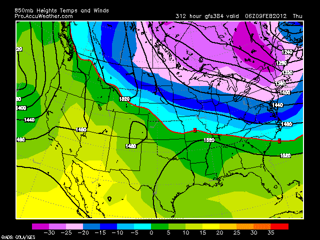
The GFS operationals have now been consistently showing colder air (albeit normal)
18z yesterday is below 0 at 850 from 192 hrs to 384, with only a 6hr period above.
oz has below 850 from 168hrs to 384 with one day above
6z also starts at 168 hrs and is below 0 all the way to 384, with som -20 to -25 showing up
12z run goes from 156hr all the way through, though less extreme
18 z went to more of a zonal flow after a brief cold break.

Only problem is that this look is more typical for a positive PNA/neg AO, and a strong negative PNA is being forecast by the ERSL, with CPC showing more of a neutral, wavy look.


Wednesday, January 4, 2012

Out of sheer boredom...12th - 13th maybe not!

1-13 Woke up to radio saying black ice. Temp of 36 at 6am. 48 at 8am, then snow and back to 36 by 10am. Temps dropped into the 20's by late afternoon and winds gusted 20-30mph. A flake once in a while, but most of the snow dried up before it got here.

1-12 36 and rain. Snow in N CT though, enough to delay schools and plow.

1-10 NWS had 1-3 inches in their forecast earlier today, then scaled it back to an inch. GFS runs today all put snow on the ground in CT, but not south of CT. 18z Nam puts some snow in far NW Jersey and PA as well. 0z run is way warmer aloft with not even flakes falling in NJ nor accumulating in S CT. N CT still gets an inch. Catskills and VT should make out ok with this storm, finally.

1-9 Snow on front and end of this one?? And out of nowhere, a high over Quebec, funneling in cold air, creating cold air damming (CAD). Will surface temps support accumulating snow - 850 temps do!

12z euro and gfs 72 hr time frame for thursday morn has the 850 line over NYC, with the CMC closer to i84 (which is colder than the 0z run) and UKMET at the CT/MA border. NAM is not signed onto it as of 12z. GFS ens and Euro Ens are too. Right now, based on GFS and Euro QPF output and 850 temps, about 2" can fall before turning to rain. Will watch if a colder trend continues. Also, the GFS puts out an inch or two on the back end. This is possible since the upper low is hanging around, but typically it dries out to only flurries.

---------------------------------------------------------------------------------
1-6 - Only agreement is that it will rain. Oddly, most of these tracks would normally be a strong snow storm.
0z Euro - keeps upper disturbances (uds) separate. Brings LP up apps to BM
12z - keeps separate, brings LP up apps, but then phases uds and lps over NNE
0z CMC - same as 0z Euro
12z - way different, very creative. Brings LP and UDS from south west of apps, passes front, spawns secondary, which misses us out to sea.
DGEX - looks like Euro, but a colder system aloft, stacked, with 540 line island in middle, so chance for wet snow where that happens.
UKmet - 0z looks like Euro, 12z run brings it further northwest.
GFS - 0z - track like Euro, but colder and west of BM, with 850 line in E Pa.
6z - up apps, over BM. SLP meets the northern LP (NLP) in Maine, with 850 line in central PA
12z UDs are separate, but barely. LP's phase over PA, stacked under the Southern UD. Secondary forms as trough is negative, and brushes the coast the next day with snow.


1-5 Still multiple solutions, all rain at this point. Still worth watching.

0z gfs - keeps northern and southern separate, moves both east, southern ends up coming up the coast, right over us.
6z - almost phases the two, but drops the northern into west great lakes, while southern goes up apps, the two lows phase over the lakes, but the upper system from the southern stream heads to nova scotia
12z northern system cuts off in the upper plains, southern system goes up oh/tn valley, out off of nj. looks stacked (upper over lower) which also makes it a colder system with the 540 thickness coming close to snow.
0z euro - phases the upper systems over the lakes, tries to keep the surface separate with the southern system coming through oh valley to over NYC.
12z euro - keeps upper systems separate, moves one main low up the apps to over NYC.
0z cmc -keeps upper systems separate, dumps northern into plains, southern rides up apps, looking stacked, with a secondary surface low forming over new england.
12z fully phases, blizzard for western lakes, one low over the lakes.
JMA keeps the upper features separate, focuses surface pressures up the coast.

-------------------------------------------------------------

1-4 Its been looking like clearly a rain storm for the past few days, as a cut off low moves up from the south to our west. But there is also a northern system diving down. Where these two meet up, or which one gets here first, could gum up that mild looking storm. If that northern system bumps the southern to the coast, or they consolidate over our area, there may be an impressive rain/snow storm.

Tuesday, January 3, 2012

Finally saw a dusting fall.. and 1-9 or 1-10

1-5- just flurries, maybe, for the weekend. A snow squall would be exciting at this point.

1-4 Model update for weekend - trending to nothing

Euro - 0z run has clipper passing to the north, dragging warm air up for Saturday. No longer develops southern system coming up coast, but does generate a storm offshore on Sunday night out of a shortwave rounding the trough. Could also see flurries as the cold air pours in Sunday into Monday. Another sw comes over on Tues night, when it will be cold enough for snow flurries. 12z run is even more benign

GFS 0z has nothing for the weekend, slides a low off OBX Mon nite.
6z nothing for the weekend. Nothing Mon nite. Potent storm moves up on Wed, rain for everyone east of Chi-town.
12z nothing for the weekend, slides the low off OBX Mon nite. Cant rule out snow flurries Sat nite

CMC 0z. shortwave is further south than Euro or GFS, with a low forming just off the coast on Sun morn. Brushes area with snow. 12z run has nothing.

UKMET has the storm forming well offshore on Monday.


Woke up at 6, 27 degrees. Light snow started around 6:30 and coated the ground, briefly. Temps since have gone down to 23, despite bright sun.

Looking ahead...

0z runs - Euro, Canadian and Nogaps models have a small storm off the coast with some snow on 1-9. GFS, DGEX have the storm forming off SC on the 10th, and sliding ENE out to sea. Beyond that there are some signs of a pattern change, with the AO and NAO going neutral to negative. Except the PNA then flips to negative, resulting in ridging in the east. At least the high pressures are now coming out of Canada, instead of up from Texas. But the pna going negative signals the troughs dropping down into CA, cutting off over AZ/NM. Hoping the negative AO and NAO pan out in this case to keep the cutoffs in place or further south. Pattern so far has been for the upper lows to come out of AZ and ride northeast instead of opening up or staying south.


12 runs - Euro is mainly rain. GFS signed onto there being a storm now, more snow than rain for CT, parts south would be mainly rain. Canadian 12z came in with the front passing and a storm developing after it passes, and has a good snow for all the area. Nogaps looks like Canadian. These usually get lost for the next day, then push west. The other thing to watch is there is another storm forecast by all to go out to sea on Tuesday, and another coming up the coast or inland on Thursday. Thats a lot of action (too much) for this year so it looks suspicious.

Storm 3 - could be the one! (spoiler, it was)

 2/9  Set up is an upper low over TX that heads northeast into TN valley and then transfers off the coast. At the upper levels, there's ...